Back in high school, I was walking through a Pay-n-Save parking lot, looked over, and saw a cougar looking out a truck window at me. It was chained to something, just chilling and waiting in the driver's seat, and guarding the open can of Budweiser sitting in the cup holder. Got pics, but the prints are, sadly, long gone...
There was a small private zoo in town, and I think it lived there.
My visit to this monument looks like it was a lot briefer than Brent Rose's visit. No time on the water, just checking out a couple sites in the Wahluke Unit of the monument, directly across the Columbia River from the old, historic nuclear plants, and a bit above, at one point, Rose's location on the water.
On my visit, it was a gray and misty day and I arrived at sunset (for what it was... nothing but increasingly dim and gloomy light). I do have some more photos that I'll share in a later post, but I am trying to make tracks through as many monuments as possible today.
A couple quick notes... This is the first monument to be managed by the U. S. Fish and Wildlife Service (USFWS). Most of the land was already established as a National Wildlife Refuge before it was declared to be a national monument, so they retained the managment of the new monument. It is the best preserved sagbrush step biome in Washington (and most of the west, for that matter) and contains the only "free-flowing," wild segment of the Columbia River left in the United States above the first dam. For the rest of the river, it is just one reservoir backing all the way up to the next dam above...
There is very little development here. A boat launch, a couple dirt roads, the viewpoint... In fact, much of the monument is off limits to the public, including the entire Rattlesnake Unit.
The cabin at the top of the post is one of the oldest remaining structures in Franklin County, Washington. It was a part of a settlement that built up at a natural crossing on the river, and was an important hub for steam ship, peaking between 1858 and 1870. By the 1900s, most of the town was located across the river here, and was one of the towns wiped off the map completely with the establighment of the Hanford Project during World War II.
I've been wasting some time doing a little maintenance and sorting and tagging on the blog, and I just found this old post that's been sitting around as a draft since 2012.
I have no idea what I was planning on doing with it, but I went ahead and added a few photos and hit "Publish."
"I was very surprised to meet a total of 13 hikers coming up the trail. Only two groups had overnight gear. That is an awfully long day hike. Nice to see so many hikers putting in a lot of effort. The last 5 3/4 miles was very fast. I passed dozens of hikers going in and coming out."
There are myth-places. They exist, each in their own way. Some of them are overlaid on the world; others exist beneath the world as it is, like an underpainting.
There are mountains. They are the rocky places you will reach before you come to the cliffs that border the end of the world, and there are caves in those mountains, deep caves that were inhabited long before the first men walked the earth.
They are inhabited still.
Neil Gaiman, Anansi Boys
It's been too long since I've posted. I'll write more about the locations in this photo soon.
It's been awhile since I've posted a photo of the day, but I took this one while out working on www.RecreatingTheHCRH.org and really liked it, for what it is...
Goose Lake is a very interesting spot. It’s a small lake formed by a lava flow, filled with snags from later human engineering work. Originally, it’s level was a bit lower, hence the trees, but it’s level fluctuated during the year, very much like the South Prairie Lake a few miles away (though not as dramatically). At South Prairie, a lake forms in the spring from snowmelt, but then drains later in the spring through the lava flow. The best guess, though not yet confirmed, is that the prairie lake drains through lava tubes that are choked with ice until later in the season than the surface snow, and then, once the tubes melt clear, the lake quickly drains.
At Goose Lake, there was once such a drain, as well. However, this drain was located and plugged in 1930 by the Forest Service to “improve fishing” at the lake. This raised the level a bit, and killed off the trees whose tall stumps still rise mysteriously from the water here and there throughout the lake.
Such an act seems almost sacrilegious today, but back in the day, recreational use of the land was seen as a higher priority than the preservation of such a unique geological oddity, and in the long run, it could be argued that opening up the land to recreational use led to increased conservation in the region over all.
Plus, it gave us the stumps, which are pretty darn cool and gives this lake a truly unique feel.
And the fishing, apparently, is excellent. On the drive out to Goose, more often than not you’ll be following a boat to the lake.
On top of all of the interesting tidbits above, there is also this…
Published on Aug 29, 2013 Take off from Grand Coulee Airport flying over Grand Coulee Dam, Columbia River, Lake Roosevelt, Northrup Canyon, Banks Lake, Steamboat Rock. Flying a Northwing Trike WSC (weight shift control) Light Sport Aircraft with Rotax 582 65hp 2 stroke and GT5 Wing. Filmed with wing tip mounted GoPro 3 Black Edition in 1080P, edited in Premier Pro. Converted to 720P for web share.
I’ve been thinking about starting up the photo of the day again, and since I have over 3,000 new photos from our family vacation this summer, it seems like a good time to start.
I’ve been thinking about this for awhile, since I feel like I am not working on much photography these days. Sure, I’ve spent the summer running through a bunch of event photos, and I’ve been slogging through hundreds of photos for the Recreating the Historic Columbia River Highway documentary project, but these are not really what I would consider artistic, fine arts style photos, which is what I want to focus on a little more with the resumed photo of the day.
I feel like I’ve been neglecting my photography a bit and I think trying to take a few minutes to publish one decent, somewhat artistic photo every day would help keep focused on my photography a bit more than I have been for the last six months or so.
This is not to say that I haven’t been taking lots of pictures, but it is to say that most of the pictures I’ve been taking have been quick and dirty shots from events, or the survey style work on the old highway, and the focus on the art of photography is sacrificed somewhat in those environments.
Today, I am posting two pictures. I decided to start with Yellowstone and threw one up of Riverside Geyser earlier, but then I decided to start with one photo from each day of the trip.
Neither of these are among the best shots from the two week trek across the country, but I like the one below for sentimental reasons and the one above is probably the best shot from the only location I took pictures of on the 29th, which was a travel day.
The monument is built with steel from the WTC. It is partially melted and this memorial is pretty amazing. It’s the first time I’ve seen anything like this in person, and we hit it at a nice time of day, too. I’ll probably throw a picture up later on showing more detail, but I wanted to start with the wide view of the whole thing.
Like I said, not that exciting of a photo, but was an interesting and touching place to start off our trip with…
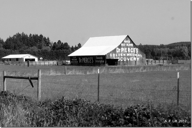
Red Blood for Weak Women. Barn. Jackson Highway. Washington. August 12, 2012. Featured: October 30, 2012.
But will it help weak writers? Probably. But probably in ways counterindicated for people such as myself.
Posted this up on Facebook a minute ago:
Novel update: A part of me just wants to dive in and start writing. Another part wants another two weeks to flesh out the details before I start. Another part is pretty sure it's all crap and will fall apart as soon as I finish the first chapter. Another part is certain that this may be the greatest piece of literature produced this decade and, because of that, it will write itself with practically no effort.
The truth is some blend of all of that.
This morning, as I get to work, I am focusing on trusting the process.
I have a plan. I know from experience that it is a good one. I need to trust myself enough to follow it.
WTF am I doing posting a picture when I have a month to write a frickin’ book!?! Keeping myself sane. I’ll be doing this from time to time. The pictures will probably be of things that remind me of the settings of the novel.
I may do this often, or this may be the only time, over the next month.
Today, sitting down to get to work, I was feeling a little scattered after running around like a chicken with my head cut off all morning dealing with the boys’ issues (one sick, the other needing a check in with a couple teachers at school) and, well, the book was just sitting there staring at me.
Posting up a picture seemed like a good way to get settled down into work mode.
And after dealing with the frustration of slow interwebs and slower computers, writing will feel simple. Just typing, not waiting on the little spinning circles and hourglasses as I hover on the edge of insanity.
(5 minutes later, still waiting on everything… Oh, yeah. This is definitely working. Typing versus this? Oh Hell YEAH!)
One final thought, inspired by an old friend. He pointed out that “most creative work fails not because of any lack of talent or ability, rather it is never finished.”
That is my biggest fear heading into this, and one of the issues that I discussed yesterday.
It's also why I decided to do NaNoWriMo this year. It’s a great motivational tool to get a solid draft done on this project. I've been avoiding work on creative writing for over a decade and it is time to get back to work, but there is also a lot of fear of failure heading into it.
That is fine, but I need to be sure that fear of failure does does not become an excuse to walk away from this.
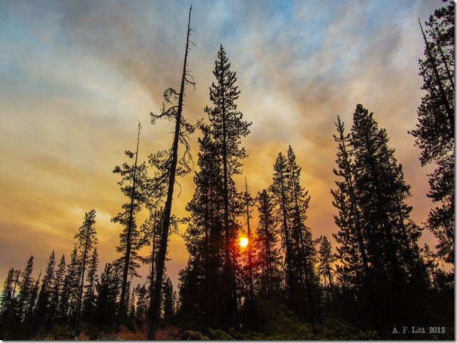
Sun rising through forest fire smoke. Diamond Lake. Umpqua National Forest. Oregon. August 12, 2012. Photo of the Day by A. F. Litt: October 14, 2012. Start of a long term hiatus for the POTD.
Hiatus
Today I am posting the 412th photo of of the day.
Is this my last photo of the day post? It very well might be. I am using the word hiatus instead of end, but it will probably be a long hiatus.
Originally, last December and January, I was really aiming to get 366 photos up this year, one every day. Life was a little more hectic than I expected, and daily posting this year has actually been the exception, not the norm.
Still, I tried to get back in the habit through the month of September. But then October happened and, half way through the month, this is my second post.
It seems like it is time to put a capstone on this project and to move on, for now.
When I first started the POTD on February 13, 2011, I was in a very different place in life than I am right now. I was in a rebuilding phase and, as a part of that rebuilding, I wanted to put more focus on photography as I moved ahead in life.
As I wrote when I created the first POTD album on Facebook:
I've decided to post one "featured" picture every day that I have internet access. Just for the heck of it. Feedback is appreciated. Some, obviously, will be better photographs than others. What I post will be somewhat reflective of my mood, so I may choose some shots more for their personal meaning to me than for their artistic "worth." It is just something to do, it sounds like fun, and it will kick my butt into gear getting out there to take some more pictures!
Well, if the main goal of the project was to inspire me to take more photos, that is a mission accomplished.
In fact, one of the main reason that I am taking a break from this project is that I now have thousands of photos sitting on my hard drives that I haven’t ever looked at on my computer, let alone edited or posted anywhere.
These days, in fact this is precisely why there have been so few POTD posts this month, I would rather spend the 45 minutes to an hour a day it takes to select a photo, edit it, post it, and share it working on editing this back log of pictures than spending all of that time working on one photo.
For the first six months or so of the POTD, I was worried that I’d run out of photos. That I’d have a hard time finding 360 plus photos worth posting. Now, it is just the opposite problem. There are so many pictures sitting on my hard drive untouched and forgotten… Not all, hell most, are what I’d consider POTD quality, but the good ones are getting lost in the shuffle and I need to start spending more time getting them cleaned up and brought out of the dark and into the world.
Also, life is getting busy again. We are entering into a busy phase with one of my kids’ special needs, I want to put at least one calendar up for sale by the end of October, most of my free time in November will be spent writing a novel for National Novel Writing Month (NaNoWriMo), and in December, along with the holidays and long school breaks for the kids, I want to spend quite a bit of time compiling and curating my photos to enter some contests with end of the year deadlines and to start pursuing some new goals with my photography.
Coupled with all of this, I have some new projects I am working on with my blogs. One, for an example, is over on Suburban Eschatology Part Two where I am starting work on a series of posts about raising a child with Asperger’s Syndrome. Meanwhile, here on Rubble, I am trying to work through a series of posts I’ve been wanting to complete for over a year now on some local hikes, parks, and geological features.
So, I am busy. And, hopefully, there will be a lot more going on here on Rubble than just one photo a day, at best, or a couple a month, at worst.
I can safely say that this will be the last Photo of the Day until December, at the earliest. In 2013, I might return to the practice. Then again, maybe not. Only time will tell. Instead of a Photo of the Day, what I may do instead is throw up a semi-regular Featured Photo post, which is really what the POTD has become anyway.
However, that is the future and this is today. I can see possibilities where the POTD becomes a gratifying creative outlet for me once again. However, until that happens, until it is something I am fired up about again and not something where I randomly open up a recent folder and grab pretty much the first picture that catches my eye, I think it is time to put this project to bed.
Whether it ever wakes up again, we’ll see. I did, intentionally, choose a sunrise photo for today’s post, not a sunset.
Photo of the Day by A. F. Litt: October 1, 2012, Middle Fork Valley at Sunset
For a time this year, I tried to keep the POTD alive by not posting them on the blog, but just on 500px & deviantArt. Looking through the “recent” POTD posts, I noticed that I did this for the October 1 picture as well.
Quartz Mountain. Snoqualmie Lake Trail. Washington. August 14, 2012. Photo of the Day by A. F. Litt: October 1, 2012.
I spent a lot of time when I was younger in this area outside of North Bend, Washington. The last couple years, I got to revisit the area and it has changed a lot. New campground and day use facilities, etc… Some of the old roads are closed, which I don’t like, but if it helps to preserve the area, I suppose that is for the best.
When my dad and I first went out there in our big, old orange pick up truck, I was amazed that a place like this existed only minutes from our home in Issaquah. I remember saying, “I can’t believe this isn’t a National Park. It’s almost like Yosemite out there.”
Well, I had never been to Yosemite at that point, I have since, and while the Middle Fork is pretty spectacular, it might not quite be Yosemite spectacular, though for being, like I said, a few minutes from home, it was pretty damn good.
I suppose I am not the only one who felt that way. This year, I found these quotes about the area…
This is from a development plan for the area from the mid-1990s and describes the area as I knew it as a teenager…
The Middle Fork Valley is one of the more significant, close-to-home places in King County. Often called the “Yosemite of the Cascades,” the Valley is less than one hour drive from over one million people within the Seattle metropolitan area. As a destination, the Valley presents a beautiful, yet mysterious, challenge. There is no managed entry into the Valley, no centrally located orientation point that offers watershed-wide interpretive or wayfinding information, and no wayside exhibits, markers or developed interpretive facilities. (9)
Before our trip out there this summer, looking for trails, I saw another quote that I couldn’t find today mentioning that, if this area was located this close to pretty much any other city than Seattle, it probably would have been a major National Park. However, since Seattle is so spoiled with natural wonderlands in such close proximity, that this area has pretty much been overlooked by everyone.
When my dad and I first stumbled into this valley back in the 1980s, this is what surprised me the most. How nobody seemed to know about it. Well, not the right people, at least. We found it on our Mt. Baker-Snoqualmie National Forest map, a long, long road leading way back into the mountains, and decided to go check it out.
The development report describes the drive as it was back then. The road is a little better maintained these days, but this still pretty much describes the drive today.
It takes approximately 30 minutes to drive the Middle Fork River Road from the mouth of the Valley to Taylor River. The road is narrow, rough and windy in places, requiring attentive, slow driving. But the focus is well rewarded. As one enters the Valley, time slows and a quiet forest of trees encloses the roadway. Ferns, logs and moss thicken the wet forest floor. And the rushing of the River can be heard clearly through the trees.
As one moves upstream, the forest canopy opens and closes. One catches only glimpses of lonely peaks, ridges, and the River. Finally, at the Middle Fork bridge, views up and down the River’s meanders reveal the full, u-shaped figure of the Valley from Bessemer Mountain to Russian Butte.
Beyond the Middle Fork bridge, the rough road leads deeper up the Valley. It widens and straightens but closes under trees as it moves nearer the River. Now, the Middle Fork is ever present, separated from the road at times only by wetlands and small streams tumbling off of the Valley’s west ridges. Muddy vehicle tracks and narrow spurs leading to the river’s edge are numerous. As the road finally reaches Taylor River, the landscape opens on to young forest and giant old trees, the joining of the Taylor and Middle Fork, and the looming cliffs of Garfield Mountain. (25)
Through the late 1980s and early 1990s, it was pretty “Wild West” out there. Contrary to my first impressions, a lot of people, apparently, knew about the area… The road back there was always busy, but it could be a fairly rough crowd. In fact, later in High School, almost every one I knew learned about the Middle Fork, since this is where most of the major keggers occured, out at Taylor River, as everyone called it.
Again, from the 1990s development report:
Some hiking and boot-built trails, (many familiar to only the most intrepid of hikers), used and unused logging and spur roads, and a single main road carry recreationists to high elevation trails and to backcountry and wilderness destinations. Meanwhile, many visitors experience the river corridor in glimpses from the road. They stop for short visits at locations where the river is visually or physically accessible and shorelands appear safe and unlittered, or at pullouts where parking looks relatively hazard-free. Many of the sites provide excellent river views and relatively easy river access, but some are poorly located and visitor use has resulted in significant stream-side erosion and vegetation damage. All are usually littered with garbage or human waste. Given these conditions, visitors do not generally experience a positive or comprehensive sense of the river or the larger Valley. (9)
Things got even worse, it seems, before they started getting better.
The Middle Fork Snoqualmie River valley has come a long way. Once the playground of loggers and miners, the valley was stripped of many of its resources and then left torn and tattered. Soon came the unsavory characters, making the Middle Fork their own personal dumping ground. Drug users and meth producers fouled the forest with their toxic concoctions. Then came the Middle Fork Coalition, a hard-working group of volunteers who helped the Forest Service clean up the valley while developing plans for its future greatness. Roads were closed, trails were built, garbage dumps were cleaned up. Peace and quiet was restored. Today, the Middle Fork Snoqualmie is a recreationist's dream, and the Middle Fork Trail is one of the best recreational resources in the valley.
Diving out there last year, I was amazed at the changes. Day use areas and a campground. Though, as I said, I was a little frustrated with the Dingford Creek gate. Once, dad and I made it all the way out to the end of the road below Dutch Miller Gap, and I remember that it was pretty spectacular out there. However, I also remember that the road was in pretty rough shape back then.
I don’t ever remember the Taylor River road being open beyond the bridge, but from what I was reading today, it apparently was open off and on for a while through the 1990s, at least. Of course, it is permanently gated now and the road is, rather dramatically, returning to nature.
We spent a couple nights in the forest service campground this summer. Not the first night I’d spent out there, but the first in a real campground. The first night we were there this August, as we were settling in for bed, I got up and locked the van.
The Ex One asked me if that was really necessary since there was only one other group in the entire campground that night (it was a weeknight, the weekend was booked full to capacity). I mumbled something about her not remembering that area like I did, and I locked up.
Apparently, more development is in the works. First up, paving the road out there. I have bitter sweet feeling about this. Yes, it would be nice to get in and out of the area a little quicker and with less washboards and pot holes bouncing us everywhere, but a paved road just means more people.
I suppose the valley isn’t much of a secret place anymore, and more people are inevitable. But I think that is what was fun about the area when I was young. It was a secret place. Of course, there were good things and bad things about that, but it was fun.
Now the Forest Service and King County have agreed to pave the stretch of the Middle Fork Snoqualmie Road (FR 56) from where the current pavement ends (MP 2.7) to the Middle Fork Campground (MP 12.4). A Memorandum of Agreement (MOA) between the Federal Highway Administration, King County Department of Transportation and the US Forest Service has been completed for $20 million the proposed project.
Camp Brown
Crashing around on the old roads out up the Middle Fork in our old orange pick-up, or later on with my little Blazer, we had a lot of fun driving up random spurs and looking for hidden places. Never found much except for the occasional washout and the joy of having to back a quarter mile down a steep and windy road to a place where we could turn around…
Well, today the roads are gated. But we do have the internet, so instead of spending long afternoons poking around for secret places and crumbling history, we can actually just look them up and head out directly to them.
There is a lot of history out there. This was obvious back in the day, but before the internet it was hard to find out much about it. All the woods east of Seattle have a nearly haunted feeling from their heavy use over the years. Logging, mining, etc...
The area I grew up in felt like this. You could sense the ghosts of times long past wandering through the second and third growth forests.
Those woods are now long gone, mowed down one final time and replaced by endless housing developments. But the Middle Fork woods remain, and they too are filled with artifacts and ghostly reminders of a nearly forgotten past.
Working on these pictures earlier, I became curious about the Camp Brown mentioned on this old road sign, miles up a trail now near what used to be the terminus of the Taylor River Road…
Apparently, this might be a pretty old sign… Here are some mentions of Camp Brown:
In 1937 the NBTC abandoned Camp Brown and started to pull the main rail line. The CCC road was built in 1938 and extended to Goldmeyer Hotsprings in 1939. In 1941 the NBTC indicated the intention to stop railroad logging and the rail lines were pulled out in 1942 (it seems highly unlikely according to the most reliable sources that the rails were sold to pre-war Japan as some rumors have indicated). In 1942 the rail line was converted to a truck road.
Yesterday, Schrenk and Johnson pointed out one area along the Middle Fork road where a former logging camp called Camp Brown has been transformed into a deep-rutted, mud-holed obstacle course -- with trees as the obstacles. The practice of driving rigs around in the mud -- or in some cases, the river itself -- is called "mudding.”
Backpacker Joe:There are a few small remains. In the old days when I/we/you had to ford the creek there I remember a could old wooden artifacts. Now that you can walk across the bridge you might head up there a take a look.
...
"1928-29 Railroad extended to 1 mile past Taylor River. Camp Brown is built (named after Robert Brown, civil engineer for laying track on the Middle Fork railroad who was run over and killed by a backing locomotive in 1928)."
mtnresqr: From what I remember as a kid, Camp Brown was a USFS Guard Station alongside Middle Fork road. Like around late 1950's. A small Ranger Station in a wooden cabin. Then the log cabin got rickety or damaged and was torn down. The USFS put a concrete pad down, to park a small camping trailer, for a seasonal USFS place. Maybe around early 1960's.
And, back before that, over on Rainy Creek, on other side of MF river, there was a water works, that provided water for the camp, thru some 7-8 inch wooden water pipe. the remains of that pipe still shows in a few places, by the wire wrapping remaining. Like continuous coils of wire that was used to wrap the wooden pieces to hold it into a pipe. On the far side of Rainy Creek, near the new bridge on the new Pratt Connector trail. That is because in the past, Camp Brown was a fairly large timber company logging camp. Must have had a water pipe system across Middle Fork River.
The location of the concrete pad, is at the wide spot on MF road about three fourths mile before the Middle Fork Trail Head parking lot. This 'wide spot' gets used as a once popular camping spot in Summer. Park cars and wander out an old road to river.
lopper: There was a "single-wide" prefab trailer on the slab until the mid 1970's. It was always locked and un-manned during my comings and goings 1968-1974.
Also there was a wall-sized wooden sign-board on the east side of the parking area next to the trailer. I think that the sign listed distances to the main road-accessed trailheads further up the roads east and north. I wonder if anyone has a picture of that sign? It was big....like the one at US10/Denny Creek in the old days.
South of the Guard Station, at the riverside (in the mid 1970s), there was a large stump wrapped with steel cables where a footbridge had once crossed the MFK to the Rainy Cr. Trail. (not to be confused with the wire bridge at the Pratt confluence).
When I worked for the USFS in Wenatchee in 1978, I had a supervisor who had been stationed at Camp Brown for a couple of summers in the late 1950s or early 1960s.
…
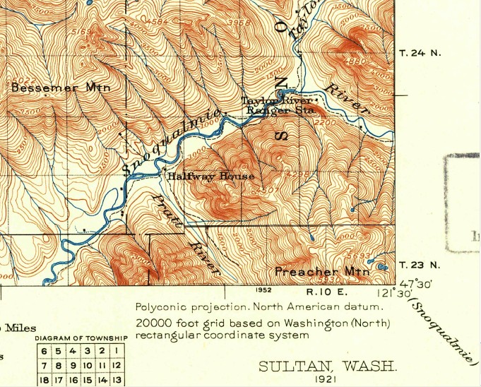
Here is more grist for the Camp Brown discussion mill. See 1921 USGS map below.
"Halfway House" at the Pratt Confluence. Halfway to where? North Bend to Goldmyer?
"Taylor River Ranger Station" Located across the MFK from where the future Taylor River Campground (1950s-70s) would be.
Pre-CCC, the only land route up alongside the MFK is on the south bank.
Camp Brown is located approximately one mile south of Taylor River on the Middle Fork at River Mile 64. It is located in the Bessemer Mt. Place with views into the Rainy Creek Place. The site is proposed to augment facilities at Taylor River by providing additional car parking, river access and a trail connection. (94)
The map, above, is old and depicts the suggested plans, not the reality, but it accurately zeros in on Camp Brown’s location. I have no idea what is actually where now, if there is anything to see at all.
If I end up that way again next summer (pretty likely), it will be on my list of places to check out.
I, also, know nothing about the “Taylor River Campground (1950s-70s)” and the old ranger station mentioned above. More old sites to check out? Further research is required.
Here is the 1960 USGS map of the area…
For more information on the history of the Middle Fork, this is a pretty cool site: