Showing posts with label Colorado Plateau. Show all posts

Sunday, July 30, 2017

Glen Canyon National Recreation Area: Rincon from Space

The astronaut photographs ISS047-E-106206 — ISS047-E-106225 in this mosaic were acquired on May 7, 2016, with a Nikon D4 digital camera using a 800 millimeter lens, and are provided by the ISS Crew Earth Observations Facility and the Earth Science and Remote Sensing Unit, Johnson Space Center. The images were taken by a member of the Expedition 47 crew. The images have been cropped and enhanced to improve contrast, and lens artifacts have been removed. The International Space Station Program supports the laboratory as part of the ISS National Lab to help astronauts take pictures of Earth that will be of the greatest value to scientists and the public, and to make those images freely available on the Internet. Additional images taken by astronauts and cosmonauts can be viewed at the NASA/JSC Gateway to Astronaut Photography of Earth. Caption by Adam Voiland.
https://earthobservatory.nasa.gov/IOTD/view.php?id=88922


NASA Earth Observatory: A Curious Ensemble of Wonderful Features (October 16, 2016):
https://earthobservatory.nasa.gov/IOTD/view.php?id=88922

When John Wesley Powell explored the Colorado River in 1869, he made the first thorough survey of one of the last blank spots on the map. The expedition began in May at Green River, Wyoming, and ended three months later at the confluence of the Colorado and Virgin Rivers in present-day Nevada.
About two months into their journey, the nine men of the expedition found themselves in Glen Canyon. As the men traveled along the serpentine river channel, they encountered what Powell later described in Canyons of Colorado as a “curious ensemble of wonderful features.”
While the walls were not nearly as high in Glen Canyon as they were downstream in Marble Canyon or Grand Canyon, the explorers encountered a labyrinth of overhanging cliffs, hanging gardens, sweeping river bends, and natural arches set amidst a backdrop of colorful buttes and mesas.
“Past these towering monuments, past these mounded billows of orange sandstone, past these oak-set glens, past these fern-decked alcoves, past these mural curves, we glide hour after hour, stopping now and then, as our attention is arrested by some new wonder,” wrote Powell.
...


download large (full resolution) mosaic image (63 MB, JPEG, 11280x20492)


Links


Monday, June 26, 2017

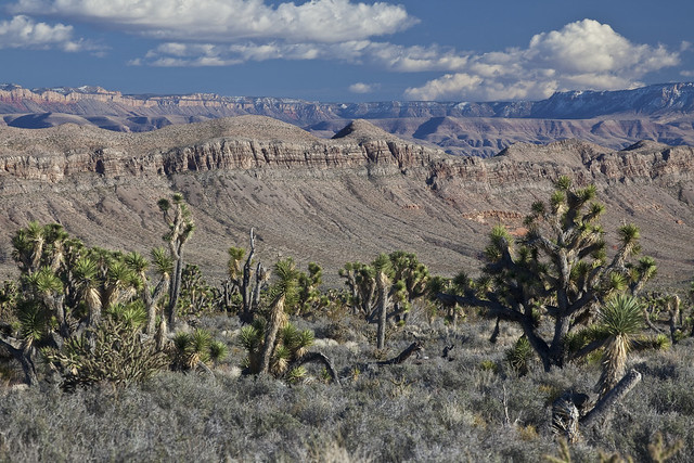
Grand Canyon-Parashant National Monument: 27 Monuments Stop #7

Photo: Bob Wick, BLM California
Taken on August 20, 2009
CC BY 2.0
https://www.flickr.com/photos/mypubliclands/8803445227/in/album-72157633622349991/


https://sites.google.com/view/nationalmonumentsindanger/home


The first in a bit that Brent Rose hit that I haven't been to at all...  Clearly, from his video, this is a rugged place, and the old van from last spring probably wouldn't have been up to the challenge!  She did great in some sketchy situations, but there's only so much one can do with an old Kia Sedona.

This one is jointly managed by the Buearu of Land Managment (BLM) and the National Park Service (NPS).  Hopefully it's remoteness can save it.


According to Wikipedia:

The 1,048,325-acre (424,242 ha) monument is larger than the state of Rhode Island. The BLM portion of the monument consists of 808,747 acres (327,288 ha).[1] The NPS portion contains 208,453 acres (84,358 ha) of lands that were previously part of Lake Mead National Recreation Area. There are also about 23,205 acres (9,391 ha) of Arizona State Land Department lands and 7,920 acres (3,210 ha) of private lands within the monument boundaries.

Wikipedia also answers one of my biggest questions about the monument, "Parashant is derived from Paiute word Pawteh 'ee oasoasant, meaning 'tanned elk hide,' or 'softening of the elk hide.'"

The NPS is currently updating their official park map. The new version will be available in "late 2017."

The major safety update to the map below includes a change in roads to show most of the roads as high clearance/four-wheel drive strongly recommended. The current map indicates many of these roads as being regularly maintained but they are sometimes impassible because of flooding and washouts. Roads in the Parashant are not appropriate for cars because of low clearance and thin tires designed only for paved road use. 
The map also shows water in Grand Wash Bay near Tassi. Grand Wash Bay has been dry for over 10 years. Lake Mead is at about 45% capacity and Grand Wash Bay will not have water for the foreseeable future. The new map will show the current water of Lake Mead correctly.


Grand Canyon-Parashant NM


The monument also contains many archaeological sites, according to the Presidential Proclamation establishing the monument:

Archaeological evidence shows much human use of the area over the past centuries. Because of their remoteness and the lack of easy road access, the sites in this area have experienced relatively little vandalism. Their good condition distinguishes them from many prehistoric resources in other areas. Prehistoric use is documented by irreplaceable rock art images, quarries, villages, watchtowers, agricultural features, burial sites, caves, rockshelters, trails, and camps. Current evidence indicates that the monument was utilized by small numbers of hunter-gatherers during the Archaic Period (7000 B.C. to 300 B.C.). Population and utilization of the monument increased during the Ancestral Puebloan Period from the Basketmaker II Phase through the Pueblo II Phase (300 B.C. to 1150 A.D.), as evidenced by the presence of pit houses, habitation rooms, agricultural features, and pueblo structures. Population size decreased during the Pueblo III Phase (1150 A.D. to 1225 A.D.). Southern Paiute groups replaced the Pueblo groups and were occupying the monument at the time of Euro-American contact. Archeological sites in the monument include large concentrations of ancestral Puebloan (Anasazi or Hitsatsinom) villages, a large, intact Pueblo II village, numerous archaic period archeological sites, ancestral Puebloan sites, and Southern Paiute sites. The monument also contains areas of importance to existing Indian tribes.

Wikipedia also mentions that the monument contains 24 known caves.  A 2005 study revealed these caves contain "two new species of millipede, the first barklouse discovered in North America, a whole new genus of cricket and four new cricket species."


Grand Canyon-Parashant NM


BLM: Grand Canyon-Parashant National Monument (as of June 2017) - PDF


To comment on the monument review process (due July 10, 2017):


Links


27 Monuments:

Website
https://www.27monuments.org

Facebook
https://www.facebook.com/27Monuments

Instagram
https://www.instagram.com/brentdangerrose
https://www.instagram.com/explore/tags/27monuments


BLM: 
National Park Service:

Parashant National Monument

Park Map


Presidential Proclamation Establishing Grand Canyon-Parashant National Monument:

https://www.blm.gov/nlcs_web/sites/style/medialib/blm/az/images/parashant.Par.10414.File.dat/proclamation.pdf


Wikipedia: 

Wednesday, June 21, 2017

Grand Staircase-Escalante National Monument: 27 Monuments Stop #5

Into Long Canyon...
Burr Trail. Grand Staircase-Escalante National Monument. Utah. May 14, 2016.
Copyright © 2017 A. F. Litt, All Rights Reserved
http://www.aflitt.com/grandstaircaseescalantenm
https://sites.google.com/view/nationalmonumentsindanger/monuments/grand-staircase-escalante 


National Monuments in Danger


Take a day off? So far behind in everything! Forget the family, forget other projects... Save the monuments!  Okay, so I might not be as fanatical as that.

But Brent Rose is burning his midnight oil traveling, filming, and editing these videos.  His fifth stop is one of my favorite places in the United States, Grand Staircase-Escalante National Monument, which also happens to be one of the inspirations for the monument review, and one of the monuments in the biggest danger of reduction or elimination.

I'll be sharing a lot of content about this very special place over the next few weeks, but I'll let Rose take over for today.


BLM: Grand Staircase-Escalante (as of June 2017) - PDF


To comment on the monument review process (due July 10, 2017):


Links


Contested National Monuments in Utah House Treasure Troves of Fossils (June 13, 2017)
Paleontologists have found incredible dinosaur diversity at Grand Staircase-Escalante National Monument. What could nearby Bears Ears hold?


Deseret News: Leave Grand Escalante and Bears Ears as they are (May 4, 2017)


Salt Lake Tribune: 

Bears Ears critics' numbers are misleading: A look at early monument sizes (May 30, 2017)

Editorial: Utah’s national monuments have already justified themselves (April 28, 2017)


Leaked documents show Trump administration plans more mining and drilling on public lands (April 11, 2017)


BLM: 

National Monuments in Danger

Bears Ears National Monument: 27 Monuments Stop #4

Valley of the Gods Road and Butte
Bears Ears National Monument. Utah. May 13, 2016.
Copyright © 2017 A. F. Litt, All Rights Reserved
www.aflitt.com/bearearsnm

National Monuments in Danger

https://sites.google.com/view/nationalmonumentsindanger/home


I'm scrambling a bit to get caught up today after taking yesterday off for some family time and for shooting some old ghost towns in southern Washington, so I'll let Brent Rose's work speak for itself on this Bears Ears update...

After his video and photos, I've added some new links to articles on the monument.  For the older links, check out the older posts.


More Bears Ears news...


Bears Ears critics' numbers are misleading: A look at early monument sizes (May 30, 2017)

A comparison of monument designations by Obama and President Theodore Roosevelt show that recent proclamations, on average, are not that much larger than those a century ago, when Congress passed the Antiquities Act, which Roosevelt invoked with great zeal to safeguard the nation's natural heritage from looters, miners and loggers who were then misappropriating the West's resources.   
... 
The average size of Roosevelt's 18 monuments exceeded 85,000 acres; Obama's 31 nonmarine designations averaged 185,311 acres. That amounts to a size ratio of around 2.3-to-1 ­— not the 47-to-1 evoked by Utah lawmakers.
Early monument blockbusters included Alaska's Glacier Bay, designated by Calvin Coolidge in 1925 (1 million acres), and California's Death Valley, designated by Herbert Hoover in 1933 (1.6 million acres). From the beginning, Roosevelt took an expansive approach toward preserving antiquities to include the landscapes that harbored them. Yet one-third of Roosevelt's designation focused on cultural artifacts; the majority protected geological wonders, such as Natural Bridges in the heart of what is now the Bears Ears.
Roosevelt's two largest monuments, Grand Canyon and Mount Olympus (615,000 acres) generated fierce opposition. The U.S. Supreme Court in 1920 affirmed the Grand Canyon designation, while one of Roosevelt's successors shrank Olympus.
http://www.sltrib.com/news/5323050-155/stand-with-bears-ears-or-shrink


BLM: Bears Ears National Monument Map (as of June 2017) - PDF


To comment on the monument review process (due July 10, 2017):

Interior Secretary Ryan Zinke has extended the comment public comment period for Bears Ears to July 10, 2017, the same as the rest of the monuments currently under review.


Links


27 Monuments:

Website
https://www.27monuments.org

Facebook
https://www.facebook.com/27Monuments

Instagram
https://www.instagram.com/brentdangerrose
https://www.instagram.com/explore/tags/27monuments


Department of the Interior: Secretary Zinke Submits 45-Day Interim Report on Bears Ears National Monument and Extends Public Comment Period (June 12, 2017)
https://www.doi.gov/pressreleases/secretary-zinke-submits-45-day-interim-report-bears-ears-national-monument-and-extends


Inside Science: 

Contested National Monuments in Utah House Treasure Troves of Fossils (June 13, 2017)
Paleontologists have found incredible dinosaur diversity at Grand Staircase-Escalante National Monument. What could nearby Bears Ears hold?


The Revelator: The Roots of the Antiquities Act? They’re in Bears Ears (June 15, 2017)


L. A. Times: Op-Ed Shrinking Utah's Bears Ears National Monument would be one more broken promise to Native Americans (June 19, 2017)


Deseret News: Leave Grand Escalante and Bears Ears as they are (May 4, 2017)


Salt Lake Tribune: 

Check out the new book of Native American voices about Bears Ears (June 19, 2017)

Editorial: Zinke leaves Bears Ears dispute unsettled (June 14, 2017)

Bears Ears critics' numbers are misleading: A look at early monument sizes (May 30, 2017)

Editorial: Utah’s national monuments have already justified themselves (April 28, 2017)


Public Land Solutions Whitepaper Highlights Economic Potential for Bears Ears National Monument (April 20, 2017)


BEARS EARS INTER-TRIBAL COALITION CONDEMNS ZINKE RECOMMENDATION TO EVISCERATE BEARS EARS NATIONAL MONUMENT


Leaked documents show Trump administration plans more mining and drilling on public lands (April 11, 2017)
https://thinkprogress.org/blm-priorities-document-91917fc0fca9


BLM: 

BLM on flikr: 


Wikipedia: 


Bears Ears National Monument: Secretary Zinke's Initial Recommendations
Bears Ears National Monument: A Quick Tour of a Monument at Risk
http://rubble.blogspot.com/2017/06/bears-ears-nm-quick-tour.html

Bears Ears National Monument: Video and Links Collection


National Monuments in Danger

Monday, June 19, 2017

Canyons of the Ancients National Monument: 27 Monuments Stop #3

Lowry Pueblo
Canyons of the Ancients National Monument.  Colorado.  May 8, 2016
Copyright © 2017 A. F. Litt, All Rights Reserved
http://www.aflitt.com/canyonsoftheancientsnm 


National Monuments in Danger:

https://sites.google.com/view/nationalmonumentsindanger/home


Brent Rose's third destination, Canyons of the Ancients National Monument in Colorado, is the first on his 27 Monuments project where we overlap, though over a year has passed between our visits.  

It has been a long day, and so, as with the last post on the Organ Mountains-Desert Peaks National Monument, I will let Rose's work speak for now...

I do hope to share quite a bit more about this monument in the very near future.

Finally, I did notice, from the 27 Monuments video below, that oil and gas is an issue with this monument.  Unfortunately, that means this one could be in real danger of elimination.

This might be a moot point, though.  According to the Presidential Proclamation establishing the monument, most of these resources are already leased out for development, and revoking the status would change little from the current status quo.


Because most of the Federal lands have already been leased for oil and gas, which includes carbon dioxide, and development is already occurring, the monument shall remain open to oil and gas leasing and development; provided, the Secretary of the Interior shall manage the development, subject to valid existing rights, so as not to create any new impacts that interfere with the proper care and management of the objects protected by this proclamation; and provided further, the Secretary may issue new leases only for the purpose of promoting conservation of oil and gas resources in any common reservoir now being produced under existing leases, or to protect against drainage.  
https://www.blm.gov/nlcs_web/sites/style/medialib/blm/co/programs/NLCS/CanyonsNM/docs.Par.40740.File.dat/CanyonsNM-PresidentialProclam.pdf


Stop numbah 3: Canyon of the Ancients. #27Monuments #MonumentsForAll I was supposed to edit the video for this and go to bed early. Instead, I ended up hiking in this unbelievable place until 2am. Some of these ruins go back 12,000 years. Video coming soon. To learn about how to save this and 26 other U.S #NationalMonuments under immediate threat, go to 27Monuments.org to find out what you can do. If you have friends who care about these places, tag them in these posts. If you have photos of any of these threatened monuments post them and use the #27Monuments hashtag. They'll automatically be featured on our website. We only have until July 10th to save these places. . For my photo nerdz 📸 🤓: Single exposure with a #sonyalpha #sonya7s. Rokinon 14mm lens. 25 seconds, f/2.8, ISO 3200 . . . #ConnectedStates #vanlife #longexposure #astro_photography #milkyway #milkywaygalaxy #milkywaychasers #newmilkyway #stars #ruins #nativeamerican #nightscaper #nightshooters #nightpics #nightshooterz
A post shared by Brent Rose (@brentdangerrose) on


BLM: Canyons of the Ancients National Monument Map (as of June 2017) - PDF


To comment on the monument review process (due July 10, 2017):


Links


27 Monuments:

Website
https://www.27monuments.org

Facebook
https://www.facebook.com/27Monuments

Instagram
https://www.instagram.com/brentdangerrose
https://www.instagram.com/explore/tags/27monuments


Rubble - National Monuments in Danger:

Canyons of the Ancients
https://sites.google.com/view/nationalmonumentsindanger/monuments/canyons-of-the-ancients

27 Monuments (June 19, 2017)
http://rubble.blogspot.com/2017/06/national-monuments-in-danger-27.html


Sleeping Ute Mountain from Lowry Pueblo (September 23, 2016)
http://rubble.blogspot.com/2016/09/sleeping-ute-mountain-from-lowry-pueblo.html


BLM:

Website
https://www.blm.gov/nlcs_web/sites/co/st/en/BLM_Programs/NLCS/CanyonsNM.html

Map
https://www.blm.gov/nlcs_web/sites/style/medialib/blm/co/programs/NLCS/CanyonsNM/maps.Par.55277.File.dat/CANM_map.pdf

flikr
https://www.flickr.com/photos/blmcolorado/albums/72157664342704112


Wikipedia:

Canyons of the Ancients National Monument
https://en.wikipedia.org/wiki/Canyons_of_the_Ancients_National_Monument

Lowry Pueblo
https://en.wikipedia.org/wiki/Lowry_Pueblo


National Monuments in Danger