
. Gresham, Oregon. December 18, 2011. Test photos with new camera.")
Well, not so much a trail report yet, but a future trail report. This is a trail / area I’ve been meaning to explore for a while.
Actually, I have been near this trail… I took the boys out to hike it a few years back, but about 100 yards in they declared that it was a boring trail and that they didn’t want to take it, so we went elsewhere.
I will admit, we are all a bit spoiled by some spectacular scenery, but these quiet trails are nice too. Especially when they are so close to home.
This evening I finally got around to heading up the Jenne Butte trail, and that led me to think about this other, near by, neglected trail. So I did some research and this is what I found.
I also threw in some material on the Boring Lava Fields since these cinder cones define our local landscape.
City of Gresham : City : Gresham Butte Saddle Trail:
Formerly an old logging road, this lush trail was constructed in 1998 and is set in an upland forest setting and crosses several small tributaries.
Trail features
The trail climbs up and over the saddle between two buttes (Gresham Butte to the north and Gabbert Hill to the south).
The area is abundant in native vegetation, providing a lush, forest experience.
Trailside shoulders have been replanted with native plants such as salal, sword fern, and vine maple.
The trail also connects with the top of Gresham Butte, offering panoramic views of the City.
The buttes are two of nine extinct volcanic lava domes in City limits.Parking and trail access
Street side parking is available on either end of the trail; at Southwest 19th Drive off Towle Avenue and Southeast 19th Drive off Regner Road."

Under the Sky: SE ~ Gresham Butte Saddle Trail:
Fall is a great time to take this trail because of the abundance of deciduous trees. Formerly an old logging road, the trail traverses the saddle between Gresham and Towle Buttes and Gabbert Hill. Pretty much a straight shot through the woods, go out and back for the full mileage, and expect some climbing. In addition to the hills, there's plenty of room to roam the neighborhood streets surrounding the trail for some additional calorie expenditure. There appears to be other trails that branch off from the main trail—we did not take them, but will explore another day. The Springwater Corridor path is also nearby.
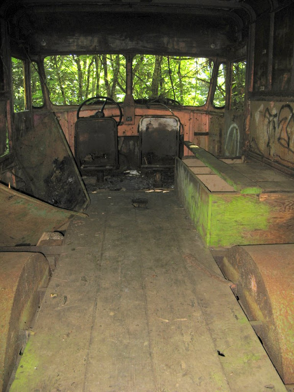
Out of curiosity on the way back, I turned south onto the cross trail. It’s a pretty steep and unrelenting climb up the hill and as you begin to crest you seem to be promised some sort of vista as the sky begins to show through the trees. Alas, all you see is a large water storage tank. On the way back down, I decided to follow a second fork in the trail and discovered this old abandoned delivery vehicle and decided to end the hike at that point and head for home.

"Lost on Gresham Butte" Risleykid, on November 14, 2009, said:
I have learned that the work truck was left over from the Mount Hood Freeway prep work about 48 years ago. The truck was used to move waterlines to make way for the freeway. Interestingly, the City will be moving the waterlines back to a better alignment in the summer of 2010.
East Buttes - Wikipedia, the free encyclopedia:
The East Buttes are made up of several extinct volcanoes in and around Gresham, Oregon, United States, which are part of the Boring Lava Field. The Boring Lava Field became active at least 2.7 million years ago, and has been extinct for about 300,000 years.[1]
The buttes stretch from southeast Portland into Damascus. Included are Gresham Butte (also known as Walter's Hill), Gabbert Hill, and Towle Butte.…
Much of the land on Gabbert Hill was previously designated for a subdivision called Darby Ridge,[2] but was acquired by Metro and the City of Gresham in 2007.
Portland Hikers • PortlandHikers.org: Gresham Butte 5-2-08
More good pictures of the lost truck here.
Where I Walked: Walk 31: Gresham Butte Saddle Trail (5 miles):
Yet another path built around a lava dome (how many are there in this city?). I parked in a residential neighborhood and headed for a Dead End sign. As happens so many times on these walks, right when the road looks like it’s ending, a trail appears magically. This is one of my favorite sights…

Look, someone borrowed my picture! Creative Commons yes, but attribution is necessary. I suppose my unreadable watermark is supposed to count. Unfortunately, this is off of a different trail, the Gresham-Fairview trail and not the Gresham Butte Saddle Trail.
The following vents are in Oregon:
Chamberlain Hill - Elevation 890 feet (271 m)[3]
Cook's Butte - Elevation 718 feet (219 m)[3]
Highland Butte - Elevation 1,594 feet (486 m)[4] (near Beavercreek, Oregon)
Kelly Butte - Elevation 400 feet (122 m)[3] (near the interchange of SE Powell Boulevard and I-205 in Portland)
Larch Mountain - Elevation 4,061 feet (1,238 m)[1]
Powell Butte - Elevation 614 feet (187 m)[5]
Rocky Butte - Elevation 612 feet (187 m)[6] (stone tower with outstanding view of Portland)
Ross Mountain - Elevation 1,380 feet (421 m)[3]
Swede Hill - Elevation 995 feet (303 m)[3]
Mount Scott - Elevation 1,093 feet (333 m)[7][4] (named for Harvey W. Scott)[8]
Mount Sylvania - Elevation 978 feet (298 m)[9]
Mount Tabor - Elevation 630 feet (192 m)[10] (center of a large multi-use Portland city park)
Mount Talbert - Elevation 715 feet (218 m)[11]
TV Hill - Elevation 1,275 feet (389 m)[3]
Walker Peak - Elevation 2,450 feet (747 m)[4]

No comments:
Post a Comment