


I spent a lot of time when I was younger in this area outside of North Bend, Washington. The last couple years, I got to revisit the area and it has changed a lot. New campground and day use facilities, etc… Some of the old roads are closed, which I don’t like, but if it helps to preserve the area, I suppose that is for the best.
When my dad and I first went out there in our big, old orange pick up truck, I was amazed that a place like this existed only minutes from our home in Issaquah. I remember saying, “I can’t believe this isn’t a National Park. It’s almost like Yosemite out there.”


Well, I had never been to Yosemite at that point, I have since, and while the Middle Fork is pretty spectacular, it might not quite be Yosemite spectacular, though for being, like I said, a few minutes from home, it was pretty damn good.

I suppose I am not the only one who felt that way. This year, I found these quotes about the area…
This is from a development plan for the area from the mid-1990s and describes the area as I knew it as a teenager…
http://www.americanwhitewater.org/resources/repository/2220_river_corridor_plan.pdf
The Middle Fork Valley is one of the more significant, close-to-home places in King
County. Often called the “Yosemite of the Cascades,” the Valley is less than one hour drive from over one million people within the Seattle metropolitan area. As a destination, the Valley presents a beautiful, yet mysterious, challenge. There is no managed entry into the Valley, no centrally located orientation point that offers watershed-wide interpretive or wayfinding information, and no wayside exhibits, markers or developed interpretive facilities. (9)
Before our trip out there this summer, looking for trails, I saw another quote that I couldn’t find today mentioning that, if this area was located this close to pretty much any other city than Seattle, it probably would have been a major National Park. However, since Seattle is so spoiled with natural wonderlands in such close proximity, that this area has pretty much been overlooked by everyone.


When my dad and I first stumbled into this valley back in the 1980s, this is what surprised me the most. How nobody seemed to know about it. Well, not the right people, at least. We found it on our Mt. Baker-Snoqualmie National Forest map, a long, long road leading way back into the mountains, and decided to go check it out.
The development report describes the drive as it was back then. The road is a little better maintained these days, but this still pretty much describes the drive today.
It takes approximately 30 minutes to drive the Middle Fork River Road from the
mouth of the Valley to Taylor River. The road is narrow, rough and windy in places,
requiring attentive, slow driving. But the focus is well rewarded. As one enters the Valley,
time slows and a quiet forest of trees encloses the roadway. Ferns, logs and moss thicken the wet forest floor. And the rushing of the River can be heard clearly through the trees.
As one moves upstream, the forest canopy opens and closes. One catches only glimpses of lonely peaks, ridges, and the River. Finally, at the Middle Fork bridge, views up and down the River’s meanders reveal the full, u-shaped figure of the Valley from Bessemer Mountain to Russian Butte.
Beyond the Middle Fork bridge, the rough road leads deeper up the Valley. It widens
and straightens but closes under trees as it moves nearer the River. Now, the Middle Fork is ever present, separated from the road at times only by wetlands and small streams tumbling off of the Valley’s west ridges. Muddy vehicle tracks and narrow spurs leading to the river’s edge are numerous. As the road finally reaches Taylor River, the landscape opens on to young forest and giant old trees, the joining of the Taylor and Middle Fork, and the looming cliffs of Garfield Mountain. (25)
Through the late 1980s and early 1990s, it was pretty “Wild West” out there. Contrary to my first impressions, a lot of people, apparently, knew about the area… The road back there was always busy, but it could be a fairly rough crowd. In fact, later in High School, almost every one I knew learned about the Middle Fork, since this is where most of the major keggers occured, out at Taylor River, as everyone called it.
Again, from the 1990s development report:
Some hiking and boot-built trails, (many familiar to only the most intrepid of hikers),
used and unused logging and spur roads, and a single main road carry recreationists to
high elevation trails and to backcountry and wilderness destinations. Meanwhile, many
visitors experience the river corridor in glimpses from the road. They stop for short visits at locations where the river is visually or physically accessible and shorelands appear safe and unlittered, or at pullouts where parking looks relatively hazard-free. Many of the sites provide excellent river views and relatively easy river access, but some are poorly located and visitor use has resulted in significant stream-side erosion and vegetation damage. All are usually littered with garbage or human waste. Given these conditions, visitors do not generally experience a positive or comprehensive sense of the river or the larger Valley. (9)
Things got even worse, it seems, before they started getting better.
Middle Fork Snoqualmie River: Upstream — Washington Trails Association:
The Middle Fork Snoqualmie River valley has come a long way. Once the playground of loggers and miners, the valley was stripped of many of its resources and then left torn and tattered. Soon came the unsavory characters, making the Middle Fork their own personal dumping ground. Drug users and meth producers fouled the forest with their toxic concoctions. Then came the Middle Fork Coalition, a hard-working group of volunteers who helped the Forest Service clean up the valley while developing plans for its future greatness. Roads were closed, trails were built, garbage dumps were cleaned up. Peace and quiet was restored. Today, the Middle Fork Snoqualmie is a recreationist's dream, and the Middle Fork Trail is one of the best recreational resources in the valley.
Diving out there last year, I was amazed at the changes. Day use areas and a campground. Though, as I said, I was a little frustrated with the Dingford Creek gate. Once, dad and I made it all the way out to the end of the road below Dutch Miller Gap, and I remember that it was pretty spectacular out there. However, I also remember that the road was in pretty rough shape back then.
I don’t ever remember the Taylor River road being open beyond the bridge, but from what I was reading today, it apparently was open off and on for a while through the 1990s, at least. Of course, it is permanently gated now and the road is, rather dramatically, returning to nature.


We spent a couple nights in the forest service campground this summer. Not the first night I’d spent out there, but the first in a real campground. The first night we were there this August, as we were settling in for bed, I got up and locked the van.
The Ex One asked me if that was really necessary since there was only one other group in the entire campground that night (it was a weeknight, the weekend was booked full to capacity). I mumbled something about her not remembering that area like I did, and I locked up.


Apparently, more development is in the works. First up, paving the road out there. I have bitter sweet feeling about this. Yes, it would be nice to get in and out of the area a little quicker and with less washboards and pot holes bouncing us everywhere, but a paved road just means more people.
I suppose the valley isn’t much of a secret place anymore, and more people are inevitable. But I think that is what was fun about the area when I was young. It was a secret place. Of course, there were good things and bad things about that, but it was fun.


Middle Fork Road to be Paved? — Washington Trails Association:
Now the Forest Service and King County have agreed to pave the stretch of the Middle Fork Snoqualmie Road (FR 56) from where the current pavement ends (MP 2.7) to the Middle Fork Campground (MP 12.4). A Memorandum of Agreement (MOA) between the Federal Highway Administration, King County Department of Transportation and the US Forest Service has been completed for $20 million the proposed project.
Camp Brown
Crashing around on the old roads out up the Middle Fork in our old orange pick-up, or later on with my little Blazer, we had a lot of fun driving up random spurs and looking for hidden places. Never found much except for the occasional washout and the joy of having to back a quarter mile down a steep and windy road to a place where we could turn around…

There is a lot of history out there. This was obvious back in the day, but before the internet it was hard to find out much about it. All the woods east of Seattle have a nearly haunted feeling from their heavy use over the years. Logging, mining, etc...
The area I grew up in felt like this. You could sense the ghosts of times long past wandering through the second and third growth forests.
Those woods are now long gone, mowed down one final time and replaced by endless housing developments. But the Middle Fork woods remain, and they too are filled with artifacts and ghostly reminders of a nearly forgotten past.
Working on these pictures earlier, I became curious about the Camp Brown mentioned on this old road sign, miles up a trail now near what used to be the terminus of the Taylor River Road…
Apparently, this might be a pretty old sign… Here are some mentions of Camp Brown:
In 1937 the NBTC abandoned Camp Brown and started to pull the main rail line. The CCC road was built in 1938 and extended to Goldmeyer Hotsprings in 1939. In 1941 the NBTC indicated the intention to stop railroad logging and the rail lines were pulled out in 1942 (it seems highly unlikely according to the most reliable sources that the rails were sold to pre-war Japan as some rumors have indicated). In 1942 the rail line was converted to a truck road.
Old shooting sites to be new rec area - seattlepi.com (2003):
Yesterday, Schrenk and Johnson pointed out one area along the Middle Fork road where a former logging camp called Camp Brown has been transformed into a deep-rutted, mud-holed obstacle course -- with trees as the obstacles. The practice of driving rigs around in the mud -- or in some cases, the river itself -- is called "mudding.”
http://www.nwhikers.net/forums/viewtopic.php?p=774795
Backpacker Joe: There are a few small remains. In the old days when I/we/you had to ford the creek there I remember a could old wooden artifacts. Now that you can walk across the bridge you might head up there a take a look.
...
"1928-29 Railroad extended to 1 mile past Taylor River. Camp Brown is built (named after Robert Brown, civil engineer for laying track on the Middle Fork railroad who was run over and killed by a backing locomotive in 1928)."
mtnresqr: From what I remember as a kid, Camp Brown was a USFS Guard Station alongside Middle Fork road. Like around late 1950's. A small Ranger Station in a wooden cabin. Then the log cabin got rickety or damaged and was torn down. The USFS put a concrete pad down, to park a small camping trailer, for a seasonal USFS place. Maybe around early 1960's.
And, back before that, over on Rainy Creek, on other side of MF river, there was a water works, that provided water for the camp, thru some 7-8 inch wooden water pipe. the remains of that pipe still shows in a few places, by the wire wrapping remaining. Like continuous coils of wire that was used to wrap the wooden pieces to hold it into a pipe. On the far side of Rainy Creek, near the new bridge on the new Pratt Connector trail. That is because in the past, Camp Brown was a fairly large timber company logging camp. Must have had a water pipe system across Middle Fork River.
The location of the concrete pad, is at the wide spot on MF road about three fourths mile before the Middle Fork Trail Head parking lot. This 'wide spot' gets used as a once popular camping spot in Summer. Park cars and wander out an old road to river.lopper: There was a "single-wide" prefab trailer on the slab until the mid 1970's. It was always locked and un-manned during my comings and goings 1968-1974.
Also there was a wall-sized wooden sign-board on the east side of the parking area next to the trailer. I think that the sign listed distances to the main road-accessed trailheads further up the roads east and north. I wonder if anyone has a picture of that sign? It was big....like the one at US10/Denny Creek in the old days.
South of the Guard Station, at the riverside (in the mid 1970s), there was a large stump wrapped with steel cables where a footbridge had once crossed the MFK to the Rainy Cr. Trail. (not to be confused with the wire bridge at the Pratt confluence).
When I worked for the USFS in Wenatchee in 1978, I had a supervisor who had been stationed at Camp Brown for a couple of summers in the late 1950s or early 1960s.…
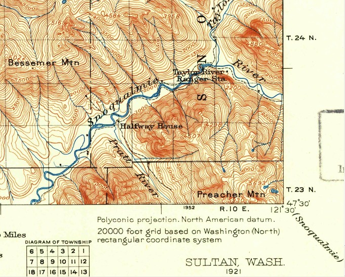
Here is more grist for the Camp Brown discussion mill. See 1921 USGS map below.
"Halfway House" at the Pratt Confluence. Halfway to where? North Bend to Goldmyer?
"Taylor River Ranger Station" Located across the MFK from where the future Taylor River Campground (1950s-70s) would be.
Pre-CCC, the only land route up alongside the MFK is on the south bank.
Middle Fork plan from mid-1990s (http://www.americanwhitewater.org/resources/repository/2220_river_corridor_plan.pdf)
Camp Brown is located approximately one mile south of Taylor River on the Middle
Fork at River Mile 64. It is located in the Bessemer Mt. Place with views into the Rainy
Creek Place. The site is proposed to augment facilities at Taylor River by providing
additional car parking, river access and a trail connection. (94)

The map, above, is old and depicts the suggested plans, not the reality, but it accurately zeros in on Camp Brown’s location. I have no idea what is actually where now, if there is anything to see at all.
If I end up that way again next summer (pretty likely), it will be on my list of places to check out.
I, also, know nothing about the “Taylor River Campground (1950s-70s)” and the old ranger station mentioned above. More old sites to check out? Further research is required.
Here is the 1960 USGS map of the area…

For more information on the history of the Middle Fork, this is a pretty cool site:
http://www.middleforkgiants.com/MFHistory.html
1 comment:
This is a great summary of a lot that has gone on in the Middle Fork for the last 20 years. I'm spend a lot of time out there and more changes are afoot. Excellent post!
Post a Comment