Showing posts with label science. Show all posts

Sunday, November 30, 2014

Glacier Calving from Chasing Ice

http://www.chasingice.com


Related Posts


Wanderers

An amazing little film.  Watch on full screen, if possible!

Wanderers - a short film by Erik Wernquist from Erik Wernquist on Vimeo.

Related Posts

Friday, September 05, 2014

A Steamy Evening on Hell’s Half Acre

A. F. Litt: Yellowstone National Park &emdash; Steamy Evening at Grand Prismatic Spring

Steamy Evening at Grand Prismatic Spring
Midway Geyser Basin.  Yellowstone National Park. August 2, 2014
Copyright © 2014 A. F. Litt, All Rights Reserved

Photo of the Day by A. F. Litt: September 5, 2014
On www.aflitt.com: http://www.aflitt.com/p66748386/e155b12c8

This is the largest hot spring in Yellowstone National Park.  It is 370 feet in diameter and 121 feet deep, which doesn’t sound like much, but when you are standing next to it, it feels much more like a large pond or small lake than a hot spring…  Well, except for the heat and steam pouring off of it! 

The features of the Midway Geyser Basin, all huge, probably felt even bigger after spending the day wandering through the Lower Geyser Basin, which is spectacular and beautiful, but a little more life-sized, so to speak.  The features at Midway feel unworldly…  Like we’ve suddenly been transported, via wooden walkway, from Earth to Io or someplace.

The Grand Prismatic Spring is the third largest in the world.  The only two hot springs larger than it are in New Zealand.  According to the National Park Service, “a description of this spring by fur trapper Osborne Russell in 1839 also makes it the earliest described thermal feature in Yellowstone that is definitely identifiable.”

In 1889, Rudyard Kipling dubbed the Midway Basin “Hell’s Half Acre,” which is certainly a more descriptive name of this place than Midway, which “despite its small size … possesses two of the largest hot springs in the world.”

We hit there at a great time of the day for pictures, but not so great for actually seeing much of the Grand Prismatic Spring or the Excelsior Geyser Crater…  The air was cooling and the steam was thick, adding much to the other worldly feel of the location.

But it was a spectacular place to spend the sunset. 

So spectacular, in fact, that we accidently killed the van’s battery while wandering around up there.  I thought we’d spend a few minutes here; we spent over an hour…  Unfortunately, we were charging up a bunch of gear in the car and I accidently left the headlights on while the boy’s mom and Bella (our dog) were holding down the fort.

Thanks to the kind fellows from Illinois who gave us a jump and got us back on the road!

 http://www.yellowstonenationalpark.com/midway.htm

http://mms.nps.gov/yell/ofvec/exhibits/treasures/thermals/hotspring/grandprismatic.htm

Related Posts

Monday, September 17, 2012

SW Washington Lava Caves

Drove around the Big Lava Bed today and we were wondering about lava tube caves in the area…

Collapsed Lava Tube.  Big Lava Bed.  Skamania Co., Washington.  September 16, 2012.

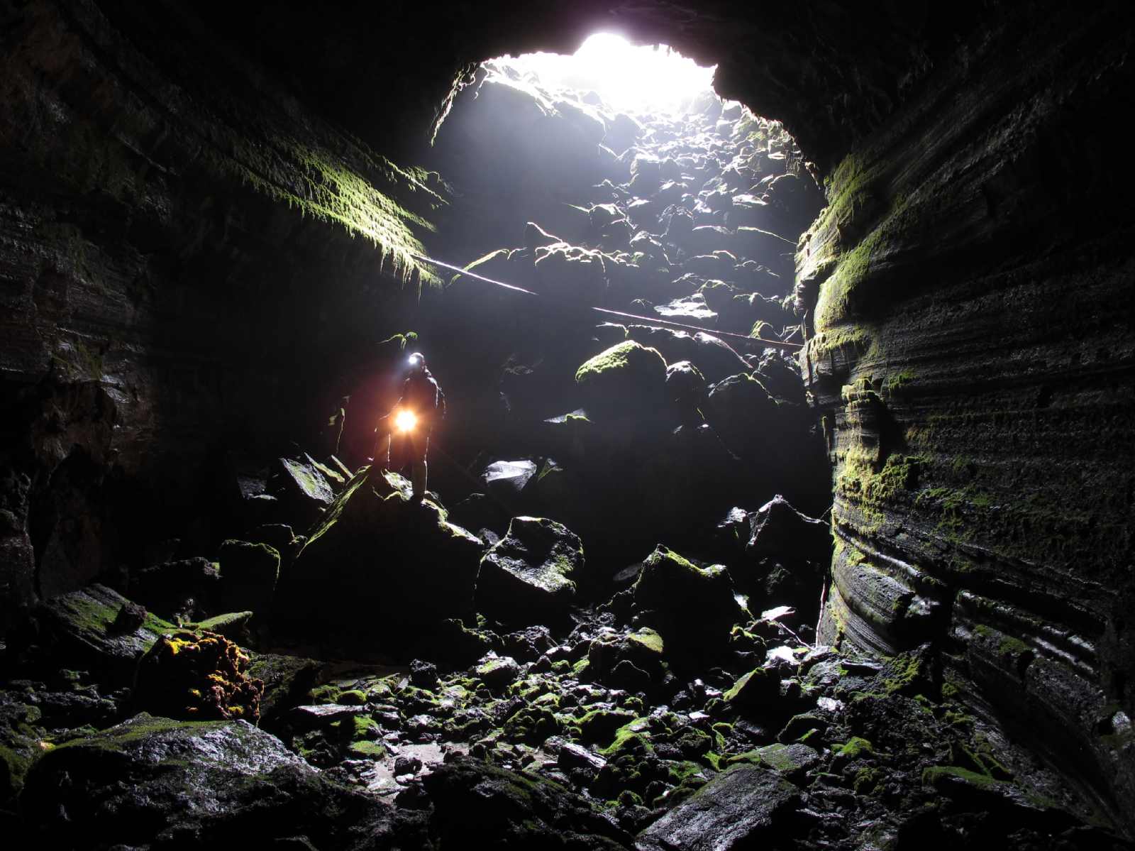
Of course, there is Ape Cave, but that is a bit further away.  Really, I want to know if any have been found associated with the Big Lava Bed flow itself…  We did see a nice caved in tube, but didn’t poke around long enough to find a cave, though it would be surprising if there were not a ton of them.

Lists, links etc. to Trout Lake and Falls Creek caves…

Update September 29, 2012:  Found a link to a pdf of Caves of Washington by William R. Halliday:

https://www.box.com/shared/syg47zjgqu#/s/syg47zjgqu/1/24749920/260009824/1

Trout Lake Caves - Oregon Grotto of the NSS:

Some links to Trout Lake caves.  http://www.goodearthgraphics.com/showcave/wa.html

This area has hundreds of lava caves. There are large caves with 60 foot high ceilings (Cheese cave) to belly crawling caves. Too many of them to name. There are maze like caves like Deadhorse cave, Pickings cave and more. There are Ice caves (Gular Ice cave). Caves with cool formations, lava trenches (Wildcat cave), Natural Bridges and more. Then there are big long caves with lots of breakdown to give you a good work out like Big cave. Then there are caves with cool minerals in them like Happy cave, Slime cave and Metrocal cave.


Indian Heaven Volcanic Field, Washington

http://vulcan.wr.usgs.gov/Glossary/LavaTubes/description_lava_tubes.html


From: Wood and Kienle, (eds.), 1990, Volcanoes of North America - United States and Canada: Cambridge University Press, Contribution by Paul E. Hammond
The Indian Heaven volcanic field is midway between Mount St. Helens and Mount Adams ... Basalt to mafic andesite lava flows range from 0.4 to 24 meters in thickness, whereas andesite flows are up to 90 meters thick. Individual flows extend up to 46 kilometers in length, have areas to 116 square kilometers, and volumes to 1.2 cubic kilometers. Most flows less than 150,000 years of age contain extensive lava tubes, making the Indian Heaven Volcanic Field and important speleological area.

From: Swanson, Cameron, Evarts, Pringle, and Vance, 1989, IGC Field Trip T106: Cenozoic Volcanism in the Cascade Range and Columbia Plateau, Southern Washington and Northernmost Oregon: American Geophysical Union Field Trip Guidebook T106.
The Indian Heaven volcanic field, midway between Mount St. Helens and Mount Adams, is a Quaternary center, chiefly of basalt. ... About 60 eruptive centers lie on the 30-kilometer-long, N10degreesEast-trending, Indian Heaven fissure zone. The 600 square kilometer field has a volume of about 100 cubic kilometers and forms the western part of a 2000-square-kilometer Quaternary basalt field in the southern Washington Cascades ... Pahoehoe and a'a typify the basalt flows; some of the andesite is block lava. Tephra production was minimal, although the basaltic tephra accompanying extrusion of the Big Lava Bed flow has a volume of about 100,000 cubic meters. Big Lava Bed is known for its tubes and for the remarkable microtopography on its surface, which mostly results from inflation of the flow when its feeder tubes clogged.


Falls Creek Cave

Falls Creek Cave entrance photo from Curious Gorge Blog.

#59 Falls Creek Cave « Curious Gorge Blog:

Bring lights, have fun!!       Falls Creek Cave is one of a number of “hidden” caves in the Gifford Pinchot forest, but unlike many, Falls Creek cave is reasonably easy to explore with technical caving gear, nor the need to crawl.  Not many lava tubes allow you to make an underground loop like in Falls Creek cave. Gotta like that!!

del greening Says:
May 14, 2012 at 2:43 pm | Reply

several years ago ,,in a book ( i think ” caves of washington state”) there was a ‘surveyed’ map of the falls creek cave… it is humungus the entrance was listed as having an elevetion of up to sixty feet. the map showed the twists and turns clear to the terminus…very detailed. i have made many trips thru with scouts. a great trip and further east are great places to rough camp near the creek. one thing to remember if you go,,, back in a ways there is a drop of maybe six to ten feet, it dse not hurt to carry a length of rope to tie off above and use as a safety line in passing either up of down,,….

Falls Creek Cave : Trailpedia:

Directions: I-84 East from Portland: 1. Travel east on I-84. 2. Take Exit 44 for Cascade Locks. 3. Take an immediate right after the off-ramp. You will wind around a short on-ramp for Bridge of the Gods. 4. Cross Bridge of the Gods (NOTE: There is a toll). 5. Turn right onto Highway 14 East. You will follow the road through Stevenson, past a pond and toward Carson. 6. Turn left onto Wind River Road (milepost 47.5). 7. Go straight through the four-way stop in Carson to remain on Wind River Road. 8. Turn right onto the second Old State Road (milepost 5). 9. Take the first left onto Panther Creek Road (FS Road 65). You will cross Panther Creek in 4 miles, and pass a quarry in 7.3 miles. 10. Go straight through the “4 Corners” junction (10.8 miles in) to remain on FS 65. 11. Turn left onto FS 67 about 2 miles later; the pavement ends here. 12. Stay right at the fork for FS 6701 in 0.8 miles. 13. Continue 0.8 miles farther past a campground and quarry. 14. Turn right at the sign for Falls Creek Trail 152. There is a small, dead-end set of tire tracks just off the main road that is a good place to park.

http://www.oregongrotto.com/troutlake.shtml

Falls Creek: 633-204. About 6000 total feet with about 4300 feet in the main pain passage. There are three parts of the cave separated by collapse sinks. (AKA: Panther Creek, Lava Caves). See Caves of Washington for full write up.

Salamander Cave

Salamander - lower entrance photo (http://www.oregongrotto.com/gallery/v/washcaves/Falls-Creek/Salamander_Quick_e_mail_view.jpg.html)

No idea where this is but it is near Falls Creek, apparently.  Maybe a part of the same tube system?

Salamander: 633-201

http://www.oregongrotto.com/troutlake.shtml

Salamander Cave

http://www.flickr.com/photos/josh_hydeman/7655078128


Double Eagle Cave

Again, I have no idea where this is but it is near Falls Creek, apparently.  Maybe a part of the same tube system?

But I will say, I don’t like the looks of this…  The caption is “dug open entrance.”

Apparently, it opens up a bit on the inside…

Photos from  http://www.oregongrotto.com/gallery/main.php?g2_itemId=2308

Double Eagle: 633-200: A tight vertical entrance into a nice little cave. Mostly walking.

http://www.oregongrotto.com/troutlake.shtml

Skamaniac / Datus Perry

Photo from http://www.oregongrotto.com/gallery/main.php?g2_itemId=2308

Skamaniac: 633-205 See Datus Perry cave.

Datus Perrys Cave:…part of the Falls Creek Lava Tube System, was reported to Oregon Grotto in early 1968 by Datus Perry, a long-time resident and inveterate cave digger of Carson Washington. Best known for its lava stalactites and stalagmites, parts of the cave were photographed by Charlie and Jo Larson on May 19, 1968. Two photos depicting a two-foot lava stalagmite "before and after being broken," included in the 1980 Oregon Grotto Slide Show, were actually photos of the stalagmite as found (broken) and of it reassembled. In 1975, Oregon Grotto members surveyed 800 feet of the cave before the survey was abandoned because the cave was too cold for "shirt sleeves."  Speleograph trip report by Libby Nieland Vol. 11 page 129. And Underground Express by bill Holmes 18 (3): 27.

http://www.oregongrotto.com/cavehistory.shtml

Mrs. Olson’s Extension

Photo from http://www.oregongrotto.com/gallery/v/washcaves/Falls-Creek/

Olsen Cave

Photos from http://www.oregongrotto.com/gallery/v/washcaves/Falls-Creek/olsencave/

Three Sinks Cave

Photo from http://www.oregongrotto.com/gallery/v/washcaves/Falls-Creek/3sinks/

Three Sinks: At 2,800 feet map length, Three Sinks Cave is the second longest know segment of the Falls Creek Lava Tube System. Cavers learned of the cave from an Oct., 1967, letter from Clay Beal, then a U.S.F.S. Disrtict Ranger, to Bill Halliday which was forwarded to Oregon Grotto. First known cavers to
visit the cave were Charlie and Jo Larson who found it to be a world class example of stream flow, sedimentation and subsequent erosion of pyroclastics in a lava tube.  Oregon Grotto held a Forest Service special use permit for several years; currently the cave enjoys special protection by the Forest Service.       Trip report Speleograph 359 page 8.

http://www.oregongrotto.com/troutlake.shtml


Folgers Cave:

633-213: A segment of the Falls Creek Lava Tube System, named after a Folgers Coffee can found nearby, was first entered in March, 1968, by an Oregon Grotto party. A 1973 map by Rick Pope and Rick Lonergan shows about 2,100 ft (950 ft map length) of moderately sinuous underlain by terminal branches. Mostly breakdown, the cave exhibits some fascinating lava balls and sand castles.    Trip report Speleograph 359 page 8.

http://www.oregongrotto.com/troutlake.shtml


Blister:

633-203 Falls Creek area cave.

http://www.oregongrotto.com/troutlake.shtml

Breakdown Mountain Cave

The cave is named for the prominet breakdown mountains in the cave. The small entrance sink, 8 foot deep, leads through a low opening (4 feet high) to a more spacious cave with 15-25 foot ceilings. Also known as "Lower Falls Creek System" with about 200 feet of passage at 2570 elevation.

http://www.oregongrotto.com/troutlake.shtml

Downdraft Cave

Near the Big Lava Beds. A very nice cave.

http://www.oregongrotto.com/troutlake.shtml

Big Crater caves

AKA The Dog Caves. Goose Lake. Story Cascade Caver Sept. 2010 Vol. 49 #4 Page 5-6 with map.

http://www.oregongrotto.com/troutlake.shtml

Cave Creek Road System:

See story in Speleograph 380 Page 12.

http://www.oregongrotto.com/troutlake.shtml

Dead Horse Cave, Trout Lake

   Dead Horse Cave is no ordinary lava tube cave. It is the most complex, mapped, lava tube cave in the U.S.--so complex that the generic term “lava tube” seems inappropriate. A very popular cave, broadly consisting of the River Passage, Lower Cave, and Masochists Maze, the cave has three known entrances: the lower entrance (which floods occasionally), the upper entrance (also known as the Rat Hole), and a dug entrance near the northeast corner of Masochists Maze (repeatedly dug open and later backfilled, present condition unknown).


   Well known to locals for decades, as with many other caves in the Trout Lake area, cavers were led to the lower entrance of Dead Horse Cave on Nov.5, 1965, by Lyle Ryan, a Trout Lake resident and employee of SDS Lumber Co. The upper entrance was accidentally found by Don and Maylin Nelson who visited the cave with an Oregon Grotto group on Oct.26, 1969. The opening was confirmed as an entrance by Bob Baker, the first person to enter the cave via this opening.


   This cave lies in the path of ground water moving downslope obliquely toward Dead Horse Creek, which it parallels to the north. Water, manifested by pools, broken streams, subterranean fracture springs (and one boiling spring) streams through parts of the cave; then sinks back into the open rock or sediments, and eventually finds its way to the bed of Dead Horse Creek about 400 feet below the cave's lower entrance.
It was four years after learning of the cave's existence before cavers--expecting to map a deserving but small cave--got around to Dead Horse. An Oregon Grotto team began mapping Oct.19, 1969, and was repeatedly amazed by what lay beyond the "small" cave. It just kept on going and going. The lower maze area was not mapped until Oct. 10, 1971. The last major mapping, Mar. 9-10, 1991, logged about 4,500 feet of passage in Masochist Maze (Larson, 2005)

http://www.oregongrotto.com/cavehistory.shtml

Dynamited Cave, Trout Lake

http://www.oregongrotto.com/gallery/v/washcaves/Dynamited_Cave_Oct_1970.jpg.html

When I was starting my caving, back in the Pleistocene as I recall, there
was a report that the sinkhole where the Dynamited entrance is, held a
strange and wonderful lava tube, one with vertical drops in it. This was
before I started the OG and well before the WVG. Early 60's I was in
contact with Cascade G via Halliday and was an Oregon chapter of his Western
Speleological Survey.


The story was, that kids from Troutlake or Stevenson had gone in there,
roped down a pit and when they dropped off the stretchy rope (there was no
"caving" rope back then, and everything stretched hugely under body wt) it
twanged back, well out of reach. Seems hard to believe, as more than one
had to do it, but who knows. They were trapped. To get out, they piled
up a mound of rocks and one was able to grab the rope and climb out
(probably hand over hand, explaining why they all couldn't do it--much harder than
folks think). That kid went for help and the parents came and got the
rest out. They saw the cave as hazardous, and being loggers, had access to
dynamite. So they mined the entrance and brought it down.


Halliday announced he was getting up an effort to open that legendary
cave, and so I headed up there with a couple of my Reed buddies. Bill had a
comealong and we stressed that out pretty good and managed to pull a few
rocks out of the pile, one time the harness slipped off and the weighted cable
came snapping back with great force, narrowly missing us.


That got us a hole you could squeeze decent sized humans thru and we were
in. Sure enough, the legend was true. Pretty amazing to us, back then.
And the rock pile was there to see.


We once, as we were exiting, met some locals coming in to do the
cave....when we said there were vertical drops, one, carrying a gunnysack showed us
what he had in it....a long rope ladder made of hemp rope, and some
"pitons", which were in fact railroad spikes.


When the first gate was put on the cave, it was just an expanding bar/tube
in the squeeze hole. That didn't last long as the locals apparently
didn't like the idea of applying to Seattle for access. I presume someone
drove their log truck tractor up there, ran a log cable from the road to the
gate, and drove away with the gate....leaving a hole you could then walk
thru.
Steve

http://www.oregongrotto.com/cavehistory.shtml

Dynamited Cave: 633-50: One of the longest caves in the Trout Lake area with many vertical drops and levels.  12,345 feet. Dynamited Cave was discovered in Spring, 1958, by Reno and Carl Ziegler, loggers with the Broughton Lumber Co. In Oct., 1958, early exploration began when Carl Nielsen, family members and friends entered the cave as far as the 15-ft drop. Sometime between Oct. 18 and Dec. 6, 1958, the most decisive event in this cave's history occurred when--after five local boys were unable to ascend a 40-ft pit they had dropped on a 3/8-inch rope--the entrance was dynamited, ending exploration of the cave until 1961. Dynamite was employed again in  late 1972 to destroy one of a series of  typically impotent gates, this one some distance inside the cave.
    This widely popular cave is the most mapped cave in the Trout Lake area. Only moderately sinuous in plan view, it is highly complex in profile, having widely varying mutiple levels and abrupt drops.

http://www.oregongrotto.com/troutlake.shtml

Guler / Trout Lake Ice Cave

 #72 Ice Cave Trout Lake « Curious Gorge Blog:

The Trout Lake Ice Cave was known historically as the Guler Ice Cave.  There are other caves in the area, but most of them are on private property, such as the “Cheese cave”.  The Trout Lake Ice Cave is one-of-a-kind in terms of ice formations.  Make a special late-April/early May trip to the Ice cave and you will be blown away!!

Fullscreen capture 9162012 105518 PM.bmp

Related Posts

Thursday, September 13, 2012

More fun with Boring Lava & the Catlin Gabel Lava Tube System in West Portland

Crater erosional breach?  Bobs Mountain.  Washington.  September 19, 2012.

After hiking up to the “crater” at Bobs Mountain today (and looking for it’s missing apostrophe…), I thought I would look around for some more information about this mountain and the Boring Lava Fields in general.  It is surprising how little is really known about them…

Still, after poking around up there today, I am leaning towards the crater being an erosional artifact, maybe a cirque from the Pleistocene and not an actual crater.  It seems to me that a crater that size would not have survived on a volcano this old in this region. (See my earlier thoughts on this topic here… http://rubble.blogspot.com/2012/01/trail-report-bobs-mountain-washington.html)

It’s on the north side of the mountain and it reminds me of a smaller, lower, softer version of the cirque that is Larch Mountain’s “crater.”

John Eliot Allen, in his 1975 paper “Volcanoes of the Portland Area, Oregon” (http://www.oregongeology.com/pubs/og/OBv37n09.pdf), writes that Bobs Mountain may be “a relatively recent cinder cone” with a “crater outlined by an arcurate ridge, …lower on one side as the result of breaching by erosion.”  This does describe what I saw up there today, though I would suggest the entire shallow depression was caused by erosion and just happens to bear the appearance of a typical, younger cinder cone’s crater.

Wizard Island Crater.  Crater Lake National Park.  Oregon.  August 21, 2012.

Remember, even if this is one of the youngest of the Boring cones, we are still talking about a likely age of “50–130 ka,” which still leaves it vulnerable to late Pleistocene glaciation, as is assumed to have created the Larch Mountain crater.  Recent, in this case, is not very recent.

Apparently, though, these ages are still vague, with more research needing to be done.  Perhaps Bobs is a lot younger than we realize, though this does seem unlikely.  But, as Allen writes, “more exact dating of the Boring Lava is urgently needed.”  That was in 1975.  I am not sure what has been done since.

While Bobs’ crater is on the north side, it may be a little low…  In a different article (“Ice-Age glaciers and Lakes South of the Columbia River Gorge” OREGON GEOLOGY, VOLUME 51, NUMBER I, JANUARY 1989 - http://www.oregongeology.com/sub/publications/OG/OGv51n01.pdf), Allen writes that he only assumes that a feature is evidence of glaciation in this area if “the landform is at an elevation above 3,000 ft, it is on an east or northeast slope, and it is one of a group of at least three similar nearby landforms located in similar topographic positions.”  Later on he reiterates that glaciers in this region “rarely extended down below 3,000 ft in elevation.” 

Since Bobs is significantly lower than 3,000 feet (2110 feet), I suppose I still have to allow for the possibility that Bobs is like Black Butte, near Sisters in central Oregon, an ancient volcano that appears to be a recent one.  However, since the two peaks exist in such different locations, and since Bobs sits in a region that did experience significant erosion from local, alpine glaciers during the Pleistocene, and since it is unlikely that Bobs is less than 15,000 years old, I still have a hard time believing that erosion would not have been the principal cause of this feature…

Again, from Allen, discussing features such as the Larch Mountain cirques, “It is probable that most of [the glacial features on peaks across the Columbia from Bobs] described here were results of the last Vashon or Pinedale glaciation (Crandell , 1965), which culminated 15,000 years ago.”

Allen, 1975, Volcanoes of the Portland Area, Oregon: State of Oregon, Department of Geology and Mineral Industries, The ORE-BIN, v.37, no.9, September 1975 

Geology of Washington - Portland Basin:

South of the Puget Lowland and southwest of the southern Cascade mountains, the Portland Basin marks the northern terminus of the Willamette Lowland of Oregon. In Washington, the northern portion of the Portland Basin is characterized by the low topographic relief of western Clark County.

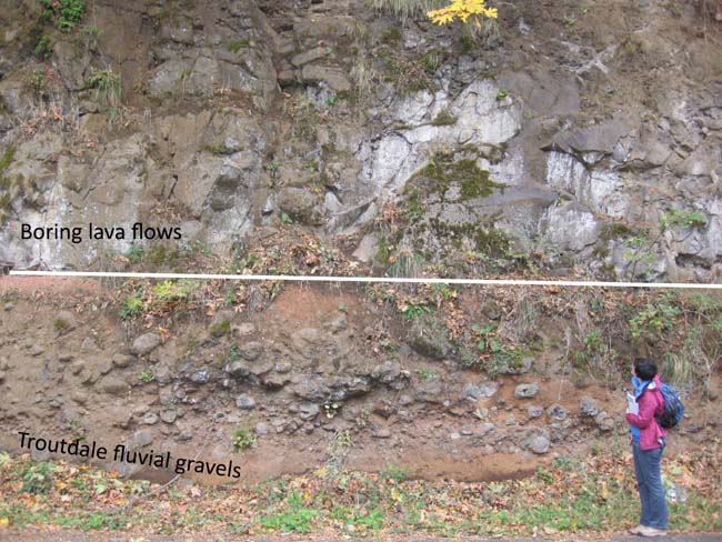
Both upstream and downstream from Vancouver, at the edge of the basin, there are exposures of Columbia River basalt. Within the basin itself, the basalt units lie more than 1,000 feet below the surface. Starting during the Miocene and continuing through the Pliocene, the basin was filled by sediments of the ancestral Columbia River. Named the Troutdale Formation, these deposits can be divided into two general parts: a lower gravel section containing pebbles and cobbles that were derived from the Columbia Basin and the Okanogan Highlands, and an upper section that contains vitric volcanic glass (hyaloclastic) sands. The hyaloclastic sands owe their origin to Cascade Range Simcoe Volcanics flowing into the Columbia River, explosively quenching, and then being redeposited downstream in the Portland Basin as sand. A volcanic breccia subunit of the Troutdale Formation, representing a lahar, has been mapped near Woodland, Washington.

Deposition of the Troutdale Formation was followed by a period of Boring Lava volcanism 2.6 to 1.3 Ma. Centers of extrusive activity have been documented around the margins of the Portland Basin. This volcanism was associated with faulting and structural deformation of the Troutdale Formation and further depression of the Portland Basin.

Lastly, as the glacial Lake Missoula catastrophic floods burst out of the Columbia River Gorge 12,700 to 15,300 years ago, the waters ponded in the Portland Basin. Backwaters caused the deposition of well-sorted sand, clay, and gravel.

NOVA Geoblog: Boring Volcanic Field, Oregon:

Some nice pictures of the different layers…  Troutdale Formation, Boring Lava, etc.
The Boring Volcanic Field of the Portland-Vancouver area, Oregon and Washington: Tectonically anomalous forearc volcanism in an urban setting:

Although the character of volcanic activity is typical of many monogenetic volcanic fields, its tectonic setting is not, being located in the forearc of the Cascadia subduction system well trenchward of the volcanic-arc axis. The history and petrology of this anomalous volcanic field have been elucidated by a comprehensive program of geologic mapping, geochemistry, 40Ar/39Ar geochronology, and paleomag-netic studies. Volcanism began at 2.6 Ma with eruption of low-K tholeiite and related lavas in the southern part of the Portland Basin. At 1.6 Ma, following a hiatus of ~0.8 m.y., similar lavas erupted a few kilometers to the north, after which volcanism became widely dispersed, compositionally variable, and more or less continuous, with an average recurrence interval of 15,000 yr. The youngest centers, 50–130 ka, are found in the northern part of the field. Boring centers are generally monogenetic and mafic but a few larger edifices, ranging from basalt to low-SiO2 andesite, were also constructed.

Portland Hikers • View topic - A Bunch of Boring Volcanoes:

I did know know this about Kelly Butte.  This might be next on my list to explore…

Kelly Butte

Where: S.E. 103rd Avenue, off of Division

On Portland Hikers, we explore abandoned trails, but what about an abandoned park? You park at a rusting gate and walk up a paved road to the former Kelly Butte Civil Defense Center, carved into the middle of the hill bunker-style. The Center was built in 1956 to act as command center in case of nuclear attack. It later became the 9-1-1 emergency dispatch center, but in the mid-90s was completely abandoned and vandalized. Now a massive slope of bulldozed dirt covers the entrance. A great horned owl flapped away from the entrance when I visited here last. On top of the Center is a meadow that used to host park amenities like picnic tables. A trail leads around and over the top of the butte through woods of Douglas-fir, hemlock, and vine maple and thickets of hawthorn and snowberry. You can walk west to get views to Portland’s downtown and then continue down towards Powell to the large water tank at the southwest corner of the “park.”

RenderWidget 9132012 104934 PM

My neighborhood, a long time ago?  Lava Cast Forest Trail.  Newberry Volcanic National Monument.  Oregon.  August 19, 2012.

The other find of the evening’s search was the existence of Lava Tubes in Portland.  This is one of the things I was curious about.  A few weeks ago, standing on a 7000 year old lava flow in central Oregon that ran between two buttes that look like they could have been transported from my neighborhood, I started wondering if there were some buried lava flows and other fun volcanic artifacts in the area.  Well, there are a few, including at least one lava tube, the Catlin Gabel Lava Tube System.
AVPageView 9142012 11124 AM

AVPageView 9142012 11228 AM.bmp

According to yet another article by Allen (“The Catlin Gabel Lava Tubes of West Portland, Oregon: Remnants of a Plio-Pleistocene Cave System” http://www.vulcanospeleology.org/sym03/ISV3x06.pdf), the system is the oldest found in Oregon and is probably (just probably) completely caved in…

First, there’s a lava flow running next to (and under) the Sunset Highway?  Yep… But it’s buried.  “Recent erosion has modified the original surface expression of the lava, and a mantle of Portland Hills Silt as much as 30 feet thick has further masked the surface.”

Apparently the lava tube was discovered during excavations during St. Vincent hospital’s construction.  That section was collapsed and filled with rubble.  But is the whole thing?  Who knows…  I couldn’t find any more recent research than Allen’s 1974 paper. 

He writes:

Although the cross section (Figure 3) shows segments of the tube still intact, an alternate possibility exists – the entire tube system may have collapsed.  In that event, the tubes would consist of channels filled with the debris of the collapsed roofs.  According to R. J. Deacon (Shannon and Wilson 1968), the “rubble-filled channels” beneath the hospital site were masked by undisturbed layers of ash and silt.  This indicates that the roof of the two tubes at that location may have fallen in before the ash and silt were deposited.  If this alternative is valid, it has important engineering implications: those structures such as Catlin Gabel School, that directly overlie the projected course of the tubes, would be in less danger of collapse.

While there are, so far, “no visible openings” to any surviving sections of the tube system, there are five, closed collapse depressions.  Usually, this is the way in.  However, these caves are so old, I wonder how noticeable they even are today.

Collapse depression and lava tube entrance.  South Ice Cave.  Central Oregon.  August 18, 2012.

Allen describes the locations of these tubes and I was able to locate the first three, I think, in Google Earth.

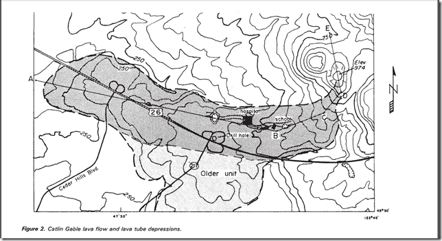
Along the center of the [lava flow’s] arc, within a distance of 6,000 feet, are five closed depressions.

From east to west, the five depressions are as follows: The first (55 feet deep and 500 feet across) lies just east of Catlin Gabel School; the next two depressions (35 and 45 feet deep, 100 and 200 feet across) lie just west of the school; the fourth (30 feet deep and 400 feet across) is north of the interchange of Highway 217 with the Sunset Highway; and the fifth depression (50 feet deep, 150 feet across) lies just north of Sunset Highway and 1,000 feet east of the Cedar Hills Bloulevard interchange. (See USGS Linnton 7-1/2 minute topographic quadrangle).

I am not sure how accurate the Google Earth elevation data is, but it appears that the first collapse depression is now the Catlin Gabel School’s parking lot.

RenderWidget 9132012 93911 PM

While all five depressions are visible on the 1961 USGS map…

image

…only three depressions are visible on the most recent USGS map.

image

Another bit of exploring I want to take on in the next few days…  To go and see what is left of these depressions!

Related Posts

Tuesday, June 26, 2012

Space Shuttle Program: Images, Vehicles, & Space Flights By Year

For our summer studies, the big one and I are going over the history of space exploration…


Challenger (OV-099) started life as the Structural Test Article (STA-099)

U. S. Space Shuttle Program – 1972 – 2011

  • Program officially launched in 1972
  • Planning discussions since 1969
  • 1st reusable spacecraft
  • Originally planned to have 50 flights per year
  • Planned to be a cheaper method of reaching low Earth orbit, this did not pan out for NASA.
  • Crew: 7 astronauts
  • Total Missions:
    • 135 flights
      • 1981-2011
    • 2 lost spacecraft
  • Five Shuttles were built to maintain a fleet of four operational vehicles
  • Program ended in 2011


Enterprise - OV-101 - 1977

· Flights: 5 solo atmospheric test flights

· Years in service: 1

· Days in space: 0

· First solo flight: August 12, 1977

· Location of decommissioned spacecraft: Intrepid Sea, Air & Space Museum, New York City, New York.

· Prototype vehicle not designed for space flight

  • Launched from Boeing 747 Shuttle Carrier Aircraft
  • Constructed without engines or a heat shield
  • Used for glide-approach and landing tests
  • Later used for spare parts for operational shuttles

· Originally named Constitution, but the named was changed after a petition movement by Star Trek fans.

Columbia – OV-102 – 1982-2003

· Flights: 28

· Years in service: 21

· Days in space: 300

· First Flight: April 12, 1982 (20th Anniversary of First Manned Spaceflight)

· Final Landing: Breaks up on Re-entry, February 1, 2003

· Prototype design that was heavier than later shuttles

Challenger – OV-099 – 1983-1986

· Flights: 10

· Years in service: 3

· Days in space: 62

· First Flight: April 4, 1983

· Final Landing: Explodes on Launch, January 28, 1986

· Built as Structural Test Article (STA-099) and later converted to be a fully operational vehicle

Discovery – OV-103 – 1984-2011

· Flights: 39

· Years in service: 27

· Days in space: 365 (One Full Year)

· First Flight: August 3, 1984

· Final Landing: March 9, 2011

· Location of decommissioned spacecraft: Steven F. Udvar-Hazy Center, an annex of the Smithsonian Institution's National Air and Space Museum, in Virginia.

· “Discovery flew all three "return to flight" missions after the Challenger and Columbia disasters.” (Wikipedia)

Atlantis – OV-104 – 1985-2011

· Flights: 33

· Years in service: 26

· Days in space: 306

· First Flight: October 3, 1985

· Final Landing: July 21, 2011

· Location of decommissioned spacecraft: Kennedy Space Center Visitor Complex, Florida.

· Last shuttle in space: July 8 – 21, 2011

Endeavour – OV-105 – 1992-2011

· Flights: 25

· Years in service: 19

· Days in space: 296

· First Flight: May 7, 1992

· Final Landing: July 21, 2011

· Location of decommissioned spacecraft: California Science Center in Los Angeles, California

  • · Built as replacement for Challenger
    • “NASA chose to build Endeavour from spares rather than refitting Enterprise or accepting a Rockwell International proposal to build two shuttles for the price of one of the original shuttles, on cost grounds.” (Wikipedia)


U.S. Space Shuttle Flights - By Year

Year

Flights

Milestones

1981

2

Columbia - 1st Flight - April 12, 1982 (20th Anniversary of First Manned Spaceflight)

1982

3

1983

4

Challenger - 1st Flight - April 4, 1983 (1st U.S. Spacewalk in 9 years)

1984

5

Discovery - 1st Flight - August 3, 1984

1985

9

Atlantis - 1st Flight - October 3, 1985

1986

2

Challenger explodes on Launch: January 28, 1986

1987

0

1988

2

1989

5

1990

6

1991

6

1992

8

Endeavour - 1st Flight - May 7, 1992

1993

7

1994

7

1995

7

1996

7

1997

8

1998

5

1999

3

2000

5

2001

6

2002

5

2003

1

Columbia breaks up on Re-entry: February 1, 2003

2004

0

2005

4

2006

3

2007

3

2008

4

2009

5

2010

3

2011

3

Discovery - Final Landing - March 9, 2011; Endeavour - Final Landing - June 1, 2011; Atlantis - Final Shuttle Landing - July 21, 2011


Related Posts

Monday, May 07, 2012

Supermoon 2012

"Supermoon." Gresham, Oregon.  May 5, 2012."Supermoon." Gresham, Oregon.  May 5, 2012."Supermoon."  Gresham, Oregon.  May 5, 2012.  Photo of the Day, May 5, 2012"Supermoon." Gresham, Oregon.  May 5, 2012.

Deflated Supermoon | Bad Astronomy | Discover Magazine:

This amazing shot was taken by astronaut André Kuipers from the International Space Station on May 5, 2012, as the perigee full Moon set behind the Earth’s limb. The Earth’s atmosphere bends light from the Moon, acting like a lens, pushing the bottom part of the Moon up into the top.

Dropping a dime on the Moon | Bad Astronomy | Discover Magazine:

So, tonight is the so-called Supermoon, when the Moon happens to be full at the same time it’s at perigee, the point in its orbit closest to the Earth. This makes it somewhat larger and brighter than normal, and that’s getting a lot of attention in the press. I pointed out a few days ago that in reality, you almost certainly won’t notice the difference between this full Moon and any other, mostly because the difference is small, and our eyes and brain are terrible at judging things like that without something to directly compare it to.

The Supermoon stuff? AGAIN? | Bad Astronomy | Discover Magazine:

Sigh.

You may’ve seen some folks writing about this weekend’s so-called Supermoon. I suppose I’m not surprised, but it’s still irritating. Why? Because it’s just hype (and to get this out of the way immediately, will have no real effect on the Earth, either). Here’s the scoop.

This weekend, on the night of May 5/6, the Moon will be full. This happens every 29 days or so when the Moon is opposite the Sun in the sky, and we see its face fully illuminated.

As it happens, the Moon’s orbit is elliptical, and so sometimes the Moon is a bit closer to the Earth than other times. Every now and again the Moon is full when it’s also closest to Earth — the point in its orbit called perigee. May 5th is one of those times.

Kryptonite for the supermoon | Bad Astronomy | Discover Magazine:

If you believe the mainstream media, you might think this weekend’s "supermoon" will cause earthquakes, volcanoes, bad weather, halitosis, dust bunnies, and hangnails.

Guess what I think of this idea! Hint: check the name of my blog. Got it? Good.

Supermoon Skeptic Check | Bad Astronomy | Discover Magazine:

Every now and again I chat with astronomer Seth Shostak about some astronomical skullduggery as part of the SETI radio show "Are We Alone". The segment is called Skeptic Check, and the latest is now online, where Seth and I apply a little kryptonite to the idea of the "supermoon" causing earthquakes.

Why does the Moon look so huge on the horizon? | Bad Astronomy | Discover Magazine:

If you’ve ever seen the Moon rising over the horizon, looking so fat and looming that you felt like you could fall right into it, then you’ve been a victim of the famous Moon Illusion. And it is an illusion, a pervasive and persuasive one.

So, how does this thing work? Ah, step right up.


Related Posts