Showing posts with label Columbia River Gorge National Scenic Area. Show all posts

Saturday, July 23, 2016

Antique Auto Tour on the Columbia River Highway

Rowena Crest, Historic Columbia River Highway (2014)
Columbia River Gorge National Scenic Area.  Oregon.  July 15, 2014.
http://www.aflitt.com/2014antiqueautotour
Copyright © 2014 A. F. Litt, All Rights Reserved


Photo of the Day by A. F. Litt: July 23, 2016


Today is the Friends of the Historic Columbia River Highway's annual Antique Auto Tour. Since it is the centennial of the HCRH this year, instead of traveling back and forth from the Western Antique Aeroplane & Automobile Museum (WAAAM) to Rowena Crest, they will be driving from Troutdale to the Columbia Gorge Discovery Center today, with a lunch stop at Marine Park in Cascade Locks.

This photo, from the 2014 tour, is not new to the world.  It's been bouncing around for a couple years, but this is the first time it's been featured as a Photo of the Day.


(Yes... If you get to the end, you'll notice that the film has been delayed a bit, and the web shorts have been paused for a bit...)


Links


Friends of the HCRH: 2016 Antique Car Tour

Friday, November 27, 2015

Latourell Into the Ice, and what the heck is this "Photo of the Day" stuff all about anyway?!?


Latourell Into the Ice (2013)
Latourell Falls. Oregon. December 10, 2013
Copyright © 2015 A. F. Litt , All Rights Reserved


Photo of the Day by A. F. Litt: November 27, 2015

I realized that a lot of folks might not know what these "photos of the day" posts are all about for me. Essentially, my rules, set by myself, for myself, are to post a previously unedited, unreleased photo as often as possible (every work day is a goal, though possibly one that is unobtainable at this point) and to try to write a line or two, at least, relating to the photo (usually), as well...

As for frequency, I want to keep this rolling, so I am not holding myself to posting each and every day, lest I get discouraged and decide that I am just too busy at this time to continue with this "project," and recently it seems like posts are the exception, not the rule, but I stumble along anyway... I've abandoned this project for long periods in the past for that very reason and I don't want to do that again right now.

This all really started back in 2011 as a way for me to force myself to work on photography every day. I was much better about posting most days back then, but as other ventures picked up, and as family life went through a busy and complicated few years, I set the project aside for a couple years.

It was feeling like a burden, and I felt like I'd accomplished most of the goals I'd set for myself with the project, which at the time involved working every day on digital photography (most of my serious work before was done with black and white film in these places called "darkrooms," not on computers), and to establish myself somewhat as a photographer.

The same rules applied back then, posting a previously unedited, unreleased photo, but without the writing component which is a new addition to the 2015 incarnation of this project...

Aside from feeling I'd met a lot of my goals back in 2012, and general busyness in other departments, another big reason why I abandoned the project for awhile was that I found myself rushing the work too much, and that I was not taking the time to select great photos (ones I love, at least) and that I was rushing the edit on them.

So, rather than flooding everyone with sub-par work, I thought it was best to pull the plug on the endeavour for a while.

Earlier this year, though, I realized that I was spending a tiny percentage of my time working on photography outside of the stills for the Recreating the HCRH project, which tend to be more survey oriented rather than artistic, by nature, and I felt that I needed to start forcing myself to spend some time working on my still photography again. Plus, I had several years of photos sitting on my hard drive collecting many layers of digital dust, and it seemed as though those shots might never make it out into the world without returning at least some of my focus back towards still photography.

Back in January, at the dawn of 2015, I tried to relaunch this project. I really only made it a few days, though, before the video work piled up and I found myself feeling like it just wasn't the right time to re-launch the POTD. But the photos were still piling up, and the work on photography still wasn't happening...

A couple months ago, though, I started feeling almost caught up, so I tried again, this time changing the expectations on myself away from rigidly posting every day to posting as much as possible, and that is where we are now. I post if I have time and I find a photo I like. I skip it if nothing is speaking to me or if I just do not have time. This should keep the quality somewhat decent (no guarantees... My taste, not yours! And sometimes I do post photos that have more sentimental value than artistic value, but then it will be explained in the written part of the post), and it lessens the risk of me abandoning the project all together due to feeling like I don't have the time to put the proper effort in.

Because of that, sometimes it will truly be the photo of the day, sometimes the photo of the week, sometimes the photo of the every once in awhile, but by giving myself the flexibility to post like that, hopefully I will posting more than a handful of shots every year.  I am still calling it the "Photo of the Day," but it might not happen every day.  It seems the right name for a project like this and I do hope to be consistently posting more than once a week, so...

For today's photo, I am revisiting the icy winter of 2012 / 2013... There was not much snow, really, but there was a lot of ice around the Gorge's falls, and they were spectacular. I've got a few of Multnomah that have never been posted from this trip that will emerge at some point, but I decided to post one up from Latourell. I've put a few of the shots from day at Latourell out before, but I was never happy with the edits. Who knows? I may hate this one too, on later review, but I wanted to take another swing at getting a photo that I liked out into the world from this set.

That is it for today. I'll be back tomorrow, or next week, or in a couple weeks... But, because of the new approach to this, I am, at a minimum, confident that I'll be posting again, sooner rather than later.

Tuesday, November 03, 2015

Oneonta Falls

A. F. Litt: Public - Not On Site &emdash; Oneonta Falls (2015)

Oneonta Falls (2015)
Columbia River Gorge National Scenic Area. Oregon. August 17, 2015
Copyright © 2015 A. F. Litt, All Rights Reserved
#HCRH http://www.recreatingthehcrh.org http://www.aflitt.com

Photo of the Day by A. F. Litt: November 3, 2015

Back on it after being super busy preparing some film festival submissions and fighting the worst cold I've had in years...  Not much time left for anything else between the two!

Just a plain old waterfall shot of Oneonta Falls from last summer.  I'd love to get back there when that thing was really going, but I have no idea how to do that safely!  Makes me cold just thinking about it...


Monday, October 12, 2015

Flower on Abandoned Columbia River Highway

A. F. Litt: Eagle Creek to Cascade Locks &emdash; Flower on Abandoned Columbia River Highway (2014)

Flower on Abandoned Columbia River Highway (2014)
Abandoned HCRH Fragment. Near Eagle Creek. Oregon. April 20, 2014.
Copyright © 2015 A. F. Litt, All Rights Reserved


Photo of the Day by A. F. Litt: October 12, 2015

Just something blooming along a permanently abandoned fragment of the HCRH...

#HCRH http://www.RecreatingTheHCRH.org
http://www.aflitt.com

Friday, October 09, 2015

Forgotten Highway

A. F. Litt: Herman Creek Road to Wyeth &emdash; Forgotten Highway (2013)

Forgotten Highway (2013)
Fragment of Highway Above I-84, Cascade Locks to Wyeth - Eastbound
Historic Columbia River Highway. Columbia River Gorge National Scenic Area. Oregon. October 20, 2013.
© A. F. Litt


Fragment of Highway Above I-84, Cascade Locks to Wyeth - Eastbound
Historic Columbia River Highway. Columbia River Gorge National Scenic Area. Oregon. October 20, 2013.

Photo of the Day by A. F. Litt: October 9, 2015

A very forgotten section of the old Columbia River Highway between Cascade Locks and Wyeth.


#HCRH

Tuesday, October 06, 2015

Shell Rock Mushroom

A. F. Litt: Wyeth to Shellrock &emdash; Mushroom Along Future State Trail Route (2013)

Mushroom Along Future State Trail Route (2013)
Wyeth - Shellrock, Oregon. October 11, 2013.
Copyright © 2015 A. F. Litt, All Rights Reserved


Photo of the Day by A. F. Litt: October 6, 2015

Okay, missed two weekdays right out of the gate, but I'll get back into the swing of this soon enough. Anyway, I saw this one growing along the future HCRH State Trail route between Wyeth and Shellrock Mountain near the old ruins of Shell Rock, OR.

#HCRH www.RecreatingTheHCRH.org

Monday, April 06, 2015

Wahclella Blowin' In the Wind

A. F. Litt: Route 2 - John B. Yeon State Park to Moffett Creek &emdash; Wahclella Blowin' In the Wind (2013)

Wahclella Blowin' In the Wind (2013)
John B. Yeon State Scenic Corridor. Oregon. May 19, 2013. 
Copyright © 2015 A. F. Litt, All Rights Reserved

Photo of the Day by A. F. Litt: April 6, 2015

Sorting through some older photos from the Columbia River Gorge for my documentary on the Historic Columbia River Highway (www.RecreatingTheHCRH.org), I ran across this shot and thought it was an interesting one... It's a little amazing that even back in a ravine like this, the wind can be strong enough to blow a falls of this size as much as it does.

Friday, April 03, 2015

Hood Over the Gorge

A. F. Litt: Hood River &emdash; Hood Over the Gorge (2015)
Hood Over the Gorge (2015)
Columbia River Gorge National Scenic Area. Washington. March 16, 2015
Copyright © 2015 A. F. Litt, All Rights Reserved


Photo of the Day by A. F. Litt: April 3, 2015

Mt. Hood was doing some neat things in the sunset light the other day while I was out filming for www.RecreatingTheHCRH.org.

Tuesday, March 31, 2015

Cabin Creek Falls and Still River

A. F. Litt: Lindsey Creek to Starvation Creek &emdash; Cabin Creek Falls and Still River (2015)

Cabin Creek Falls and Still River (2015)
Columbia River Gorge National Scenic Area. Washington. March 26, 2015
Copyright © 2015 A. F. Litt, All Rights Reserved

Photo of the Day by A. F. Litt: March 26, 2015

It's been awhile since I've posted a photo of the day, but I took this one while out working on www.RecreatingTheHCRH.org and really liked it, for what it is...


Saturday, January 03, 2015

Misty Gray Day on the Historic Columbia River Highway

A. F. Litt: HCRH State Trail - John B Yeon State Park to Moffett Creek &emdash; Beacon Rock and Old Utility Pole from New Trail

Beacon Rock and Old Utility Pole from New Trail
HCRH State Trail. September 15, 2013
Copyright © 2014 A. F. Litt , All Rights Reserved

Photo of the Day by A. F. Litt: January 3, 2015

I don’t have much time today, so I am not posting a “new” picture, but one that has been on the Recreating the Historic Columbia River Highway site for a month or so…  I first posted it there while I was on break from the Photo of the Day, but I almost went ahead and did a one off POTD post at the time, I liked this photo so much.

It is shot from the new HCRH state trail looking down towards actual location of the old highway, with one of the few old utility poles that still mark the course of the original route.  This was one of the grayest of drizzly Oregon autumn gray days, but it was very nice.  The new State Trail was not officially open yet (traffic was allowed on this one weekend only for the dedication ceremonies) and the final small details were still under construction. 

Being late in the day on Sunday, I had the whole trail to myself, and it was a very nice walk that afternoon, alone in the mists, with the peaks "...like sentinels in the Gorge of the Columbia. The clouds play[ing] 'hide and seek' around their heads, and the eagles mak[ing] their nests among the crags." 

For more information: http://www.recreatingthehistoriccolumbiariverhighway.org/john-b-yeon-state-park-to-tanner-creek

On www.aflitt.com: http://www.aflitt.com/hcrh-statetrail-yeontomoffett/e38762c64

On 500px: https://500px.com/photo/94510025/beacon-rock-and-old-utility-pole-from-new-trail-by-a-f-litt

Related Posts

Thursday, January 01, 2015

An Icy End to 2014

A. F. Litt: Columbia River Gorge National Scenic Area &emdash; Icy Horsetail On New Year's Eave, 2014

Icy Horsetail On New Year's Eve, 2014
Historic Columbia River Highway. December 31, 2014
Copyright © 2015 A. F. Litt, All Rights Reserved

Photo of the Day by A. F. Litt:  January 1, 2015

Well, it’s a new year and it’s time to start up the POTD again.  I could discuss plans for the year, plans for the POTD project, plans for the Recreating the Historic Columbia River Highway project, plans for photography and filmmaking, plans for my family…  All swirling through my head. 

But it is a new year and who knows what God will bring us, so instead, a nice picture from the frozen Gorge yesterday. 

Time to watch some football.  There will be more time for all of this other stuff later.

Happy New Year!  Make it a great one!

On 500px: https://500px.com/photo/94294797/icy-horsetail-on-new-year's-eve-2014-by-a-f-litt

On www.aflitt.com: http://www.aflitt.com/p970430128/e2d636534

Related Posts

Thursday, September 04, 2014

On the Second Day, Rain… (And Tower Fall!)

A. F. Litt: Yellowstone National Park &emdash; Tower Falls Showing Its Rainbow

Tower Fall Showing Its Rainbow
Yellowstone National Park. August 1, 2014
Copyright © 2014 A. F. Litt, All Rights Reserved

Photo of the Day by A. F. Litt:  September 4, 2014

On our second full day in Yellowstone, our afternoon was rained out, but not before we headed north from the campground to check out Tower Fall.  I am used to waterfalls being named in the plural, “falls,” but the official name here, designated by the U. S. Geological Survey in 1928, is Tower Fall.  It is the second most popular waterfall in the park, after Lower Falls, but I am not really sure what that means.

Wikipedia has some nice art of the falls: http://en.wikipedia.org/wiki/Tower_Fall

Now, honestly, since I pretty much live in the Columbia River Gorge, my family and I are getting almost obnoxiously jaded about waterfalls.  Lower Falls, arguably, is one of the most spectacular waterfalls in the world, and yes, that one impressed us, but this one is, well…  It is a very nice waterfall with some interesting pinnacles, old fossilized fumaroles, thrusting up above it.

But let’s face it- we didn’t go to Yellowstone to look at waterfalls!

Due to getting our reservations rather late, we needed to relocate for the third night, so we jammed down to Lewis Lake to grab a spot.  Unfortunately, the afternoon thunderstorms we dealt with for most of the trip decided to camp down there as well. 

Being good Oregonians, we busted out the tarps and books and settled in for a restful afternoon, though it did set our schedule back a bit later on, leading to a long catch up run late into the evening a couple days later, racing across the country trying to keep caught up with our reservations.

But a little rest was a good thing…

A. F. Litt: Yellowstone National Park &emdash; Reflections of Rain

Reflections of Rain
Yellowstone National Park. August 1, 2014
Copyright © 2014 A. F. Litt, All Rights Reserved

A. F. Litt: Yellowstone National Park &emdash; Gray Sunset at Lewis Lake

Gray Sunset at Lewis Lake
Yellowstone National Park. August 1, 2014
Copyright © 2014 A. F. Litt, All Rights Reserved

Related Posts

from tag waterfall
(more..)

Wednesday, September 03, 2014

Lower Falls, Grand Canyon of the Yellowstone

A. F. Litt: Yellowstone National Park &emdash; Lower Falls, Grand Canyon of the Yellowstone 

Lower Falls, Grand Canyon of the Yellowstone
Lookout Point. Yellowstone National Park. July 31, 2014.
Copyright © 2014 A. F. Litt, All Rights Reserved

Photo of the day by A. F. Litt:  September 9, 2014

The North Rim of the Grand Canyon of the Yellowstone was our first stop in the park since we were camping at the Canyon Campground.  It was morning and not too crazy busy yet, but still 17 people got this same shot from the same location in the 10 minutes we were there…

This brings up an issue I’ve struggled with on these types of shots, in these types of locations… 

The scene is magnificent, the locations from which to shoot are limited, everyone there is taking the same picture, and even a quick look at Google Earth reveals that hundreds and thousands of people are taking essentially the same picture every year, every day even! 

So, as a photographer, do you try to go for some crazy, unique angle or just stick with the basic, classic shot?  Every day the weather and conditions are different, every few minutes the light changes the scene in subtle ways…  We’re really not taking the same pictures over and over and over again, there are minute variations in style, technique and subject, sure, but how many untrained eyes are ever really going to be able to tell the difference?

Another complication in these locations is an issue of basic courtesy.  In tourist mode, I am not comfortable setting up in the prime spot for even five minutes, planning out my shot, setting up my stabilization, taking test shots, taking real shots…  all the while a line of people is forming up behind me until they are beating me over the head with their dSLRs, point-and-shoots, and smart phone cameras until I cede the position and let them in.   I am trying to get in and out, showing A. F. Litt: Favorites &emdash; Icy Mulltnomah Fallsbasic courtesy to my fellow humans, and trying to be out of the spot in less than a minute.  Sure, if I was coordinating with the NPS on the shoot, if I was on location in some sort of official capacity, I could take all the time I needed, but that is a different story entirely…  Then I’d have access to different locations, which is my usual solution to these dilemmas, so the whole issue would resolve itself.

Living next to the Columbia River Gorge, I have to deal with this issue all most every week.  Do I go for the classic shots, or do I go for the “creative” shots?  For now, more often then not, I am choosing the classic shots.  These are spectacular places and I like to let them speak for themselves. 

Later, on my 20th visit to the same locations, by then I am branching out more and reaching for the more creative compositions, positions, and angles, but this is after I’ve got my sharp shot of Multnomah Falls, my slow shot, my icy shot, my summer shot, my fall shot, my long classic shot, my close classic shot, a great landscape orientation on each, a great portrait orientation on each…  Then, if I am working for different clients on different projects, then I need to go get a new classic shot like this, a new classic shot like that…  Suddenly, all those classic shots are adding up to a lot of work over many different seasons, over several different years.  And these are the “classic shot” variations of just one subject in just one location…  So how standard and redundant, really, is this basic, classic shot in the first place?

When I was younger, I was more focused on getting the “fancy” shots in these sorts of locations, the unique shots, but quite often I spent so much time trying to force my own small portion of creativity upon some amazing work of God and Nature that, just in its own existence, so far transcends the greatest artistic notions of even the most talented of men, that I ended up not getting the basic shots at all, the ones that succeeded in getting me out of the way and allowing the story of the place to tell itself. 

And when dealing with some of the most photographed locations in the world, up to thousands of pictures a day for well over a hundred years, am I really going to come up with that one in a million shot that has never been taken before, one that brings a whole new perspective on the location or am I going to get something that feels a little forced, like I A. F. Litt: Favorites &emdash; Frozen Pool, Multnomaham trying a little too hard to be unique, and walking away with something that ends up not telling the story of the place at all?

There is a balance to all of this, of course.  Sometimes those more unique shots just scream out to be taken, and I shoot them.  Still, this summer, in tourist mode, not pro photo mode, for the most part I stuck to the basics.  Because if I want to hang a great classic shot of the Lower Falls of the Yellowstone on my wall, I’d rather it be one I took, not one someone else took, and to me, that pretty much resolves the debate.  At least, it does for myself.  I am not going to be back in these locations for quite some time, if ever, and I want to make sure that I am capturing the spectacular beauty of these places and not just trying to prove to myself that I am a unique, out of the box, creative talent. 

Sometimes art happens only when you are pushing the envelope, but at other times, it requires us pulling back a bit and letting the scene speak for itself.  With some of these places, nature is trying to tell us a story, to show us something, and the reason we see the same shots over and over again is because this is what nature wants us to see over and over again, and I personally do not have a problem with that.

Related Posts

Monday, June 23, 2014

HCRH Bike Tour - Friends of the Columbia Gorge

Ginko Spot - HCRH Bike Tour
Friends of the Columbia Gorge. HCRH State Trail. June 22, 2014
Copyright © 2014 A. F. Litt, All Rights Reserved

Reposted from: http://recreatingthehcrh.blogspot.com/

The complete gallery: http://www.aflitt.com/p767250211

On Facebook: https://www.facebook.com/media/set/?set=a.253978304795786.1073741893.130431790483772

HCRH Bike Tour
Friends of the Columbia Gorge. HCRH State Trail. June 22, 2014
Copyright © 2014 A. F. Litt, All Rights Reserved

Eagle's Nest - HCRH Bike Tour
Friends of the Columbia Gorge. HCRH State Trail. June 22, 2014
Copyright © 2014 A. F. Litt, All Rights Reserved

Tuesday, May 27, 2014

2014 Columbia Cascades Trail Skills College

Some photos from April and some information about these trail crews…

2014 Group Photo

Grant's Getaways: Pacific Crest Trail Logout | kgw.com Portland: "In the Mark O. Hatfield Wilderness - prized for silence, solitude and stunning scenery - you won’t hear phones, radios or TV. Yet each spring, you may hear the unique raspy tones of cross-cut saws at work across large trees that have fallen across the trail. It is the sound of trail-keepers who give their time and labor so hikers and campers have an easier way."

Mount Hood's wilderness sawyers are a cut above: "To keep the peace and solitude, groups hiking in wilderness are limited to 12 beating hearts. “That means, for example, 12 people, or six people and six horses, or four people, four horses and four dogs,” said Roberta Cobb, who has been clearing trails for the Mt. Hood Chapter of Pacific Crest Trail Association since the mid-1990s, “You get the idea.”"

Thursday, May 22, 2014

Two or Three Waterfalls on Lindsey Creek?

Lindsey Creek

Acoustics can be strange, and the landscape, when seen from different angles, deceptive.  Points reached by different routes can be confusing…  

Lindsey Creek has two waterfalls for sure, Harrison Falls, actually visible from I-84 when the leaves are down in the winter, if you know where to look, and Lindsey Creek Falls. 

But I am not entirely sure that these are the only two.

 
Harrison Falls on Lindsey Creek (2013)
Columbia River Gorge National Scenic Area. Oregon. November 1, 2013.
Copyright © 2014 A. F. Litt, All Rights Reserved

The lower waterfall is sometimes called Lower Lindsey Creek Fall, but more and more it’s old name is returning to use, Harrison Falls.

... This waterfall [Lindsey Creek Falls] was called Harrison Falls early in the 20th century. After the original Columbia River Scenic Highway was built, a number of auto camps were built along the new road. The one that operated at Lindsey Creek was known as Harrison's Auto Camp. No trace of it remains.

Doug Gorsline, "ashcreekimages.com" website, 2013 (Via columbiariverimages.com)

... Early postcards have this waterfall captioned as "Harrison Falls", or "Harrison Falls near Harrison Auto Camp, Columbia River Highway". I suspect this is simply a historic unofficial naming. ...Harrison Falls is the Historical name of this waterfall.

Known Alternate Names: Lower Lindsey Creek Falls.

Bryan Swan, "waterfallsnorthwest.com" website, 2013 (Via columbiariverimages.com)

It is easily reached by pulling off the eastbound freeway at the large turnout east of Lindsey Creek, where the old auto camp apparently was located. 

Lindsey Creek Turnout, Looking West (2013)

Columbia River Gorge National Scenic Area. Oregon. November 1, 2013.
Copyright © 2014 A. F. Litt , All Rights Reserved


Columbia Gorge Discovery Center Photo Archive
Catalog Num: 1999.13.94P
Condition: Good
Date:
Location: The Dalles, Oregon
Title:
Content: No. 52. Harrison's Auto Camp, Columbia River Highway
Other Notes: description from above on front.no correspondence
Photographer: B.C. Markham, The Dalles, Oregon
Copyright:
http://www.gorgediscovery.org/photoarchive/newDetails.asp?offset=970&ID=2695

Today, nothing remains of the scene pictured above. Decades of flooding have wiped out not only the site of this camp but also the picnic area that was near Lindsey Creek until the 1960s.


Approximate Site Of Harrison Auto Camp and Picnic Area (2013)

HCRH. Columbia River Gorge National Scenic Area. Oregon. November 1, 2013.
Copyright © 2014 A. F. Litt , All Rights Reserved

There is a sort of trail to the falls leading up the east bank of the creek, though it may require getting wet here and there (in November, at least, when I was there last).  Good views can also be found on the slopes above the west bank, at least when the leaves are down.  This is where I shot my photo of these falls from.

This area was also the original trailhead for the Mt. Defiance trail(https://www.flickr.com/photos/21209133@N06/sets/72157627002746570/). 

Harrison Falls (2013)
Columbia River Gorge National Scenic Area. Oregon. November 1, 2013.
Copyright © 2014 A. F. Litt, All Rights Reserved

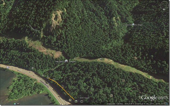
Still, looking at the map above, it seems like Harrison Falls may be marked a little too far upstream.  Standing on the west side of the ravine above, though, under the powerlines, one can hear Harrison Falls towards the freeway, but it sounds like there is another large waterfall upstream from it to the south, best heard from the south edge of the powerline clearing.


Above a waterfall?
Sure sounds like it, but it is tricky and dangerous getting much closer than this. Upstream from Harrison Falls so I think this is a different one.  There is a third further to the south, but I suspect this is the big one on Lindsey Creek, it's quite a drop between the valley on the right and the ravine on the left.
Columbia River Gorge National Scenic Area. Oregon. November 1, 2013.

Not quite sure what is down there, and at first I thought it was the waterfall Scott Cook calls Lindsey Creek Falls in his book Pokin’ Round The Gorge, but reading the directions to that waterfall a little more closely, and then tracing them out on Google Earth, this is starting to sound more like the one marked on the map above and one I’ve glimpsed from the Lindsey Creek Road, which is marked in blue on the map below.

Jess - Lindesy Creek Road
Map by Paul Jess. 
https://www.flickr.com/photos/21209133@N06/5851360195/in/set-72157627002746570

"Upper" Lindesy Creek Falls (2013)
"Upper" Lindsey Creek Falls from the old Lindsey Creek road grade (2013)
The perspective in the photo above is a bit strange, since it looks like it was taken from the west side of the ravine, but due to the meandering nature of the creek and the high power zoom, this is just an illusion, this was taken from the east side of the ravine.
Columbia River Gorge National Scenic Area. Oregon. November 1, 2013.
Copyright © 2014 A. F. Litt , All Rights Reserved

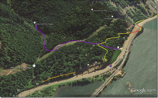
Cook’s directions to the falls start at the same location as Curious Gorge Hike #32: Summit Falls/Historic Highway Loop (pg. 76, 2012 edition), but then following the BPA access road’s east fork towards Lindsey Creek.

Follow the double track to the last tower, cut left around it then swing to the right, under the lines and over the sticks into the forest.  Pick your way on the old roadbed for a minute until you see a rough trail climbing down to the left.  Follow this down then angle upstream and bushwhack over to the creek … and take note of where you are so you can find it on the way back!  Now you begin to splash, bob, weave and hop for 8-9 minutes to the falls.

           Scott Cook.  Pokin’ Round the Gorge.  Hood River, OR: Scott Cook. 2008. 81.

Roughly recreating his directions in Google Earth leads to a map that looks like this, though in November 2013, few traces of the roads Cook describes were visible.  The route below is speculative, so please use caution if attempting to follow it, and it is based on a combination of Cook’s directions and my own experience in the area.
Upper Lindesy Creek Map

His photo of the falls themselves graces the cover of the book.  There are more inside, but due to the nature of that book, and this site, this is the only one I’m comfortable posting!

Lindsey Creek Falls

So, is there a hidden “Middle” Lindsey Creek Falls?  There could be.  Cook’s directions to the upper falls seems to bypass the area where the sound of a waterfall is coming from.  Also, zooming in a bit on Google Earth, there sure seems to be at least one waterfall down there that looks at least as large as Harrison Falls. 

Middle Lindsey Creek Falls
Click to enlarge…

One of these days I’ll pick my way down into that ravine and find out, unfortunately, the last time I was there I was by myself, it was getting late, and nobody really knew where I was if something went wrong, so I was playing it really safe and taking no risks.  But I think this summer, tramping up and down the creek on a hot summer day may be a fun adventure! 

I’ll update with what I find!

Update – Like 15 minutes later…

I need to remember to hit Google before I hit send…

A good thread (with great pictures) on Lindsey Creek.  Probably not a big “middle” falls in there, just lots of whitewater essentially making the whole stretch one big falls.  But there are more falls upstream from Lindsey Creek Falls.

Lindsey Creek 8 23 2011: http://www.portlandhikers.org/forum/viewtopic.php?f=10&t=9227

More on the Lindsey Creek Falls:

http://www.portlandhikers.org/forum/viewtopic.php?f=10&t=18797

Related Posts

Tuesday, October 15, 2013

First Nations of the Gorge: Columbia Gorge Discovery Center Photo Archive

Since I will be taking part in a photo shoot with a Native American theme in the Gorge this weekend, I thought I'd share some historical photos...

Columbia Gorge Discovery Center Photo Archive


Catalog Num: 2002.13.28
Condition: Good
Date: 
Location: Celilo Falls
Title: 
Content: Indian fishing with dipnet in eddy of the Columbia river.
Other Notes: Used as cover photo for 1987 WCHS calendar. Remarks on back. Duplicate measures same size.
Photographer: 
Copyright: Published


Many more photos after the break...

Friday, September 20, 2013

Recreating the Historic Columbia River Highway: Lancaster's Lodge and Retirement Cabin at Tanner Creek

This is the sort of post that will soon live on a new site dedicated to the Columbia River Highway Project...

Several of us were discussing Lancaster's retirement during the weekend of the Yeon to Moffett Creek HCRH Trail Dedication...  Apparently, I was combining these two stories.  I was saying that Lancaster retired on Bell's property, but it seems that these were two different locations.

"Samuel Lancaster built a private 72-acre campground at Bonneville that overlooked Bradford Island and the lower Cascade rapids. He constructed a log dining hall and tent 'cabins' at camping areas. Lancaster used facilities he had observed in Switzerland as a model for his development. The log structure burned in the late 1920s and was not replaced. In 1928, Sam Hill built a 22-room house on a 35-acre estate at Bonneville for his 'friend' Mona Bell. Because the property was required for the construction of Bonneville Dam, the government purchased the estate in 1934." - Clarence E. Mershon, The Columbia River Highway: From the Sea to the Wheat Fields of Eastern Oregon

"...while across the road Lancaster established a campground and recreational facility, Camp Get-A-Way." - Clarence E. Mershon, East of the Sandy: The Columbia River Highway

"In the 20s, Sam Hill built a large home on top of the large rock formation north of I-84, east of exit 40. The house was razed in the late 50s." - Clarence E. Mershon, East of the Sandy: The Columbia River Highway


Additional photos from Curious Gorge:

The long-gone Mona Bell mansion built by Sam Hill for his mistress Mona Bell: 

http://www.panoramio.com/photo/52098770

Mona Bell's one-time mansion atop Bonneville Rock:

http://www.panoramio.com/photo/74053683

Remnant foundation of Mona Bell Hill's mansion:

http://www.panoramio.com/photo/74053689


Bell's mansion was on the hill on the east end of the screenshot above, between I-84 and the railroad tracks.  The relocation of the rail line to its current route when its former path was flooded by the dam apparently blasted away a large chunk of Mona's hill, and the construction of I-84 apparently took out another large chunk of it, leaving only a sliver of the land that once held her mansion and, consequently, only a small sliver remains of Bonneville State Park.

Recreating the Historic Columbia River Highway:
 http://www.panoramio.com/group/265904
https://www.facebook.com/RecreatingTheHistoricColumbiaRiverHighway