Showing posts with label flowers. Show all posts

Tuesday, June 13, 2017

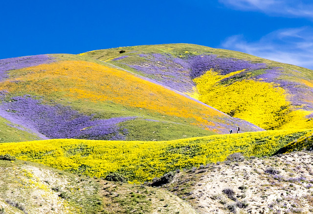
Carrizo Plain National Monument: Super Bloom

Carrizo Plain National Monument
Photo by Bob Wick, BLM Wilderness Specialist and Photographer
Carrizo Plain National Monument.  California.  April 2, 2017.
https://flic.kr/p/TjXSpT

The best laid plans...  I was hoping to visit this monument last year as a part of my December trip south, but life did not co-operate.  No pictures of my own.
Carrizo Plain National Monument
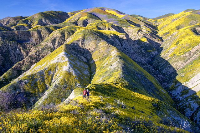
Photo by Bob Wick, BLM Wilderness Specialist and Photographer
Carrizo Plain National Monument.  California.  April 1, 2017.
https://flic.kr/p/TjXTgx

This southern California monument, proclaimed by President Clinton on January 17, 2001, is one of the nearly 30 monuments currently at-risk of elimination by the Trump Administration.
Carrizo Plain National Monument
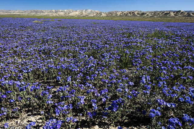
Photo by Bob Wick, BLM Wilderness Specialist and Photographer
Carrizo Plain National Monument.  California.  March 26, 2016.

Three hundred years ago, California’s Central Valley was vast grassland where antelope and elk grazed and wildflowers swept the spring landscape. Today, amid urban and agriculture development, a remnant remains in the Carrizo Plain National Monument.
Carrizo Plain National Monument is one of the best kept secrets in California.  Only a few hours from Los Angeles, the Carrizo Plain offers visitors a rare chance to be alone with nature.  Some visitors say you can "hear the silence."  The plain is home to diverse communities of wildlife and plant species including several listed as threatened or endangered and is an area culturally important to Native Americans.     This remote monument, traversed by the San Andreas Fault which has carved valleys, created and moved mountains, and yet up close, is seen in subtle alignment of ridges, ravines and normally dry ponds.  Prominent features on the monument include the white alkali flats of Soda Lake, Painted Rock, vast open grasslands, and a broad plain rimmed by mountains.   When conditions are right, numerous wildflowers can carpet the valley floor; although short lived it can be breathtaking.
Soda Lake, normally a dry lake bed, is one of the dominant geographic features of the Carrizo Plain.  It is the largest remaining natural alkali wetland in southern California and the only closed basin within the coastal mountains.  As its name suggests, Soda Lake concentrates salts as water evaporates, leaving white deposits of sulfates and carbonates that look like baking soda.
https://www.blm.gov/nlcs_web/sites/ca/st/en/prog/nlcs/Carrizo_Plain_NM.html
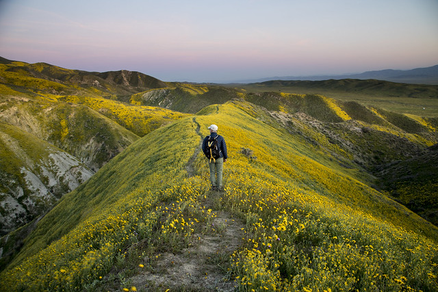
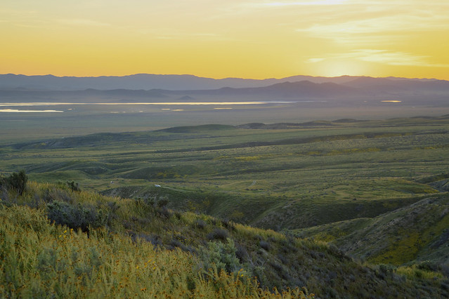
Super Bloom 2017 at Carrizo Plain National Monument
Photo by Bob Wick, BLM Wilderness Specialist and Photographer
Carrizo Plain National Monument.  California.  April 1, 2017.
https://flic.kr/p/TZMfNx


 "Healthy" rains this spring led to an "epic" wild flower bloom in southern California this spring, the Los Angeles Times reported in early April.

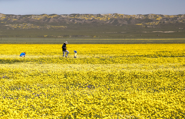
The super bloom has migrated north to California's Central Valley and the show is simply indescribable at the Carrizo Plain National Monument. The Valley floor has endless expanses of yellows and purples from coreopsis, tidy tips and phacelia, with smaller patches of dozens of other species. Not to be outdone, the Temblor Range is painted with swaths of orange, yellow and purple like something out of a storybook. I have never seen such a spectacular array of blooms. Ever.
Bob Wick: https://flic.kr/p/TjXSpT
Super Bloom 2017 at Carrizo Plain National Monument
Photo by Bob Wick, BLM Wilderness Specialist and Photographer
Carrizo Plain National Monument.  California.  April 1, 2017.
https://flic.kr/p/TWcVA9

Check out the links below for some awesome photos from the 2017 "Super Bloom."

Carrizo Plain National Monument

Preamble to the Presidential Proclamation Establishing Carrizo Plain National Monument:

Full of natural splendor and rich in human history, the majestic
grasslands and stark ridges in the Carrizo Plain National Monument
contain exceptional objects of scientific and historic interest. Since
the mid-1800s, large portions of the grasslands that once spanned the
entire four hundred mile expanse of California's nearby San Joaquin
Valley and other valleys in the vicinity have been eliminated by
extensive land conversion to agricultural, industrial, and urban land
uses. The Carrizo Plain National Monument, which is dramatically
bisected by the San Andreas Fault zone, is the largest undeveloped
remnant of this ecosystem, providing crucial habitat for the long-term
conservation of the many endemic plant and animal species that still
inhabit the area.

The monument offers a refuge for endangered, threatened, and rare
animal species such as the San Joaquin kit fox, the California condor,
the blunt-nosed leopard lizard, the giant kangaroo rat, the San Joaquin
antelope squirrel, the longhorn fairy shrimp, and the vernal pool fairy
shrimp. It supports important populations of pronghorn antelope and tule
elk. The area is also home to many rare and sensitive plant species,
including the California jewelflower, the Hoover's woolly-star, the SanJoaquin
woolly-threads, the pale-yellow layia, the forked fiddleneck,
the Carrizo peppergrass, the Lost Hills saltbush, the Temblor buckwheat,
the recurved larkspur, and the Munz's tidy-tips. Despite past human use,
the size, isolation, and relatively undeveloped nature of the area make
it ideal for long-term conservation of the dwindling flora and fauna
characteristic of the San Joaquin Valley region.

The Carrizo Plain National Monument also encompasses Soda Lake, the
largest remaining natural alkali wetland in southern California and the
only closed basin within the coastal mountains. As its name suggests,
Soda Lake concentrates salts as water is evaporated away, leaving white
deposits of sulfates and carbonates. Despite this harsh environment,
small plant and animal species are well adapted to the setting, which is
also important to migratory birds. During the winter months the lake
fills with water and teems with thousands of beautiful lesser sandhill
cranes, long-billed curlews, and mountain plovers.

The Carrizo Plain National Monument owes its existence to the
geologic processes that occur along the San Andreas Fault, where two of
the Earth's five great tectonic plates slide past one another, parallel
to the axis of the Plain. Shifting along the fault created the Plain by
rumpling the rocks to the northeast into the Temblor Range and isolating
the Plain from the rest of the San Joaquin Valley. The area is worldfamous
for its spectacular exposures of fault-generated landforms.

Stream valleys emerge from the adjacent mountains, only to take dramatic
right-angle turns where they intersect the fault. Ponds and sags form
where the ground is extended and subsides between branches of the fault. 
Benches form where the fault offsets valley walls. Many dramatic
landscape features are products of the interplay between very rapid
fault movement and slower erosion. The dry climate of the area produces
low erosion rates, thereby preserving the spectacular effects of fault
slip, folding, and warping. On the Plain, these fault-related events
happen intermittently, but with great force. In 1857, the strongest
earthquake in California's recorded history ripped through the San
Andreas Fault, wrenching the western side of the Carrizo Plain National
Monument thirty-one feet northward.

The area is also distinguished for its significant fossil
assemblages. The Caliente Formation, exposed on the southeast side of
the Caliente Range, is host to abundant and diverse terrestrial fossil
mammal remains of the Miocene Epoch (from 13 million to 25 million years
ago). Fossils of five North American provincial mammalian ages
(Arikareean, Hemingfordian, Barstovian, Clarendonian, Hemphillian) are
represented in sedimentary rocks in that formation. These terrestrial
fossil remains are interlaced with marine sedimentary rocks bearing
fossils of mollusks, pectens, turitellas, and oysters.

In addition to its geologic and biological wealth, the area is rich
in human history. Archaeologists theorize that humans have occupied the
Carrizo Plain National Monument area since the Paleo-Indian Period
(circa 11,000 to 9,000 B.C.). Bedrock mortar milling features, village
middens, and elaborate pictographs are the primary manifestations of
prehistoric occupation. Some of these, such as the Painted Rock and
Sulphur Springs rock art sites, are recognized as world class. European
expeditions through the area date back to the late 1700s, with
settlement beginning in the 1850s. Livestock ranching, farming, and
mining activities in the last century and a half are evidenced by
numerous artifacts and historic ranch properties within the area.


BLM: Carrizo Plain National Monument Map (as of June 2017) - PDF


Links


BLM:


Carrizo Plain NM:

National Monument Map:

flikr:  BLM - Carrizo Plain National Monument Wildflowers


Presidential Proclamation Establishing Carrizo Plain National Monument


Wikipedia:


Los Angeles Times:

What you need to know about the 'super bloom' at Carrizo Plain National Monument (April 7, 2017)

Your chance to see Southern California’s epic wildflower bloom is running out. Here’s where to go (April 8, 2017)

National Monuments in Danger:


To comment on the monument review process (due July 10, 2017):

Friday, June 09, 2017

Bears Ears National Monument: Butler Wash

Butler Wash Ruins
Bears Ears National Monument. Utah. May 12, 2016.
Copyright © 2017 A. F. Litt, All Rights Reserved
www.aflitt.com/bearsearsnm


Interior Secretary Ryan Zinke Reviews Bears Ears National Monument

A Saturday deadline is approaching for Interior Secretary Ryan Zinke to recommend whether the controversial new Bears Ears National Monument in Utah should be abolished or shrunk. It's the first of a larger review of national monuments stemming from an executive order by President Trump last month.
http://www.npr.org/2017/06/09/532289014/interior-secretary-ryan-zinke-reviews-bears-ears-national-monument

So the monument wasn't a monument when I was last there a little over a year ago, and the monument may not be a monument the next time I visit.

This is a nice ruin with a very developed, mile long access trail just off of SR 95, just east of Comb Ridge.

One of the arguments against this monument is that it is "too big," and yes, it is huge.  And sites like this are already well managed and protected by the BLM.  However, this is just one of thousands of sites like this within the monument, and the vast majority are pristine...  Check out some of the videos through the link below to see what I mean; they are still filled with pot shards, corncobs, etc.  

It's these other sorts of sites that I worry about.  It's places like the ancient road that runs a little to the north from here (which I'll write about later), and other mysteries left by the Ancestral Puebloans that remain to be discovered and understood.

While most of the monument will remain under BLM management even if the current status is revoked, there is still a concern that the area will be flooded with new oil and gas leases...  It would be a shame if these were granted near, or even on, sites that may hold tremendous historical and cultural value that we don't even recognize yet.

Of course, there are other land uses, too, permitted on BLM land that would be prohibited in a monument that can also be very destructive to sensitive archeological sites and natural areas, but I am, personally,  mostly concerned about the leasing or selling outright of the land to commercial industries.

Ultimately, I see any oil and gas reserves left under these monuments and parks, in the West and in Alaska, to really be just that, reserves.  At this point it is nothing but greed that drives this sort of development.  However, if we ever truly did need to tap these resources due to a true, long term crisis, they will still be there, and, to me, that is the proper time to have that debate.

As for the rest of the land use issues, it is critical that the BLM works with the locals to make sure everyone's needs are met, regardless of the land's status, monument or not...

For my thoughts on the non-National Park Service monuments in general, I wrote a lot about that last fall in my first post on Grand Staircase-Escalante.

Yucca on Butler Wash Trail 
Flowers on Butler Wash Trail


BLM: Bears Ears National Monument Map (as of June 2017) - PDF


Links


To comment on the monument review process (due July 10, 2017):

Rubble:

Bears Ears National Monument: A Quick Tour of a Monument at Risk
http://rubble.blogspot.com/2017/06/bears-ears-nm-quick-tour.html

Bears Ears National Monument: Video and Links Collection

BLM: 


Wikipedia: 


Department of the Interior:

Department of the Interior Press release on Bears Ears Monument Review (June 13, 2017)
Utah residents to Ryan Zinke: Hands off Bears Ears! (New analysis of submitted comments finds overwhelming in-state support for national monuments)
https://medium.com/westwise/utah-residents-to-ryan-zinke-hands-off-bears-ears-e2684046a3b4

Salt Lake Tribune: 

Sources: Zinke to urge diminishing size of Bears Ears National Monument (June 12, 2017)
http://www.sltrib.com/news/5393496-155/sources-zinke-to-urge-diminishing-size

Op-ed: State politicians may not support our newest monument but real Utahns do (June 9, 2017)
http://www.sltrib.com/opinion/5359199-155/op-ed-state-politicians-may-not-support

Theodore Roosevelt IV: Bear Ears: A story of what passes and what endures

Jewell defends Bears Ears monument process

BLM yanks oil and gas leases proposed near Zion after complaints from residents

Deseret News: 

BLM, Forest Service plotting next steps for Bears Ears

San Juan Record:

Secretary Zinke recommends reduced size of Bears Ears National Monument (June 13, 2017)

Sec. Zinke to make Bears Ears recommendation (June 6, 2017)

Bears Ears National Monument designation disastrous for Utah grassroots Navajos (April 12, 2016)
http://sjrnews.com/view/full_story/27152945/article-Bears-Ears-National-Monument-designation-disastrous-for-Utah-grassroots-Navajos

NPR:

Interior Secretary Ryan Zinke Reviews Bears Ears National Monument (June 9, 2017)
http://www.npr.org/2017/06/09/532289014/interior-secretary-ryan-zinke-reviews-bears-ears-national-monument

With National Monuments Under Review, Bears Ears Is Focus Of Fierce Debate (May 5, 2017)
http://www.npr.org/2017/05/05/526860725/with-national-monuments-under-review-bears-ears-is-focus-of-fierce-debate

Utah’s Bears Ears monument is a rock star for night skies – and mineral resources

The Wilderness Society:

Photo gallery: Utah's Bears Ears region is a natural & cultural treasure

Unprecedented outpouring of support for Bears Ears shown during official comment period


National Monuments in Danger:

CLICK HERE for posts about the monuments being "reviewed" by the Trump Administration


To comment on the monument review process (due July 10, 2017):

Thursday, July 21, 2016

Agate Fossil Beds National Monument

Bones At Agate Fossil Beds National Monument
Agate Fossil Beds National Monument.  Nebraska.  August 10, 2014
http://www.aflitt.com/agatefossilbedsnm
Copyright © 2016 A. F. Litt, All Rights Reserved

Photo of the Day by A. F. Litt: Day of Several Photos - July 21, 2016


Day three of my focus on stills and blog posts this week, then back to video editing tomorrow.  Rather than getting bogged down for hours on longer posts about individual parks, today I plan on focusing more on single photos and trying to post as much as I can...

Of course, that being said, I am starting the day by breaking this "rule" and throwing up everything I have for Agate Fossil Beds, a small National Monument in western Nebraska, far away from anything and everything...  However, since it is a small park that mostly focuses on the Visitor Center / Museum, I only have a handful of shots to begin with, so I'll close this park out for now.

This was a very cool spot.  While the landscape is not as spectacular as what is found at John Day Fossil Beds National Monument here in Oregon, which could probably qualify for National Monument status even without the fossils, the mixed grass prairie is very pleasant.  But the attraction here is really the bones.

There are no dinosaurs here.  This is a Cenozoic Era (65 million years BP to present) bed featuring large mammals from the Miocene Epoch (23 million years BP to 5 million years BP).  The fossils date to around 19 - 20 million years BP when two small, shallow ponds attracted a large number of animals during a long drought.  Many of these critters would die there.  These ponds have become, through the magic of various geologic processes, the Carnegie and University Hill fossil beds.

Also preserved within the monument are a number of "Devil's Corkscrews" - Daemonelix. These are the dens of the Palaeocastor, an extinct genus of beaver.  The origin of these strange formations was a mystery for quite some time and were first thought to be the fossils of some sort of vegetation or sponge.  Finally, the fossilized remains of  of a beaver were found inside of one of the structures, solving the mystery.

"Devil's corkscrews," Miocene-age burrows of Palaeocastor, discovered in the late 19th century
Circa late 19th or early 20th century.
Posted to flikr / Wikimedia Commons by James St. John; CC Attribution 2.0 Generic
https://commons.wikimedia.org/wiki/File%3ADaemonelix_burrows%2C_Agate_Fossil_Beds.jpg

As I've written so much over the last few days, we just didn't have enough time... Unfortunately, we did not have the time to hike out the Daemonelix Trail to see these formations or to hike up the Fossil Hills Trail to see the fossil beds.

The monument was once part of James H. Cook's Agate Springs Ranch, which still exists across Highway 29.  The fossils were first discovered in the 1890s and Cook was soon hosting teams of researchers from many institutions, including the Carnegie Museum, Yale University, and the American Museum of Natural History.

Cook also maintained great relationships with the local Indians and had a lifelong friendship with Chief Red Cloud of the Oglala Lakota.  Over the years he collected many Native American gifts and artifacts, which have become the Cook Collection of Indian Artifacts, on display in the monument's Visitor Center.

According to Wikipedia, "The national monument was authorized on June 5, 1965, but was not established until June 14, 1997. The Harold J. Cook Homestead (Bone Cabin Complex) was listed on the National Register of Historic Places in 1977."

The bone cabin was the Cooks' original residence and used, after 1914, a   It has been restored to its 1910 condition.

The Bone Cabin, used during twenty-five years of fossil excavations at the Agate Fossil Beds
Harold J. Cook Homestead Cabin, more commonly known as Bone Cabin, located on south side of Niobrara River at Agate Fossil Beds National Monument.
Photo by Ammodramus, CC0 ; Taken on August 16, 2012
https://commons.wikimedia.org/wiki/File%3ABone_Cabin%2C_Agate_Fossil_Beds_NM_3.JPG

Agate Fossil Beds is one of a series of "sister" national parks and monuments that focus on Cenozoic Era fossils, or have large beds of Cenozoic fossils.  These sister parks are Hagerman Fossil Beds NM in Idaho, Fossil Butte NM in Wyoming, Badlands NP in South Dakota, Florissant Fossil Beds NM in Colorado, and John Day Fossil Beds NM.  In fact, one of the rangers was excited to hear that were were from Oregon because of the John Day Fossil Beds monument and asked if we had spent any time there.  Of course we have!

Flowers at the Daemonelix Trailhead
Agate Fossil Beds National Monument.  Nebraska.  August 10, 2014
http://www.aflitt.com/agatefossilbedsnm
Copyright © 2016 A. F. Litt, All Rights Reserved


The Bone Cabin (Cook Homestead) At Agate Fossil Beds
Agate Fossil Beds National Monument.  Nebraska.  August 10, 2014
http://www.aflitt.com/agatefossilbedsnm
Copyright © 2016 A. F. Litt, All Rights Reserved

Where the Fossils Hide, University and Carnegie Hills...
Agate Fossil Beds National Monument.  Nebraska.  August 10, 2014
http://www.aflitt.com/agatefossilbedsnm
Copyright © 2016 A. F. Litt, All Rights Reserved

Large Mammal Skeletons On Display
Agate Fossil Beds National Monument.  Nebraska.  August 10, 2014
http://www.aflitt.com/agatefossilbedsnm
Copyright © 2016 A. F. Litt, All Rights Reserved

Monday, October 12, 2015

Flower on Abandoned Columbia River Highway

A. F. Litt: Eagle Creek to Cascade Locks &emdash; Flower on Abandoned Columbia River Highway (2014)

Flower on Abandoned Columbia River Highway (2014)
Abandoned HCRH Fragment. Near Eagle Creek. Oregon. April 20, 2014.
Copyright © 2015 A. F. Litt, All Rights Reserved


Photo of the Day by A. F. Litt: October 12, 2015

Just something blooming along a permanently abandoned fragment of the HCRH...

#HCRH http://www.RecreatingTheHCRH.org
http://www.aflitt.com

Thursday, October 01, 2015

Resuming the Photo of the Day

A. F. Litt: Hood River Bridge & Loops &emdash; Flower Near Old Hood River Bridge (2013)

Flower Near Old Hood River Bridge (2013)
Hood River, Oregon. May 6, 2013
#HCRH, #HistoricColumbiaRiverHighway http://www.recreatingTheHCRH.org
Copyright © 2015 A. F. Litt , All Rights Reserved


Photo of the Day by A. F. Litt: October 1, 2015 

I am going to try to get this going again.  It may be a lot (A LOT) of photos from the Historic Columbia River Highway to start.

What was killing me the last time out was trying to tack on a decent blog post for each photo.  I would like to do that from time to time, but to make this work, it can't be more than a few words most days.

So, today, I'm starting with a flower...

Friday, January 02, 2015

Badlands Bumble Bee

A. F. Litt: Badlands National Park &emdash; Bumble Bee on Sage Creek Rim Road

Bumble Bee on Sage Creek Rim Road
Sage Creek Basin Overlook. Badlands National Park. South Dakota. August 9, 2014
Copyright © 2015 A. F. Litt, All Rights Reserved

Photo of the Day by A. F. Litt: January 2, 2015

Heading back to the photos from our August wanderings for a bit.  Again, don’t have a ton of time today, so not a lot of writing.  Spent this day wandering through the old Minutemen NHS sites and Badlands National Park.  Oh, and Wall Drug, of course…

This was near the end of trip.  From here we turned south to Nebraska before jamming home, in just a couple days, mostly following the old Oregon Trail route.  Plenty more pictures to follow, though.  It was a busy few days.

There were a lot of nasty biting flies along the Rim this day.  This was about the only bug I was happy to see along this drive and at these viewpoints.

On 500px: https://500px.com/photo/94415753/bumble-bee-on-sage-creek-rim-road-by-a-f-litt

On www.aflitt.com: http://www.aflitt.com/p306041278/eebbc583

Related Posts

Thursday, May 31, 2012