Showing posts with label Wyoming. Show all posts

Wednesday, August 02, 2017

"Delisted" by the NPS: Flaming Gorge National Recreation Area

Firehole Canyon Formations
Firehole Canyon Campground. Flaming Gorge National Recreation Area. Wyoming.  August 12, 2014
Copyright © 2017 A. F. Litt, All Rights Reserved
 www.aflitt.com/FlamingGorgeNRA


National Monuments in Danger

https://sites.google.com/view/nationalmonumentsindanger/home


To comment on the marine monument and sanctuary review process 
(Due August 14, 2017):
https://www.regulations.gov/document?D=NOAA-NOS-2017-0066-0001


For the last couple of days, I've been doing a lot of research on the 11 National Monuments that have been abolished since the creation of the first monument, Devils Tower, in 1906. With the review process moving along on the 27 monuments currently in danger of reduction or elimination, I figured that it would be nice to have some historical context to put all of this in.

While working on that research, I discovered some great information on 23 or 24 units, depending on the source, of the National Park Service (NPS) system that were "delisted" from 1916 through 1991. For the sake of providing additional historical context to the current debates over the 27 monuments, I will be sharing some material about these other sites over the next couple of months.

As I wrote in a post a few days ago, this is all a part of the evolution of this project. While the primary focus, for now, will remain on the 27 monuments under review, I foresee this project expanding over time to cover many different issues with our national parks, monuments, and other protected areas. Already, today, I've expanded the project website quite a bit, and more changes are on their way.

So today's post is not on one of the 27 monuments, but on a National Recreation Area.  It is a former NPS site that was transferred by Congress to the U. S. Forest Service (USFS) in 1968.

Consistent with a departmental policy of reducing joint administrations, the USNPS withdrew in 1968, and the USFS administers the entire area today...   The former USNPS portion, north of the Unita Mountains, is characterized by rolling sagebrush rangelands sloping gently west from the shore of the reservoir, and by more abrupt relief to the east. The picturesque Firehole Canyon is part of this area.  Campground and boat launch facilities were developed by the USNPS at several sites, including Lucerne Valley on the western shore and Antelope Flat on the eastern.  

-- Alen K. Hogenauer 

The dam and reservoir system is managed by the Department of Reclamation, and an administrative agreement was signed on July 22, 1963 with the NPS regarding the recreational management of the lake. In this way, an article from National Parks Traveler explains, "without a Congressional mandate – there was no specific act of Congress -- Flaming Gorge National Recreation Area became a unit of the National Park System."

However, at the time, the NPS was actually trying to become less involved with the management of reservoirs, and saw this as little more than a brief "custodial arrangement not destined to last any longer than it had to." The NRA was only a part of the National Park System for five years because of this, and on October 1, 1968, Congress passed the responsibility of the NRA to the USFS' Ashley National Forest.

Other reservoirs the NPS unburdened themselves of include portions of the Shasta Lake National Recreation Area in 1948, the Shadow Mountain National Recreation Area in 1979, both of which passed to the USFS, the Lake Texoma National Recreation Area which passed to the U. S. Army Corps. of Engineers in 1949, and the Millerton Lake National Recreation Area which passed to the State of California in 1957.

In the article's comments, there is a discussion among the readers about the Park Service's management of reservoirs, and almost everyone seems to agree with the Service's approach to this here.

One reader suggested that the deciding factor should be whether or not the park offered more than just "water-based recreation," suggesting that Recreation Areas like Glen Canyon, Lake Mead, and Ross Lake (part of the North Cascades National Park Complex) all seem like good fits for the NPS because "the surrounding holdings are extensive and worthy natural and cultural resources," while Recreation Areas like Lake Roosevelt, Lake Meredith, Amistad, and Curecanti may be better run by the USFS or the Army Corps of Engineers' "excellent public recreation operation."

Another reader pointed out, "The NPS apparently very much wants to keep Curecanti NRA, and currently has a plan out for public comment that would expand Curecanti and calls on Congress to officially designate the NPS manager of the public land surrounding Curecanti's three reservoirs."

Personally, I'd hate to see Lake Roosevelt go away.  That was my local park growing up and where my love of the national parks first got started.

Of course, this is all just idle musings... There is no movement I know of looking at delisting any of the National Recreation Areas.

Ultimately, though, Flaming Gorge remains a National Recreation area, it's status has not changed, just the management.  It was not abolished, it just changed hands.  Unfortunately, with the 27 monuments, being a part of the National Park Service system is really only a factor for Katahdin Woods, the core of Craters of the Moon, and the Parashant section of Grand Canyon-Parashant National Monument.  The rest of the monuments are not facing delisting by the Park Service, they are looking at the loss of National Monument status completely.

But it is interesting to note, all of the 11 National Monuments that were abolished had their status removed by Congress.  With Flaming Gorge, even just the change in management required Congressional action.  This suggests that the President does not have to power to unilaterally change our monuments, though I suspect that he will try.

If he does, it may be a long slog through the courts before any of these issues are resolved.


Flaming Gorge National Recreation Area


Wyoming / Utah
Established: October 22, 1963

324 Sq. Miles
USFS / NPS (Northern Portion)
NPS Withdrawal: October 1, 1968 by Congress


North Chimney Rock In Firehole Canyon (July 19, 2016)
http://rubble.blogspot.com/2016/07/north-chimney-rock-in-firehole-canyon.html

National Monuments in Danger
https://sites.google.com/view/nationalmonumentsindanger/abolished-monuments/delisted-nps-sites


To comment on the marine monument and sanctuary review process 
(Due August 14, 2017):
https://www.regulations.gov/document?D=NOAA-NOS-2017-0066-0001


Video (By Others...)


Links


National Parks Traveler

Pruning the Parks: Flaming Gorge National Recreation Area Was a National Park for Just Five Years


USFS
http://www.fs.usda.gov/detail/ashley/specialplaces/?cid=stelprdb5212203


Wikipedia


Flaming Gorge NRA: https://en.wikipedia.org/wiki/Flaming_Gorge_National_Recreation_Area


Flaming Gorge Reservoir: https://en.wikipedia.org/wiki/Flaming_Gorge_Reservoir


The George Wright Forum

Gone, But Not Forgotten: The Delisted Units of the U. S. National Park system (1991)


Green River, Flaming Gorge and Red Canyon: Historic 3D Photographs of Powell Survey 2nd Expedition 1871-2 (USGS)
https://3dparks.wr.usgs.gov/3Dcanyons/html/flaminggorge.htm


NPS

About "Abolished" National Mouments
https://www.nps.gov/archeology/sites/antiquities/abolished.htm


Utah.com
https://utah.com/flaming-gorge


Wednesday, July 20, 2016

Grand Teton National Park: Afternoon At Jenny Lake

Afternoon At Jenny Lake
Grand Teton National Park.  Wyoming.  August 3, 2014.
www.aflitt.com/GrandTetonNP
Copyright © 2016 A. F. Litt, All Rights Reserved


Photo of the Day by A. F. Litt: Day of Several Photos - July 20, 2016


I was going to write about how afternoons are the worst at this park for photography, but I covered that in my first post on the Tetons.  It's late and I don't have much thought left in me today.  I wanted to get through many more photos than I did, at least, spread out around more parks, but I got everything I have out for Scotts Bluff National Monument and Chimney Rock National Historic Site.

My focus on National Parks this summer is largely inspired by this being the centennial of the National Park Service.  If I had the chance to plan ahead a bit more, my spring trip through the southwest might have turned into an across the country expedition to photograph as many parks as I could have...  Something like what the guys at 59in59.com are doing, though I'd include as many of the monuments, historic sites, recreation areas, etc. as I could, too.  In fact, while the big name national parks have their reputations for a reason, they also have the crowds and are well known already...  My heart is drawn more towards the lesser know places, the quieter spaces...  

Speaking of the 59 in 59 guys, we pretty much crossed paths in Utah this spring.  I even thought about trying to contact them to meet up, but that trip was more about isolation and self-exploration.  And even being on the road for nearly a month, I still barely had the time to visit everywhere I wanted to visit and to shoot and film everything I wanted to capture.

That trip, this spring, was a lot different than this family vacation in 2014.  That trip was dedicated to photography.  While I took a lot of photos on the 2014 trip, it was all on the fly as we tried to see as much as we could in the time we had available.  Because of that, at times, my photos were rushed, and the timing was not always optimal for the subjects I was wanting to shoot.  While I think a lot of the shots I've been posting this week were nice, many of the locations don't have the "wow" shots that I would like to have captured if I had a little more time, and a little more attention to pay to the work.  
However, visiting the sorts of spectacular places that we were visiting that summer, in many of the locations, the scenery provided as long as I didn't mess up the camera on my end.  I joke from time to time that, in places like Grand Teton National Park, photography is easy.  You can pretty much just randomly point the camera over your shoulder and walk away with a spectacular photograph.

In this shot, I am not absolutely sure which mountains are pictured...  Cascade Canyon is the main canyon on the right, and I believe that is Hanging Canyon in the center between the peaks...  So, I think this is all part of Mt. St. John, with Storm Point and Symmetry Spire being the two peaks, from left to right, rising between Cascade Canyon and Hanging Canyon.  However, I am not certain.  I should have taken a photo of a peak finder at the overlook, a practice I have since adopted.

According to Wikipedia, the lake is 423 feet deep, 1,191 acres, and "is named after a Shoshone Indian woman who married an Englishman, Richard 'Beaver Dick' Leigh," She and her six children died of Smallpox in 1876.

Links


NPS - Centennial
https://www.nps.gov/subjects/centennial/index.htm

NPS - Grand Teton National Park
https://www.nps.gov/grte/index.htm

Wikipedia

Tuesday, July 19, 2016

Fort Laramie National Historic Site

Clouds and Bakery Ruins
Fort Laramie National Historic Site.  Wyoming.  August 11, 2014.
Copyright © 2016 A. F. Litt, All Rights Reserved


Photo of the Day by A. F. Litt: Day of Several Photos - July 19, 2016


We were really only at Fort Laramie for a few minutes.  In fact, every photo I took there is in this post.  It was a quick stop on a long day's drive across Wyoming, generally following the route of the Oregon Trail from Chimney Rock in Nebraska on through to southwestern Wyoming.  But we were there, I took these photos, checked out the visitors' center, got our NPS Passports stamped, and rolled on our way.  We were the worst sort of auto tourists that day, but seeing a little was still better than seeing nothing.


Sagebrush and Hospital Ruins
Fort Laramie National Historic Site.  Wyoming.  August 11, 2014.
Copyright © 2016 A. F. Litt, All Rights Reserved
http://www.aflitt.com/fortlaramienhs  


The National Park Service brochure explains that the hospital, pictured above, was built in 1873 had 12 beds, a dispensary, a kitchen, a dining room, isolation rooms, a surgeon's office, and was the first lime-concreted building built at the fort.


"Old Bedlam" at Fort Laramie
Fort Laramie National Historic Site.  Wyoming.  August 11, 2014.
Copyright © 2016 A. F. Litt, All Rights Reserved

First established in 1834, the fort was obtained by the U.S. Army in 1849 to provide military support for the emigrant trails.  "Old Bedlam," the largest building in the above photo, was built at this time and is the oldest known building in the State of Wyoming.  According to the National Park Service brochure, "the right side is restored to bachelor offices' quarters in the 1850s; the left side to post headquarters in 1863-1864, when fort commander Lt. Col. William and his wife lived on the second floor."


1875 Fort Laramie Bridge (Platte River)


1876 Fort Laramie Bridge
Fort Laramie, Wyoming.  August 11, 2014. 
Copyright © 2016 A. F. Litt, All Rights Reserved

On the National Park Service map for Fort Laramie, a bridge very similar to this one is shown, though I do not think it is the same, since that one is over the Laramie River right at the old fort itself. However, the one shown on the map looks almost identical to this one.

While this location is not within the NHS, its history is so closely tied to that of the fort's, that I feel comfortable including these images in the park's gallery.


Fort Laramie Bridge and Plaques
1876 Fort Laramie Bridge.  Platte River.  Fort Laramie, Wyoming.  August 11, 2014. 
Copyright © 2016 A. F. Litt, All Rights Reserved
http://www.aflitt.com/fortlaramienhs 


1876 Fort Laramie Bridge
Fort Laramie, Wyoming.  August 11, 2014.
Copyright © 2016 A. F. Litt, All Rights Reserved
http://www.aflitt.com/fortlaramienhs  


Fort Laramie Bridge and Plaques 
1876 Fort Laramie Bridge.  Platte River.  Fort Laramie, Wyoming.  August 11, 2014.
Copyright © 2016 A. F. Litt, All Rights Reserved
http://www.aflitt.com/fortlaramienhs 


As I posted earlier, today I planned on burning through several photos, filling in some of the gaps in the National Parks section of the website (http://aflitt.com/NationalParks). I was not sure how many I could get through, but apparently the number of posts I can churn out in one afternoon is three!

Links


NPS - Fort Laramie National Historic Site

National Register of Historic Places Inventory—Nomination Form: Fort Laramie National Historic Site (Bad OCR or something going on here...)
http://focus.nps.gov/pdfhost/docs/NRHP/Text/66000755.pdf

Wikipedia
https://en.wikipedia.org/wiki/Fort_Laramie_National_Historic_Site

Bridgehunter: Fort Laramie Bridge 
https://bridgehunter.com/wy/goshen/fort-laramie/

North Chimney Rock In Firehole Canyon

North Chimney Rock In Firehole Canyon
Flaming Gorge National Recreation Area. Wyoming.  August 12, 2014
Copyright © 2016 A. F. Litt, All Rights Reserved
http://www.aflitt.com/flaminggorgenra/e73350960

Photo of the Day by A. F. Litt: Day of Several Photos - July 19, 2016


This was the last stop on a long, two week trip through many states back in 2014.  We rolled all the way across Wyoming the night before, traveling from Scotts Bluff, Nebraska along the old Oregon Trail route, past Independence Rock, and arriving at the Firehole Canyon Campground sometime around midnight or later.   

Originally the plan was to drop down US 191 to Vernal, Utah and Dinosaur National Monument, but first we headed back up to I-80 and civilization in search of breakfast, which we were all too burned out to cook ourselves that morning.  Once back out on the freeway, I realized that we were a day's drive (true, a very long day's drive, but do-able) away from home, and we decided to cut the trip a day short and to sleep in our own beds that night.

I still haven't made it back to Dinosaur...  I've been there a couple of times before, many, many years ago, when I was a kid.  On one of these Southwest trips over the next couple years, I hope to take my kids there to visit.

As for Flaming Gorge, this spot is pretty nice, as you can see.  It's about all of the area we got to explore, though, since the whole family was pretty tired and it was time to go home.

As I wrote in the last post, Today, I plan on burning through several photos, filling in some of the gaps in the National Parks section of the website (http://aflitt.com/NationalParks). I am not sure how many I will get through, but there should be several "photo of the day" posts today.

Firehole Canyon Panorama
Flaming Gorge National Recreation Area. Wyoming.  August 12, 2014  
Copyright © 2016 A. F. Litt, All Rights Reserved

Links


USFS
http://www.fs.usda.gov/detail/ashley/specialplaces/?cid=stelprdb5212203

Wikipedia
Flaming Gorge NRA: https://en.wikipedia.org/wiki/Flaming_Gorge_National_Recreation_Area
Flaming Gorge Reservoir: https://en.wikipedia.org/wiki/Flaming_Gorge_Reservoir

Utah.com
https://utah.com/flaming-gorge

Monday, November 16, 2015

A Rushed Evening Stop at Independence Rock

A. F. Litt: Wyoming &emdash; Independence Rock

Independence Rock
Independence Rock State Historic Site. Alcove, Wyoming. August 11, 2014
Copyright © 2015 A. F. Litt, All Rights Reserved

Photo of the Day by A. F. Litt: November 16, 2015

Busy and busy with a little sick thrown in, but I aim to get back on track with the POTD this week. Here is one from late in the day on one of the long travel days back in the summer of 2014. I was rushing here, against the daylight and against a van full of cranky family, so I didn't get the shots I'd loved to have captured here, but I got a few I like in spite of the challenges of time and place. It was a great time to be there, but time was just a luxury we did not have that evening.

Monday, November 10, 2014

Bear Lodge, Devils Tower NM

A. F. Litt: Devils Tower National Monument &emdash; Bear Lodge, Devils Tower NM  

Bear Lodge at Devils Tower NM
Devils Tower National Monument. Wyoming. August 6, 2014
Copyright © 2014 A. F. Litt, All Rights Reserved

Photo of the Day by A. F. Litt: November 10, 2014

The best laid plans…  Well, I hope to get back on track with the photo of the day after a month long hiatus.  Life got pretty busy there for a bit, as life tends to do, and I decided that rather than spending a month feeling guilty about not keeping up with the photo of the day I’d just put it on hold and re-launch the re-launch when I could realistically post on a regular basis. 

So, here goes…  I’m making plans-  I hope God doesn't laugh!

A month ago, I had a pretty decent post sketched out in my head for this photo, but a month of busy days later and those plans are faded.  On our trip, we visited many sites that are sacred to Native Americans, here and the Medicine Wheel probably being first and foremost.  I was going to post a weeks worth of photos on these sites in conjunction with Indigenous Peoples’ Day on October 13 (some may know that day by another term), but that week got very busy.

So I will pick up with this photo, but then move on.

As we followed our path across the west this summer, though, we did visit a lot of sacred places, and Bear Lodge and the Medicine Wheel were very powerful experiences for me.  It was my first visit to the Medicine Wheel, but my second to Devils Tower National Monument.  My first visit to the monument was many decades ago, and my excitement was centered around visiting the location that played such a major role in Spielberg’s Close Encounters of the Third Kind

On this visit, though, images of alien spacecraft floating around the tower had faded from my mind, and arriving at the monument on the same day that we visited the Medicine Wheel, I was in a more spiritual mindset. 

1-8063-Grizzly-Climbing-Devils-TowerThe painting here shows a scene from the etiological myth of the creation of this landform.  It’s real name is Bear Lodge…  Devils Tower is a western name from the pioneer days and is actually considered by many Indians to be rather offensive, because this is not a dark or evil place in their view.

And this is a spot where western ideas and indigenous ideas really clash…  The tower is considered to be one of the world’s great climbing spots, but climbing on a spiritual monument is rather insulting to those who feel that this is a sacred location.  Imagine peoples’ reaction if the Washington Monument was turned into a base jumping platform, or if St. Peter’s Basilica was turned into an EDM nightclub… 

So the National Park Service has a tough job here.  They’ve asked climbers to stay off the formation in June, the peak season for ceremonies to be held at the monument, and while this is merely a request, many, though not all, climbers honor this voluntary restriction.  They ask visitors to stay on the trails and not to use the site as a recreational playground, though this is difficult to enforce and even my own boys had trouble “remembering” to not leap parkour style between the boulders of the talus field at the formation’s base…

However, that lapse did lead to a very powerful discussion about faith and respect for everyone’s individual beliefs, which, while difficult at times, was pretty amazing.

To me, this should be a part of the power of these sites.  Even if we do not come from the spiritual tradition that led to these sites being recognized as sacred by the first peoples, we should appreciate this spiritual aspect when we visit these locations as much as we appreciate the sheer physical beauty of these spots.  If we can meditate and pray, or even have a discussion amongst ourselves about the junction of the physical and spiritual world that occurs in these locations, regardless of our individual beliefs, then even better!

I feel God’s presence very much in these sites.  While my faith does not assign any particular holiness to these specific locations, they are still some of the best works in our land of a God whose holiness infuses every place and every thing.  If other faiths recognize the sacredness inherent in these sites too, that can serve to remind us…  encourage us to remember… that there is a spirit in the land, regardless of how we define it, if we call it God, Allah, the Great Spirit, or anything else, even just simple Nature, and sites like this should be treated as sacred no matter what faith lays claim to this or that particular piece of real estate.

As for the name…  There is some noise about changing the name to Bear Lodge National Monument, but this is politically tricky, and there are some who feel that the history of the name Devils Tower should be respected as well.  While I side more with changing the name, I understand that a compromise may be in order, too.  So my suggestion would be to call the monolith Bear Lodge while keeping the name of the national monument as is. 

Hence my caption on this photo…  Bear Lodge at Devils Tower National Monument.

From the National Park Service:

On www.aflitt.com: http://www.aflitt.com/devilstowernm/e3e8c9321

On 500px: https://500px.com/photo/89335363/bear-lodge-devils-tower-nm-by-a-f-litt

Related Posts

(more..)

Monday, October 13, 2014

Medicine Wheel National Historic Site, Wyoming

Medicine Wheel
Bighorn National Forest.  Wyoming.  August 5, 2014
Copyright © 2014 A. F. Litt, All Rights Reserved
http://www.aflitt.com/medicinewheel-medicinemountainnhs

 
Photo of the Day by A. F. Litt:  October 13, 2014:

Not much time to write right now!  Just this for today…  Happy Indigenous Peoples’ Day!

Managed by the Bighorn National Forest (USFS). According to Wikipedia, "The site was declared a National Historic Landmark in 1970, and renamed as the Medicine Wheel/Medicine Mountain National Historic Landmark in 2011."

Links

Wikipedia:
http://en.wikipedia.org/wiki/Medicine_Wheel/Medicine_Mountain_National_Historic_Landmark

USFS:
http://www.fs.usda.gov/detail/bighorn/learning/history-culture/?cid=stelprdb5167397

Wyoming State Historic Preservation Office:
http://wyoshpo.state.wy.us/NationalRegister/Site.aspx?ID=60

Lovell Chronicle: Medicine Wheel landmark gets new boundary (July 7, 2011)
http://www.lovellchronicle.com/2011/07/medicine-wheel-landmark-gets-new-boundary


Related Posts

Thursday, October 09, 2014

Prairie Dog, Devil’s Tower NM

A. F. Litt: Devils Tower National Monument &emdash; Prairie Dog, Devils Tower National Monument 

Prairie Dog, Devils Tower National Monument
Prairie Dog Town.  Devils Tower NM.  Wyoming.  August 6, 2014
Copyright © 2014 A. F. Litt, All Rights Reserved

Photo of the Day by A. F. Litt:  October 9, 2014

Not much to say here, just a cute little guy whose been fed by some folks who can’t read the signs…  Behind me, loomed the tower, but this field was full of cuteness.  Busy day and not much to write about this shot, so I’ll move on…

On www.aflitt.com: http://www.aflitt.com/devilstowernm/e19c89d23

On 500px: https://500px.com/photo/85923645/prairie-dog-devils-tower-national-monument-by-a-f-litt

Related Posts

Wednesday, October 08, 2014

Devil’s Canyon Overlook, Bighorn Canyon NRA

A. F. Litt: Bighorn Canyon National Recreation Area &emdash; Devil's Canyon Overlook, Bighorn Canyon NRA

Devil's Canyon Overlook, Bighorn Canyon NRA
Bighorn Canyon National Recreation Area. Montana / Wyoming. August 5, 2014
Copyright © 2014 A. F. Litt, All Rights Reserved

Photo of the Day by A. F. Litt:  October 8, 2014

According to the National Park Service, this is the “Grandest Canyon in the Northern Rockies,” featuring:

A landscape of sheer cliffs towering 1,000 feet above a ribbon of blue water. World class fishing and a place where wild horses still run free. Bighorn Canyon is a place where imagination meets reality. Bighorn Canyon has unrivaled recreation possibilities.

http://www.nps.gov/bica/index.htm

So I’m back to the summer trip photos today…  Hopefully back on track with mostly daily posting, as well.

This was one of the few “new to me” location we visited on this trip, and it was a nice one.  We didn’t know much going in, just saw it on the map and decided to go, and it was a great side trip.  We saw wild horses, old homesteads, and, well, the canyon you see above.

I’d love to find a pre-1967 photo of the canyon before the completion of Yellowtail Dam.  The river was still high enough for boats, but there was a bit more whitewater down there.  There are some interesting stories about the boat trip into some ranches that lie in the heart of the NRA.

But I need to keep things short today.  More material to explore in later POTDs when I have a bit more time (hopefully).

On www.aflitt.com: http://bit.ly/1t32ZJj

On 500px: https://500px.com/photo/85806749/devil's-canyon-overlook-bighorn-canyon-nra-by-a-f-litt

Related Posts

Friday, September 12, 2014

Kayaks Visiting Fishing Cone Geyser

A. F. Litt: Yellowstone National Park &emdash; Kayaks Visiting Fishing Cone Geyser

Kayaks Visiting Fishing Cone Geyser
West Thumb Geyser Basin. Yellowstone Lake. Yellowstone National Park. August 4, 2014
Copyright © 2014 A. F. Litt, All Rights Reserved

Photo of the Day by A. F. Litt: September 12, 2014

A late post, a busy day…  This geyser, as seen in the photo below, is usually above water by this time of the year.  However, it’s been a wet one, so the water tables are high all over the west.

This is a pretty interesting location.  According to the National Park Service trail guide for the West Thumb Geyser Basin:

Mountain men told of a geyser along an alpine lake where one could catch a trout, swing the pole around, dip it into the boiling pool, and cook the fish without taking it off the line.

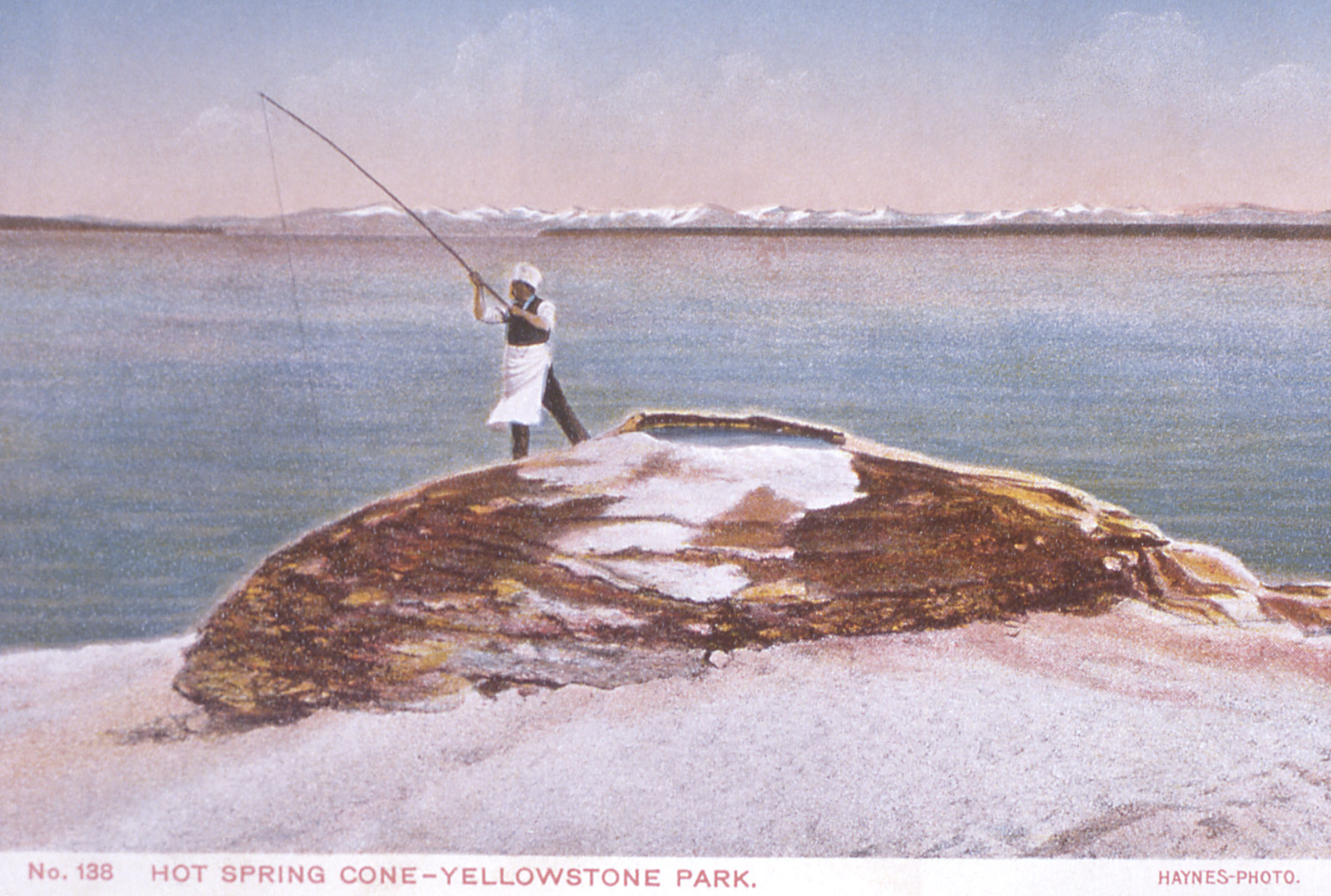
This cooking-on-the-hook feat at Fishing Cone became famous after being described by the 1870 Washburn Expedition.  Visitors often dressed in a cook’s hat and apron to have their pictures at the “Chowder Pot” or the “Fish Pot.”  Anglers often injured themselves while straddling the boiling water, and their feet damaged the geyser cone.  Fishing is no longer allowed at Fishing Cone.

Visitors are sometimes surprised to find Fishing Cone underwater.  During the spring and early summer, lake levels rise from melting snow and cover the vent.  When exposed, the temperature of the cone’s water averages just above boiling (199°F / 93° C).

As for the lake and West Thumb itself, this bay is actually a smaller caldera within the greater Yellowstone Caldera, and dates from a “powerful volcanic explosion approximately 174,000 years ago.”  The size of Yellowstone Lake is hard to comprehend, even when standing on its shore.  At this geyser basin, looking out over West Thumb, the lake is huge, but then you realize this is just a relatively “small” bay off the side of the much larger lake beyond the small gap visible in the image below, framing the “chef’s” fishing pole.

Hot Spring Cone – Yellowstone National Park
Frank J. Haynes
Yellowstone’s Photo Collection.  Official Site of Yellowstone National Park.  National Park Service
http://www.nps.gov/features/yell/slidefile/history/postcards/fjhaynes/Images/11503.jpg
http://www.nps.gov/features/yell/slidefile/history/postcards/fjhaynes/Page-1.htm

On 500px: http://500px.com/photo/83094817/kayaks-visiting-fishing-cone-geyser-by-a-f-litt
On www.aflitt.com:  http://www.aflitt.com/p66748386/e20e76b17

Related Posts

Thursday, September 11, 2014

Bison on Mormon Row

A. F. Litt: Wyoming &emdash; Bison on Mormon Row

Bison on Mormon Row
Grand Teton National Park. Wyoming. August 3, 2014
Copyright © 2014 A. F. Litt, All Rights Reserved

Photo of the Day by A. F. Litt: September 11, 2014

Afternoon is the worst time to shoot in Grand Teton National Park.  The western sun blows the mountains down to dark silhouettes and moments like this can be very difficult to capture.  However, when that is the time you are there, and the bison have wandered into their proper locations, one doesn’t complain, one just does the best one can.

This was my first visit to this park.  Most of the places we visited on this trip were places I’ve been to before, be it many decades before, but this park was new to all of us.  In many ways, it has more charms than Yellowstone.  The mountains scream for exploration, and while the main loop drive is full of day trippers venturing south from the craziness of the park to the north, the Tetons are more about getting out of the car, hitting some trails, and getting some elevation under one’s feet.

Unfortunately, on this trip, we were one of the day trippers from the north, and not one of the hikers or climbers this park seems so designed for…  We drove the loop, threw in a couple of side treks, and headed back north to our camp.

From the future, though, I can hear the Tetons calling.  On a return trip to this part of the country, I could see flip-flopping the itinerary to spend more time in the southern park than the northern park.  Where I feel we covered Yellowstone well from the car, and where that park can be covered well from the car, the Teton experience really requires getting far away from the roads and away for a night or two out on the trails and up on the peaks above.

On www.aflitt.com: http://www.aflitt.com/p647684739/e1f562757

On 500px: http://500px.com/photo/82951907/bison-on-mormon-row-by-a-f-litt

Related Posts

Friday, September 05, 2014

A Steamy Evening on Hell’s Half Acre

A. F. Litt: Yellowstone National Park &emdash; Steamy Evening at Grand Prismatic Spring

Steamy Evening at Grand Prismatic Spring
Midway Geyser Basin.  Yellowstone National Park. August 2, 2014
Copyright © 2014 A. F. Litt, All Rights Reserved

Photo of the Day by A. F. Litt: September 5, 2014
On www.aflitt.com: http://www.aflitt.com/p66748386/e155b12c8

This is the largest hot spring in Yellowstone National Park.  It is 370 feet in diameter and 121 feet deep, which doesn’t sound like much, but when you are standing next to it, it feels much more like a large pond or small lake than a hot spring…  Well, except for the heat and steam pouring off of it! 

The features of the Midway Geyser Basin, all huge, probably felt even bigger after spending the day wandering through the Lower Geyser Basin, which is spectacular and beautiful, but a little more life-sized, so to speak.  The features at Midway feel unworldly…  Like we’ve suddenly been transported, via wooden walkway, from Earth to Io or someplace.

The Grand Prismatic Spring is the third largest in the world.  The only two hot springs larger than it are in New Zealand.  According to the National Park Service, “a description of this spring by fur trapper Osborne Russell in 1839 also makes it the earliest described thermal feature in Yellowstone that is definitely identifiable.”

In 1889, Rudyard Kipling dubbed the Midway Basin “Hell’s Half Acre,” which is certainly a more descriptive name of this place than Midway, which “despite its small size … possesses two of the largest hot springs in the world.”

We hit there at a great time of the day for pictures, but not so great for actually seeing much of the Grand Prismatic Spring or the Excelsior Geyser Crater…  The air was cooling and the steam was thick, adding much to the other worldly feel of the location.

But it was a spectacular place to spend the sunset. 

So spectacular, in fact, that we accidently killed the van’s battery while wandering around up there.  I thought we’d spend a few minutes here; we spent over an hour…  Unfortunately, we were charging up a bunch of gear in the car and I accidently left the headlights on while the boy’s mom and Bella (our dog) were holding down the fort.

Thanks to the kind fellows from Illinois who gave us a jump and got us back on the road!

 http://www.yellowstonenationalpark.com/midway.htm

http://mms.nps.gov/yell/ofvec/exhibits/treasures/thermals/hotspring/grandprismatic.htm

Related Posts

Thursday, September 04, 2014

On the Second Day, Rain… (And Tower Fall!)

A. F. Litt: Yellowstone National Park &emdash; Tower Falls Showing Its Rainbow

Tower Fall Showing Its Rainbow
Yellowstone National Park. August 1, 2014
Copyright © 2014 A. F. Litt, All Rights Reserved

Photo of the Day by A. F. Litt:  September 4, 2014

On our second full day in Yellowstone, our afternoon was rained out, but not before we headed north from the campground to check out Tower Fall.  I am used to waterfalls being named in the plural, “falls,” but the official name here, designated by the U. S. Geological Survey in 1928, is Tower Fall.  It is the second most popular waterfall in the park, after Lower Falls, but I am not really sure what that means.

Wikipedia has some nice art of the falls: http://en.wikipedia.org/wiki/Tower_Fall

Now, honestly, since I pretty much live in the Columbia River Gorge, my family and I are getting almost obnoxiously jaded about waterfalls.  Lower Falls, arguably, is one of the most spectacular waterfalls in the world, and yes, that one impressed us, but this one is, well…  It is a very nice waterfall with some interesting pinnacles, old fossilized fumaroles, thrusting up above it.

But let’s face it- we didn’t go to Yellowstone to look at waterfalls!

Due to getting our reservations rather late, we needed to relocate for the third night, so we jammed down to Lewis Lake to grab a spot.  Unfortunately, the afternoon thunderstorms we dealt with for most of the trip decided to camp down there as well. 

Being good Oregonians, we busted out the tarps and books and settled in for a restful afternoon, though it did set our schedule back a bit later on, leading to a long catch up run late into the evening a couple days later, racing across the country trying to keep caught up with our reservations.

But a little rest was a good thing…

A. F. Litt: Yellowstone National Park &emdash; Reflections of Rain

Reflections of Rain
Yellowstone National Park. August 1, 2014
Copyright © 2014 A. F. Litt, All Rights Reserved

A. F. Litt: Yellowstone National Park &emdash; Gray Sunset at Lewis Lake

Gray Sunset at Lewis Lake
Yellowstone National Park. August 1, 2014
Copyright © 2014 A. F. Litt, All Rights Reserved

Related Posts

from tag waterfall
(more..)

Wednesday, September 03, 2014

Lower Falls, Grand Canyon of the Yellowstone

A. F. Litt: Yellowstone National Park &emdash; Lower Falls, Grand Canyon of the Yellowstone 

Lower Falls, Grand Canyon of the Yellowstone
Lookout Point. Yellowstone National Park. July 31, 2014.
Copyright © 2014 A. F. Litt, All Rights Reserved

Photo of the day by A. F. Litt:  September 9, 2014

The North Rim of the Grand Canyon of the Yellowstone was our first stop in the park since we were camping at the Canyon Campground.  It was morning and not too crazy busy yet, but still 17 people got this same shot from the same location in the 10 minutes we were there…

This brings up an issue I’ve struggled with on these types of shots, in these types of locations… 

The scene is magnificent, the locations from which to shoot are limited, everyone there is taking the same picture, and even a quick look at Google Earth reveals that hundreds and thousands of people are taking essentially the same picture every year, every day even! 

So, as a photographer, do you try to go for some crazy, unique angle or just stick with the basic, classic shot?  Every day the weather and conditions are different, every few minutes the light changes the scene in subtle ways…  We’re really not taking the same pictures over and over and over again, there are minute variations in style, technique and subject, sure, but how many untrained eyes are ever really going to be able to tell the difference?

Another complication in these locations is an issue of basic courtesy.  In tourist mode, I am not comfortable setting up in the prime spot for even five minutes, planning out my shot, setting up my stabilization, taking test shots, taking real shots…  all the while a line of people is forming up behind me until they are beating me over the head with their dSLRs, point-and-shoots, and smart phone cameras until I cede the position and let them in.   I am trying to get in and out, showing A. F. Litt: Favorites &emdash; Icy Mulltnomah Fallsbasic courtesy to my fellow humans, and trying to be out of the spot in less than a minute.  Sure, if I was coordinating with the NPS on the shoot, if I was on location in some sort of official capacity, I could take all the time I needed, but that is a different story entirely…  Then I’d have access to different locations, which is my usual solution to these dilemmas, so the whole issue would resolve itself.

Living next to the Columbia River Gorge, I have to deal with this issue all most every week.  Do I go for the classic shots, or do I go for the “creative” shots?  For now, more often then not, I am choosing the classic shots.  These are spectacular places and I like to let them speak for themselves. 

Later, on my 20th visit to the same locations, by then I am branching out more and reaching for the more creative compositions, positions, and angles, but this is after I’ve got my sharp shot of Multnomah Falls, my slow shot, my icy shot, my summer shot, my fall shot, my long classic shot, my close classic shot, a great landscape orientation on each, a great portrait orientation on each…  Then, if I am working for different clients on different projects, then I need to go get a new classic shot like this, a new classic shot like that…  Suddenly, all those classic shots are adding up to a lot of work over many different seasons, over several different years.  And these are the “classic shot” variations of just one subject in just one location…  So how standard and redundant, really, is this basic, classic shot in the first place?

When I was younger, I was more focused on getting the “fancy” shots in these sorts of locations, the unique shots, but quite often I spent so much time trying to force my own small portion of creativity upon some amazing work of God and Nature that, just in its own existence, so far transcends the greatest artistic notions of even the most talented of men, that I ended up not getting the basic shots at all, the ones that succeeded in getting me out of the way and allowing the story of the place to tell itself. 

And when dealing with some of the most photographed locations in the world, up to thousands of pictures a day for well over a hundred years, am I really going to come up with that one in a million shot that has never been taken before, one that brings a whole new perspective on the location or am I going to get something that feels a little forced, like I A. F. Litt: Favorites &emdash; Frozen Pool, Multnomaham trying a little too hard to be unique, and walking away with something that ends up not telling the story of the place at all?

There is a balance to all of this, of course.  Sometimes those more unique shots just scream out to be taken, and I shoot them.  Still, this summer, in tourist mode, not pro photo mode, for the most part I stuck to the basics.  Because if I want to hang a great classic shot of the Lower Falls of the Yellowstone on my wall, I’d rather it be one I took, not one someone else took, and to me, that pretty much resolves the debate.  At least, it does for myself.  I am not going to be back in these locations for quite some time, if ever, and I want to make sure that I am capturing the spectacular beauty of these places and not just trying to prove to myself that I am a unique, out of the box, creative talent. 

Sometimes art happens only when you are pushing the envelope, but at other times, it requires us pulling back a bit and letting the scene speak for itself.  With some of these places, nature is trying to tell us a story, to show us something, and the reason we see the same shots over and over again is because this is what nature wants us to see over and over again, and I personally do not have a problem with that.

Related Posts