Showing posts with label homestead. Show all posts

Thursday, July 21, 2016

Agate Fossil Beds National Monument

Bones At Agate Fossil Beds National Monument
Agate Fossil Beds National Monument.  Nebraska.  August 10, 2014
http://www.aflitt.com/agatefossilbedsnm
Copyright © 2016 A. F. Litt, All Rights Reserved

Photo of the Day by A. F. Litt: Day of Several Photos - July 21, 2016


Day three of my focus on stills and blog posts this week, then back to video editing tomorrow.  Rather than getting bogged down for hours on longer posts about individual parks, today I plan on focusing more on single photos and trying to post as much as I can...

Of course, that being said, I am starting the day by breaking this "rule" and throwing up everything I have for Agate Fossil Beds, a small National Monument in western Nebraska, far away from anything and everything...  However, since it is a small park that mostly focuses on the Visitor Center / Museum, I only have a handful of shots to begin with, so I'll close this park out for now.

This was a very cool spot.  While the landscape is not as spectacular as what is found at John Day Fossil Beds National Monument here in Oregon, which could probably qualify for National Monument status even without the fossils, the mixed grass prairie is very pleasant.  But the attraction here is really the bones.

There are no dinosaurs here.  This is a Cenozoic Era (65 million years BP to present) bed featuring large mammals from the Miocene Epoch (23 million years BP to 5 million years BP).  The fossils date to around 19 - 20 million years BP when two small, shallow ponds attracted a large number of animals during a long drought.  Many of these critters would die there.  These ponds have become, through the magic of various geologic processes, the Carnegie and University Hill fossil beds.

Also preserved within the monument are a number of "Devil's Corkscrews" - Daemonelix. These are the dens of the Palaeocastor, an extinct genus of beaver.  The origin of these strange formations was a mystery for quite some time and were first thought to be the fossils of some sort of vegetation or sponge.  Finally, the fossilized remains of  of a beaver were found inside of one of the structures, solving the mystery.

"Devil's corkscrews," Miocene-age burrows of Palaeocastor, discovered in the late 19th century
Circa late 19th or early 20th century.
Posted to flikr / Wikimedia Commons by James St. John; CC Attribution 2.0 Generic
https://commons.wikimedia.org/wiki/File%3ADaemonelix_burrows%2C_Agate_Fossil_Beds.jpg

As I've written so much over the last few days, we just didn't have enough time... Unfortunately, we did not have the time to hike out the Daemonelix Trail to see these formations or to hike up the Fossil Hills Trail to see the fossil beds.

The monument was once part of James H. Cook's Agate Springs Ranch, which still exists across Highway 29.  The fossils were first discovered in the 1890s and Cook was soon hosting teams of researchers from many institutions, including the Carnegie Museum, Yale University, and the American Museum of Natural History.

Cook also maintained great relationships with the local Indians and had a lifelong friendship with Chief Red Cloud of the Oglala Lakota.  Over the years he collected many Native American gifts and artifacts, which have become the Cook Collection of Indian Artifacts, on display in the monument's Visitor Center.

According to Wikipedia, "The national monument was authorized on June 5, 1965, but was not established until June 14, 1997. The Harold J. Cook Homestead (Bone Cabin Complex) was listed on the National Register of Historic Places in 1977."

The bone cabin was the Cooks' original residence and used, after 1914, a   It has been restored to its 1910 condition.

The Bone Cabin, used during twenty-five years of fossil excavations at the Agate Fossil Beds
Harold J. Cook Homestead Cabin, more commonly known as Bone Cabin, located on south side of Niobrara River at Agate Fossil Beds National Monument.
Photo by Ammodramus, CC0 ; Taken on August 16, 2012
https://commons.wikimedia.org/wiki/File%3ABone_Cabin%2C_Agate_Fossil_Beds_NM_3.JPG

Agate Fossil Beds is one of a series of "sister" national parks and monuments that focus on Cenozoic Era fossils, or have large beds of Cenozoic fossils.  These sister parks are Hagerman Fossil Beds NM in Idaho, Fossil Butte NM in Wyoming, Badlands NP in South Dakota, Florissant Fossil Beds NM in Colorado, and John Day Fossil Beds NM.  In fact, one of the rangers was excited to hear that were were from Oregon because of the John Day Fossil Beds monument and asked if we had spent any time there.  Of course we have!

Flowers at the Daemonelix Trailhead
Agate Fossil Beds National Monument.  Nebraska.  August 10, 2014
http://www.aflitt.com/agatefossilbedsnm
Copyright © 2016 A. F. Litt, All Rights Reserved


The Bone Cabin (Cook Homestead) At Agate Fossil Beds
Agate Fossil Beds National Monument.  Nebraska.  August 10, 2014
http://www.aflitt.com/agatefossilbedsnm
Copyright © 2016 A. F. Litt, All Rights Reserved

Where the Fossils Hide, University and Carnegie Hills...
Agate Fossil Beds National Monument.  Nebraska.  August 10, 2014
http://www.aflitt.com/agatefossilbedsnm
Copyright © 2016 A. F. Litt, All Rights Reserved

Large Mammal Skeletons On Display
Agate Fossil Beds National Monument.  Nebraska.  August 10, 2014
http://www.aflitt.com/agatefossilbedsnm
Copyright © 2016 A. F. Litt, All Rights Reserved

Thursday, September 11, 2014

Bison on Mormon Row

A. F. Litt: Wyoming &emdash; Bison on Mormon Row

Bison on Mormon Row
Grand Teton National Park. Wyoming. August 3, 2014
Copyright © 2014 A. F. Litt, All Rights Reserved

Photo of the Day by A. F. Litt: September 11, 2014

Afternoon is the worst time to shoot in Grand Teton National Park.  The western sun blows the mountains down to dark silhouettes and moments like this can be very difficult to capture.  However, when that is the time you are there, and the bison have wandered into their proper locations, one doesn’t complain, one just does the best one can.

This was my first visit to this park.  Most of the places we visited on this trip were places I’ve been to before, be it many decades before, but this park was new to all of us.  In many ways, it has more charms than Yellowstone.  The mountains scream for exploration, and while the main loop drive is full of day trippers venturing south from the craziness of the park to the north, the Tetons are more about getting out of the car, hitting some trails, and getting some elevation under one’s feet.

Unfortunately, on this trip, we were one of the day trippers from the north, and not one of the hikers or climbers this park seems so designed for…  We drove the loop, threw in a couple of side treks, and headed back north to our camp.

From the future, though, I can hear the Tetons calling.  On a return trip to this part of the country, I could see flip-flopping the itinerary to spend more time in the southern park than the northern park.  Where I feel we covered Yellowstone well from the car, and where that park can be covered well from the car, the Teton experience really requires getting far away from the roads and away for a night or two out on the trails and up on the peaks above.

On www.aflitt.com: http://www.aflitt.com/p647684739/e1f562757

On 500px: http://500px.com/photo/82951907/bison-on-mormon-row-by-a-f-litt

Related Posts

Wednesday, August 20, 2014

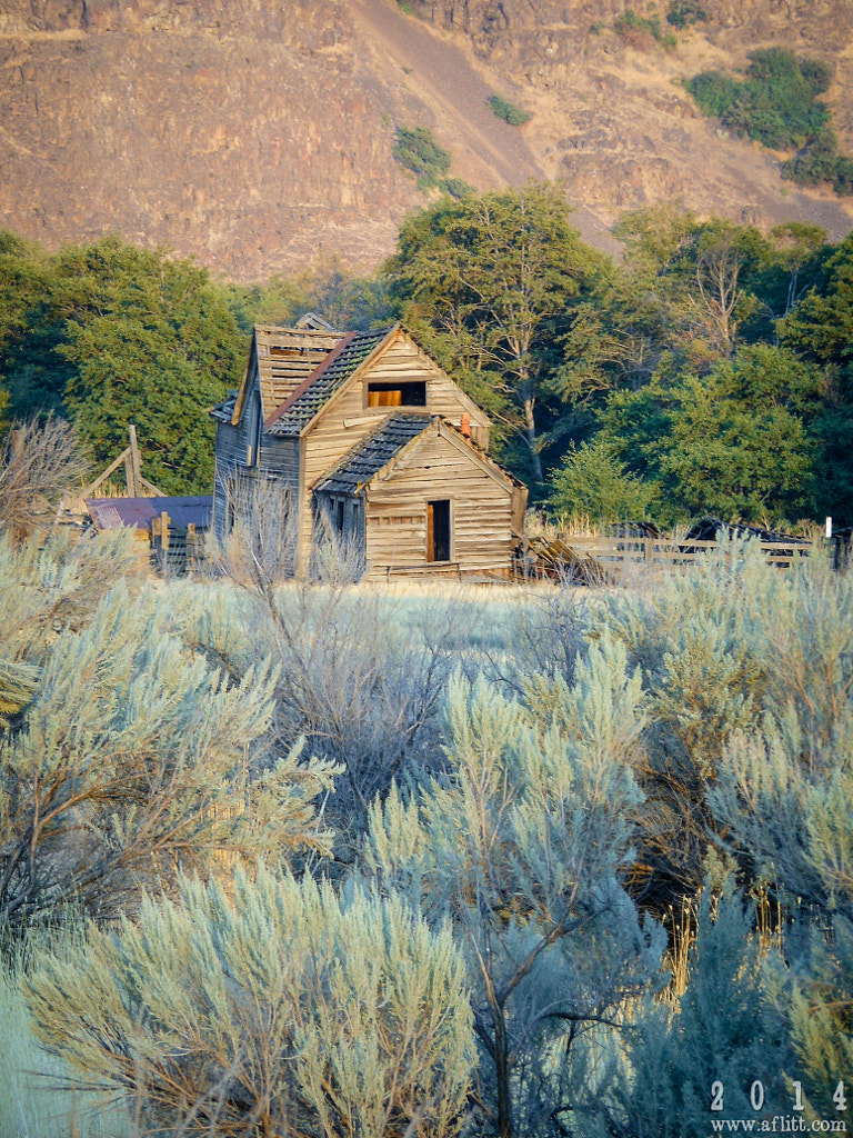
Harris Homestead, Deschutes River, & the Railroad Wars

Harris Homestead House and Sagebrush, 2014 by A. F. Litt on 500px.com

Harris Homestead House and Sagebrush, 2014
Deschutes River Trail. Sherman County, Oregon. August 19, 2014
Copyright © 2014 A. F. Litt, All Rights Reserved

Photo of the Day, not from the two week trip, but from the rafting trip from this week.  Now, I just had some ideas on how to proceed, nothing was promised!

On aflitt.com: http://www.aflitt.com/p9886877/e117bb13b
On 500px: http://500px.com/photo/80453407/harris-homestead-house-and-sagebrush-2014-by-a-f-litt
On Panoramio / Google Earth:  http://www.panoramio.com/photo/110755209

UPDATE:  August 21, 2014

One of the things I’ve been wanting to do with the renewed POTD is to write a little more about the photos I’ll be posting.  Unfortunately, yesterday I didn’t have time to do this. 
I took this photo while on a three day, father and son rafting trip with a group from our church.  We floated the Deschutes from Buckhollow, just below Sherars Falls, to Heritage Landing at the confluence with the Columbia.  We camped for the second night at the Fall Canyon campsite and, scouting around a bit after setting up our tent, I noticed the old homestead about a mile, more or less, up the river trail from our campground.

We didn’t have a chance to walk out there until later in the evening, right at sunset, and as we approached, I only had a few seconds to shoot with the house well lit with the last of the sun’s rays before it dipped below the ridgeline and left the ruins in shadows. 

While there was still plenty of light left to get some closer photos, this is the only nice shot I was able to capture of the house still bathed in the sunset glow.

I was able to get some neat shots though, both around the homestead and a little further down the trail at the old Deschutes Railroad Water Tower.  Went back again in the morning, as well, hoping for some sunrise light, but there were quite a few clouds in the sky and it was a rather pale and grey dawn.

The trip was spectacular, though the river was high so the rapids weren’t as exciting as we’d hoped.  But, since it was a whitewater rafting trip, I only took a point and shoot camera that stayed in its dry bag most of the time and a small, waterproof video camera that takes awful stills, so not that many photos came home with me.  Mostly a video trip, and I’ll be editing that footage and posting it sometime this fall.

Below is some more information about the area.  Follow the links for more details.

Deschutes River Maps:  http://www.boaterpass.com/ldrframe.htm
Harris Homestead - Hiking in Portland, Oregon and Washington:
At mile 10.9 is the Harris Homestead. There is a dilapidated farm house and dilapidated farm buildings. This area is currently being used for farming. The farmers used to live here, but now they live in The Dalles and drive here when needed. There are several farm fields and a building with some farm equipment like some irrigation and fencing stuff. On a typical day, a pickup or two will drive from the trailhead to here, do some work, and then drive back. Horses are allowed only to here. Beyond, only hikers and bikers are allowed.
Deschutes River Hike - Hiking in Portland, Oregon and Washington:
There are railroad and farm relics all along the trail. At mile 1, off the hikers trail next to the river, there's some sort of cable car that goes across the river. At mile 5.6 there's an old railroad car with an intact wood floor that might offer protection in inclement weather. At mile 6.6 is the remains of a bridge across the river (Free Bridge). There's one footing on the east side and another footing in the middle of the river. At mile 7.8 there's an old wood trestle and another railroad car. As of 2014, this car is now gone - I have to go see if there are any relics. At mile 10.9 is the remains of the Harris Homestead - a dilapidated house, some dilapidated farm buildings, a dilapidated cabin, and another farm building that has some current materials like hoses and fence posts.
...
This hike ends at the water tower just beyond the Harris Homestead at mile 11.3. Return the way you came. See Deschutes River from Macks Canyon Hike for a description of the next 11.8 miles to a trailhead at Macks Canyon.

Portland Hikers • View topic - Deschutes River Bike Camping Trip, April 23-24-25: (A nice picture of the campsite we stayed at and other photos.  Also, it appears the house was a bit more intact in  2010, the leaning bit in these photos is all the way down now!)
Fall Canyon is just one of the many campsites along the Deschutes that were set up primarily for rafters. We didn't see anyone rafting the river this weekend though. Afterwards we struck out to explore the eerie, yet strangely beautiful Harris homestead a mile down the pike…
Portland Hikers • View topic - Deschutes River Hike (April 5-7, 2012):
…about two hours later we arrived at the Homestead and started checking it out. The kids and dog even ran up stairs for a photo op. Us adults on the other hand decided to not push the limits of the old framing. We found some cool “artifacts”. We continued onto the water tower and had lunch there. On our way back there was a guy plowing the fields at the Homestead so we ran down and asked him why they were plowing the fields as this was a source of much discussion last night. The guy we spoke with (Mike) was super nice, he said they were planting Barley (he specified the type, but I don’t remember) because the deer and sheep really “love it”. With my curiosity satisfied we moved on.
http://www.portlandhikersfieldguide.org/wiki/Deschutes_River_from_Macks_Canyon_Hike

OregonTrunkRailroad:
One of the last railroad wars to occur, happened right  here in the state of Oregon.   In the end, the dispute was settled, but not after men died and property was damaged.  Today, one line lays abandoned and the other still in use.  This article will discuss primarily the abandoned Deschutes Railroad and it's remains, as well as the abandoned sections of the original Oregon Trunk.

The story is quite complicated, so what you will read here is a very abbreviated version.   In 1908, construction of two competing railroads was begun at the confluence of the Deschutes and Columbia Rivers.   The Oregon Trunk railroad was to connect with the Union Pacific on the south bank of the Columbia River, while the Deschutes Railroad was to connect with the Spokane, Portland & Seattle Railroad, located on the north bank of the Columbia River.

The Deschutes Railroad Company, a subsidiary of Union Pacific, was the first to take action on what was thought to be a lucrative railroad route.  Surveys were conducted as early as 1906 along the banks of the Deschutes River.  It was decided that the east bank offered the best route and the Deschutes Railroad began to survey and construct there.    Not long afterwards, the Oregon Trunk Railroad, which was incorporated in Nevada by investors from Seattle, with the sole purpose of running a railroad down the Deschutes, began its own surveys and construction along the west bank of the river.

Over the next few years, the railroads would be involved in numerous legal disputes over accessing the river canyon.   Specifically, because at several points along the route, both sides were competing for the same ground.   While railroad wars were common in the  1800s because railroad companies were often rewarded with more land, the quicker they could build, they had subsided by the 1900s.   However, the dispute between the Oregon Trunk and the Deschutes Railroad quickly deteriorated into essentially a railroad war.  One of the last to occur in the U.S.   Competing construction crews would often blow up each other's supplies and black powder stores, dump boulders on the camps and even get into gun battles!   Men were even apparently killed.  The local Sheriff had to get involved and made several arrests while enforcing court orders.

…
The first sectional abandonment occurred when the Oregon Trunk abandoned its line between South Junction and Metolius in 1923, and began using the Deschutes Railroad track from South Junction into Madras and Bend under a trackage rights agreement. This abandoned section had three tunnels, one of which still exists today and can be easily explored.
The next major abandonment occurred in 1935, when the entire Deschutes Railroad on the east bank from Moody to North Junction was abandoned.  The Oregon Trunk agreed to allow the Deschutes Railroad to use its better built line on the west bank and share costs of maintenance.   From this time forward, the railroad was essentially a single line operated
by two companies.  

…
Both the Oregon Trunk and the Deschutes Railroad originate from the south bank of the Columbia River.   The abandoned Deschutes Railroad originated from near the current site of Miller.  Nothing is left of Miller, but the line connected to the Union Pacific route that was already built on the west bank of the Columbia River.
…
Twin crossings is one of more interesting sites along the two railroad routes.  This is as far north as I've explored, so this photo featurebegins here.     This was one of the most contested build sites of both railroads, because both lines had to tunnel on the same side of the river right next to each other.  The tunnels would also be most significant in length of all the tunnels on the two lines, meaning the two competing crews had to spend a significant amount of time together.   A number of fights broke out and at one point one crew at to move their camp due to the blasting activities of the other crew.   Today, the Oregon Trunk tunnel and two steel bridges still survive today and are actively used by the BNSF/UP.  However, the Deschutes River tunnel was blasted shut sometime after 1935 when its line was abandoned.   When the Deschutes RR was converted to a road probably well after World War Two, the road was built over the site of the Deschutes tunnel, but a
few hints of the grade and some concrete abutments of small bridges can still be seen in the area.

…
As you can see, there is literally no hint of the Deschutes grade here.  Long covered by rock slides, probably from the road construction as it was built over the tunnel.   The two right photos are of the north bridge of the two bridges that crossed over the Deschutes River.   This is facing southwest.   Heading south on the west bank, the Oregon Trunk crossed the Deschutes river, entered its tunnel on the east bank and then crossed back over the Deschutes and continued down on the west bank again.  This route was chosen to keep the line as straight as possible
in this particular location.  In looking at the maps, it appears the S curve route that would have been the alternative wouldn't have been any more unusual that other S curves on the route, leading me to wonder if the site was chosen just as much as a provocation to the Deschutes RR as it was a strategic location.


Oregon Sheriffs - Sherman County:

On one side was James J. Hill, who first announced plans to help develop Central Oregon after visiting the Lewis and Clark Exhibition in Portland in 1905. Rumor had it Hill intended to build a railroad through Central Oregon, beginning at Bend and extending south to Klamath Falls and into northern California.

On the other side of the tussle was builder E. H. Harriman, who upon hearing the rumors of Hill's rail plans organized the Deschutes Railroad Co., and began surveying and filing maps of rights of way over government land in the Deschutes River canyon.

A man posing as sports fisherman John F. Sampson entered the picture a short time later and began buying up Options on wild lands and ranches throughout the Deschutes River Valley. He then approached William Nelson, the man who held controlling interest in a speculative, but non-existant railroad company called the Oregon Trunk Line, organized in 1906 in Nevada. Sampson bought Nelson's interests for $150,000.

It later was revealed that John F. Sampson was really John F. Stevens, the noted engineer behind the development of the Panama Canal and the Great Northern Railroad. Stevens had actually bought the Oregon Trunk Railroad for Hill, who furnished the funds to build the rail line through Central Oregon.

PaddleWise - Stories:
Competition was fierce with rival companies timing blasting to roll rocks into the path of the competition. Powder stores were located and exploded in sabotage night raids. In addition to the name-calling and rock throwing, shots were often exchanged. Coyote holes, shallow surface holes in the rock for black powder charges, often threw rock and debris across the river, endangering the competing crew. While clearing rock for coyote holes, the crew from Harriman's Des Chutes line discovered a large ball of rattle snakes huddled together to conserve body heat. The crew then spent several days sneaking burlap bags full of rattle snakes into the Oregon Trunk Railroad camp. Many of the Italian immigrants working for the Trunk Railroad under the supervision of contractor Harry E. Carlton packed and left the job.
At one point in the construction both companies posted riflemen on the ridges to cover the activities of their crews. One of these riflemen noticed sputtering sparks in the midst of sleeping workers. Closer inspection revealed a lighted fuse leading to a keg of black powder.


Related Posts

from tag history
(more..)