Showing posts with label rivers / creeks. Show all posts

Sunday, July 30, 2017

Glen Canyon National Recreation Area: Rincon from Space

The astronaut photographs ISS047-E-106206 — ISS047-E-106225 in this mosaic were acquired on May 7, 2016, with a Nikon D4 digital camera using a 800 millimeter lens, and are provided by the ISS Crew Earth Observations Facility and the Earth Science and Remote Sensing Unit, Johnson Space Center. The images were taken by a member of the Expedition 47 crew. The images have been cropped and enhanced to improve contrast, and lens artifacts have been removed. The International Space Station Program supports the laboratory as part of the ISS National Lab to help astronauts take pictures of Earth that will be of the greatest value to scientists and the public, and to make those images freely available on the Internet. Additional images taken by astronauts and cosmonauts can be viewed at the NASA/JSC Gateway to Astronaut Photography of Earth. Caption by Adam Voiland.
https://earthobservatory.nasa.gov/IOTD/view.php?id=88922


NASA Earth Observatory: A Curious Ensemble of Wonderful Features (October 16, 2016):
https://earthobservatory.nasa.gov/IOTD/view.php?id=88922

When John Wesley Powell explored the Colorado River in 1869, he made the first thorough survey of one of the last blank spots on the map. The expedition began in May at Green River, Wyoming, and ended three months later at the confluence of the Colorado and Virgin Rivers in present-day Nevada.
About two months into their journey, the nine men of the expedition found themselves in Glen Canyon. As the men traveled along the serpentine river channel, they encountered what Powell later described in Canyons of Colorado as a “curious ensemble of wonderful features.”
While the walls were not nearly as high in Glen Canyon as they were downstream in Marble Canyon or Grand Canyon, the explorers encountered a labyrinth of overhanging cliffs, hanging gardens, sweeping river bends, and natural arches set amidst a backdrop of colorful buttes and mesas.
“Past these towering monuments, past these mounded billows of orange sandstone, past these oak-set glens, past these fern-decked alcoves, past these mural curves, we glide hour after hour, stopping now and then, as our attention is arrested by some new wonder,” wrote Powell.
...


download large (full resolution) mosaic image (63 MB, JPEG, 11280x20492)


Links


Sunday, June 11, 2017

Austin Hot Springs on the Clackamas River

Austin Hot Springs and the Clackamas River
Mt. Hood National Forest.  Oregon.  July 6, 2016.
Copyright © 2017 A. F. Litt, All Rights Reserved
http://www.aflitt.com/mt-hood-nf

I threw a quick post up on the blog about this spot back in 2015 and mentioned that I'd update it with some photos when I had a chance to shoot some photos...  Well, that didn't happen until 2016, and now here it is, 2017 and, at this point, I decided just to make a whole new post!

This area is off-limits to the public. The spring itself is on private property, and there are the remains of a decommissioned PGE campground / park on the highway side of the river, which is private property, as well.

And why was the park closed?

These springs can have unexpected bursts of boiling water that can be very dangerous.

Not, ouch, that burns a little dangerous, but "hospitalized at Oregon Burn Center for two months and had three surgeries" type of dangerous.

The hot spring water runs into the river, and folks make their own "pools" in the river out of stones. Of course, the warmer you make your pool, the more at risk you are of getting scalded and boiled in a burst...

Oh, and apparently there are springs in the river too, not just these ones on the bank. Those are the ones that can send you to the hospital for months, apparently.

This is an interesting spot, but officially closed to the public and it's pretty dangerous, too. Not to mention that parking is a pain in the ass...

So, just stay away from this place.  It is interesting, but it is nasty.

See the links below for more information and photos of the stone rings in the river.

Austin Hot Springs
Mt. Hood National Forest.  Oregon.  July 6, 2016.
Copyright © 2017 A. F. Litt, All Rights Reserved 
http://www.aflitt.com/mt-hood-nf


Oak Grove project, party at Austin Host Springs
Photo by Portland General Electric, 1920 – 1925
Oregon Historical Society Digital Collections:
Portland General Electric Photograph Collection; Org. Lot 151; Box 15; PGE 16-44
Creative Commons - Attribution, Non-Commercial, ShareAlike (BY-NC- SA)
https://digitalcollections.ohs.org/oak-grove-project-party-at-austin-hot-springs

Video (By Others...)


Below is a visually interesting, long video in Russian. It has some interesting shots of the site in winter. Mute is fine if you do not understand the language.


Links


USFS:  

Mt. Hood National Forest Water Activities
Austin Hot Springs is on privately owned land and is not under Forest Service jurisdiction. The area is closed to public access and signs indicate the danger of soaking in the Spring's sometimes up to 200 degree water.
https://www.fs.usda.gov/activity/mthood/recreation/wateractivities
Trail Advocates of the Clackamas River Ranger District of the Mount Hood National Forest:


Warm Spring Tribes purchase Austin Hot Springs property (August 20, 2015)
Discussions so far point to extensive habitat restoration work to repair the effects of mismanagement in the past. 
... 
They intend to limit public use of the area which is bad news if you are one of the many who enjoys soaking there. They do not want to block people from using the area. However, they want to remove decades of rock placed to divert the river away from the springs by users. This will return the river to rapidly flowing right over the hot springs and make that nice hot soaking hole not be one. 
https://www.trailadvocate.org/sf-forum/historical-items-of-interest/warm-spring-tribes-purchase-austin-hot-springs-property

Oregonian/OregonLive.com: 

Troutdale woman severely scalded at Austin Hot Springs sues property owner for $2.8 million (June 15, 2010)
She was hospitalized at Oregon Burn Center for two months and had three surgeries. The near-boiling water left her with scarring on her torso, arms and hands, and legs and feet. 
http://www.oregonlive.com/clackamascounty/index.ssf/2010/06/troutdale_woman_severely_scald.html

Austin Hot Springs owner in hot water with regulators (December 13, 2008)
After four people were badly burned at the Clackamas River's only hot springs this fall, the owners brought in an excavator to try to discourage the soakers once more.
What happened next is in dispute.
But the ground truth is that many of the makeshift pools are now gone, a side channel considered prime salmon habitat is blocked with debris -- and the owners, the J. Frank Schmidt Profit Sharing Trust, are in hot water with environmental regulators.
... 
The site -- owned by Portland General Electric until burning incidents prompted the utility to sell it in 1985 -- still has several unauthorized concrete-edged pools left, complete with piping to let cool water in and hot water out. 
...  
Michael Rysavy, president and chairman of the Northwest Forest Conservancy, has helped tend nearby Bagby Hot Springs and Austin for years, helping pluck out thousands of pounds of trash and cut crime at the springs. He met his wife at Bagby, and together they've visited about 150 hot springs sites.
He has a plan to make the hot springs a legitimate destination.
The 32-year-old Clackamas Realtor is trying to raise $1 million in the next year from donors and investors to buy the 152 acres of private land that includes Austin Hot Springs. He hopes to buy it for $700,000, using the remainder to begin restoring the site.
http://www.oregonlive.com/environment/index.ssf/2008/12/austin_hot_springs_owner_in_ho.html
Think before you dip into one of Oregon's hot springs (September 11, 2008)
The volcano-fueled heat at Austin Hot Springs has long been a known danger that led to an Oregon Supreme Court case more than two decades ago. 
Hot springs also can harbor rare and bizarre invisible hazards such as staph bacteria, arsenic and even a deadly amoeba that enters through your nose and eats your brain.
...there's no reliable way to mix in the right amount of cool Clackamas River water to prevent burns as scalding water surges out of the ground into homemade pools without warning. 
http://www.oregonlive.com/news/index.ssf/2008/09/think_before_you_dip_into_one.html
Facebook Page:
https://www.facebook.com/pages/Austin-Hot-Springs/298895600216873

Instagram:
https://www.instagram.com/explore/tags/austinhotsprings

Oregon Hot Springs:
At 186ºF the water at Austin Hot Springs is extremely hot, and the utmost care needs to be taken in making sure not to burn yourself while finding an area comfortable enough to soak.   
As mentioned above, the springs are very hot and need to be mixed with river water in order to be comfortable enough for soaking. Depending on season, river height, and use, there will likely be several rock rings built for just such a purpose. These rings create tolerable pools, but be sure to test the temperature to find one you can bear. You may need to mix the water as well.
Many thanks go out to the Northwest Forest Conservancy for making this site usable.
http://oregonhotsprings.immunenet.com/austin.htm
SoakOregon.com - Austin Hot Springs:
Please be aware of Austin’s 200+ degree bursts of hot water and use extreme caution when soaking in this spring. There are suitable spots to soak, just be very careful to not scald yourself. A waterproof digital thermometer can help locate burst zones.
Posted 4/19/2012:
"This natural hot spring, heated by volcanic activity, sits in and along the Clackamas River, among the pristine trees of the Mt. Hood National Forest. There could be several rock pools along the river suitable for qualification depending on the season. Please be aware of Austin’s 200+ degree bursts of hot water and use extreme caution when soaking in this spring. There are suitable spots to soak, just be very careful to not scald yourself. A waterproof digital thermometer can help locate burst zones." 
"...J. Frank Schmidt now owns the land. PGE had it in the 60’s and 70’s, where it once had a campground. But PGE closed the campground in the late 70’s because Russian immigrants were living there full time and threatening others who attempted to camp there. PGE turned it into a day use only park for a few years. After a few lawsuits in the early 80’s for people being scalded, PGE closed the park and tore out the footbridge. They then sold the property. Schmidt bought it hoping to develop it into another Brightbush Resort type location… but failed to gain the permits and codes to do such. After being sued twice, he took measures to make access to the area difficult. It has been up for sale for at least 3 years now, but he is wanting too much for it."   
http://soakoregon.com/austin-hot-springs/

Tuesday, August 09, 2016

Yellowstone National Park: Kepler Cascades

Kepler Cascades
Firehole River.  Yellowstone National Park.  August 2, 2014.
http://www.aflitt.com/yellowstonenp/e7dd6fe64
Copyright © 2016 A. F. Litt, All Rights Reserved

Photo of the Day by A. F. Litt: August 9, 2016


I've been buried in video work, both shooting and editing, since my last, true "photo of the day" post, but I wanted to take a few minutes to sneak one in today.  No time for much writing, so here's a quick waterfall shot.  Until next time...

Links


Wikipedia: https://en.wikipedia.org/wiki/Kepler_Cascades


Thursday, July 21, 2016

Natural Bridges National Monument: Sipapu Bridge

Sipapu Bridge
Natural Bridges National Monument.  Utah.  May 13, 2016
http://www.aflitt.com/naturalbridgesnm
Copyright © 2016 A. F. Litt, All Rights Reserved

Photo of the Day by A. F. Litt: Day of Several Photos - July 21, 2016


Let's get this out of the way quickly...  Arches are dry; natural bridges are over water.  That's the main difference.  Because of this, the erosional processes that lead to their creation are a little different.  Generally, natural bridges form where creeks and rivers erode through the walls of incised meanders (think of the Goosenecks in the San Juan River...  in fact, bridges may eventually form there!), while arches are usual formed by erosion from wind, rain, and freeze/thaw cycles.  This is why bridges are usually in canyons and arches are usually up high on cliffs and fins.  Of course, this is the most basic geologic explanation possible, there are whole books on this stuff, but it should suffice.

Under Sipapu Bridge (Panorama)
Natural Bridges National Monument.  Utah.  May 13, 2016  
http://www.aflitt.com/naturalbridgesnm 
Copyright © 2016 A. F. Litt, All Rights Reserved
At Natural Bridges National Monument, you must hike the canyons!  Period.  No excuses.  The views are fine from the scenic Bridge View Drive, and worth checking out, but to really understand the scale of these things one must climb down to them, stand under them, sit in their shade on a hot day...  Of course, if you only have time for the drive, it's still worth a visit, but know that it is just not the same.

Unfortunately, I broke a huge rule of hiking when I climbed down into the canyons at Sipapu.  I accidently left my map behind and wandered down the wrong canyon at Kachina Bridge.  The trails in the canyons are vague at times, and a vague trail led down White Canyon when the actual trail climbed up into Armstrong Canyon where Owachomo Bridge is located.  I was lucky that the vague trail turned into no trail pretty quickly and the rough terrain around the creek grew so difficult (not impassable, by any means, but tough enough to suggest to me that I was off trail) that I finally figured it out and turned around.

The detour, though, burned too much time and energy, so I climbed out of the canyon at Kachina and took the overland trail back to the Sipapu Trailhead.  I shall return, sooner than later, I hope, to finish the hike.

Oh, and a "pro tip."  Park where you want to end your hike and then take the overland trail to the trailhead where you want to descend.  The trail is nice enough, pretty enough, but, well, its boring compared to the canyon, and it sucks hiking it when you are hot and tired and done.  I suspect the rangers tell people to do this at the Visitor Center, but I failed to talk to them about this hike before I dove in...  Another oops.

As for the bridge...  This is the biggest in the park, the second biggest natural bridge in the U.S. (after Rainbow Bridge), and the fifth largest arch in the U.S.  It was originally reported (1908) to have a span of 268 feet and a height of 167 feet, which would have made it the seventh largest natural arch in the world, but revised measurements (2007) put the span at approximately 225 feet and a height of approximately 144 feet.  Rankings of size are disputed, but The Natural Arch and Bridge Society currently ranks Sipapu as the 13th largest arch in the world (based on span), and, by my count off of their list, the seventh largest natural bridge in the world.  

Wikipedia points out, "Since the closure of the trail leading under Landscape Arch due to safety concerns, and the voluntary prohibition placed on passing under Rainbow Bridge in deference to (often debated) Navajo and Hopi spiritual beliefs, Sipapu is now the longest natural arch in the world to have an active trail beneath it that visitors may pass under, affording spectacular views of the underside of the arch."  This is not entirely correct based on updated measurements of several arches and bridges in China, but you would have to travel to China or Chad to walk under a larger one.

The name Sipapu comes from the Hopi word for the opening between worlds that the people emerged from in many Indian creation myths.  It was first named President in 1883 and Augusta in 1904.  The Sipapu name "was given by William Douglas, who led a government survey party to the bridges in 1908, mapping the exact boundaries of the new national monument." (NPS)


NPS - Natural Bridges National Monument
https://www.nps.gov/nabr/index.htm

Smith River National Recreation Area

Middle Fork of the Smith River
Smith River National Recreation Area. California. August 25, 2012.
Copyright © 2013 A. F. Litt, All Rights Reserved

I think both of these photos have been up as Photo of the Day back during the early days of that on-going project, so I am not posting them as Photos of the day for today...

Just a couple of quick notes on this National Recreation Area.  It was designated by Congress in 1990 and is managed by the United States Forest Service (Six Rivers National Forest).  We camped there between the Oregon Caves and the Redwoods in 2012, but did very little exploring in the Recreation Area itself.

Wikipedia says that this "area is considered one of the best fishing regions in the U.S."


Natural Lighting
Grassy Flat Campground.  Smith River National Recreation Area.  California.  August 25, 2012.
http://www.aflitt.com/smithrivernra
Copyright © 2013 A. F. Litt, All Rights Reserved


Links


USFS - Smith River National Recreation Area
http://www.fs.usda.gov/recarea/srnf/recarea/?recid=11440

Wikipedia
https://en.wikipedia.org/wiki/Smith_River_National_Recreation_Area

L. A. Times - A California Time Capsule : Pristine Version of State Awaits in Smith River Recreation Area (1991)
http://articles.latimes.com/1991-04-10/sports/sp-238_1_smith-river-national-recreation-area

Tuesday, July 19, 2016

North Chimney Rock In Firehole Canyon

North Chimney Rock In Firehole Canyon
Flaming Gorge National Recreation Area. Wyoming.  August 12, 2014
Copyright © 2016 A. F. Litt, All Rights Reserved
http://www.aflitt.com/flaminggorgenra/e73350960

Photo of the Day by A. F. Litt: Day of Several Photos - July 19, 2016


This was the last stop on a long, two week trip through many states back in 2014.  We rolled all the way across Wyoming the night before, traveling from Scotts Bluff, Nebraska along the old Oregon Trail route, past Independence Rock, and arriving at the Firehole Canyon Campground sometime around midnight or later.   

Originally the plan was to drop down US 191 to Vernal, Utah and Dinosaur National Monument, but first we headed back up to I-80 and civilization in search of breakfast, which we were all too burned out to cook ourselves that morning.  Once back out on the freeway, I realized that we were a day's drive (true, a very long day's drive, but do-able) away from home, and we decided to cut the trip a day short and to sleep in our own beds that night.

I still haven't made it back to Dinosaur...  I've been there a couple of times before, many, many years ago, when I was a kid.  On one of these Southwest trips over the next couple years, I hope to take my kids there to visit.

As for Flaming Gorge, this spot is pretty nice, as you can see.  It's about all of the area we got to explore, though, since the whole family was pretty tired and it was time to go home.

As I wrote in the last post, Today, I plan on burning through several photos, filling in some of the gaps in the National Parks section of the website (http://aflitt.com/NationalParks). I am not sure how many I will get through, but there should be several "photo of the day" posts today.

Firehole Canyon Panorama
Flaming Gorge National Recreation Area. Wyoming.  August 12, 2014  
Copyright © 2016 A. F. Litt, All Rights Reserved

Links


USFS
http://www.fs.usda.gov/detail/ashley/specialplaces/?cid=stelprdb5212203

Wikipedia
Flaming Gorge NRA: https://en.wikipedia.org/wiki/Flaming_Gorge_National_Recreation_Area
Flaming Gorge Reservoir: https://en.wikipedia.org/wiki/Flaming_Gorge_Reservoir

Utah.com
https://utah.com/flaming-gorge

Monday, July 18, 2016

Grand Canyon: View East From Navajo Point

View East From Navajo Point
Grand Canyon National Park. Arizona. March 25, 2016.
Copyright © 2016 A. F. Litt, All Rights Reserved
http://www.aflitt.com/GrandCanyonNP/e76283296

Photo of the Day by A. F. Litt: July 18, 2016

We ended up spending a lot of the time on the trip that we wanted to spend at the Grand Canyon at Zion, instead. However, it was a pretty good choice. I'd never been to Zion before, but this was my second visit to the Grand Canyon. Sure, it was when I was seven, but we spent several days on the south rim, one or two days on the north rim, and the memories are solid.

This time, it was a very short visit.  The park was mobbed, and we wanted to hit Meteor Crater on the way to Tuscon, our final destination of the day (it was a long day).  We came into the park through the Desert View Entrance, checked out the Desert View Watchtower (visible, in the distance, on the rim in the photo), hit a couple viewpoints, spent an annoying half hour or so looking for parking at Grand Canyon Village, and then moved on...  

Links

NPS - Grand Canyon National Park: https://www.nps.gov/grca/index.htm


Thursday, November 19, 2015

1781 Buried Forest at Oxbow Regional Park

A. F. Litt: Gresham &emdash; Uncovered Stumps From Old Hood Eruption (2010)

Uncovered Stumps From 1781 Eruption of Mt. Hood (2010)
Oxbow Regional Park. Oregon. March 20, 2010.
Copyright © 2015 A. F. Litt , All Rights Reserved


Photo of the Day by A. F. Litt: November 11, 2015

For today's photo I went a little random into the old files and landed in some shots I took in Oxbow Regional Park back in 2010.    What's cool about this shot is that you can see the stumps buried in Mt. Hood's 1781 Old Maid eruptions emerging.  After some major storms over the next few years, much more of this bank was eroded away revealing many more of these old trees.  These stumps first came to attention in 2013, but this photo shows that some were already starting to poke out a few years earlier... 


For more information:

Sullivan, William. "Sandy River uncovers a forest buried by Mount Hood in 1781". The Statesman Journal. Apr. 20, 2013

2014 Bretz Club Field Trip Materials Sandy River, Oregon April 10-12, 2014. Oregon State University.

Tuesday, April 21, 2015

Austin Hot Springs

UPDATE - June 11, 2017:
Made a new post on these springs here http://rubble.blogspot.com/2017/06/austin-hot-springs.html

--------------------------------------------------

Always been curious about this rather mysterious spot on the Clackamas River. I'd tried Googling it, but never knew the name until today when I stumbled on a picture on Google Earth...

Austin Hot Springs | SoakOregon.com:

"Approximately 60 miles outside of Portland along Highway 224 lies Austin Hot Springs. This natural hot spring, heated by volcanic activity, sits in and along the Clackamas River, among the pristine trees of the Mt. Hood National Forest. There could be several rock pools along the river suitable for qualification depending on the season. Please be aware of Austin’s 200+ degree bursts of hot water and use extreme caution when soaking in this spring. There are suitable spots to soak, just be very careful to not scald yourself. A waterproof digital thermometer can help locate burst zones." 
"If YOU were paying attention... you’d know that J. Frank Schmidt now owns the land. PGE had it in the 60’s and 70’s, where it once had a campground. But PGE closed the campground in the late 70’s because Russian immigrants were living there full time and threatening others who attempted to camp there. PGE turned it into a day use only park for a few years. After a few lawsuits in the early 80’s for people being scalded, PGE closed the park and tore out the footbridge. They then sold the property. Schmidt bought it hoping to develop it into another Brightbush Resort type location… but failed to gain the permits and codes to do such. After being sued twice, he took measures to make access to the area difficult. It has been up for sale for at least 3 years now, but he is wanting too much for it. [Posted 4/19/2012]"

I might be out that way today and I'll grab some pictures if I am (wasn't poking around there on Google Earth for no reason!), but plans aren't set in stone yet.  If not, I'll dig and see if I can find some old pictures from here and update this post.

Saturday, January 03, 2015

Misty Gray Day on the Historic Columbia River Highway

A. F. Litt: HCRH State Trail - John B Yeon State Park to Moffett Creek &emdash; Beacon Rock and Old Utility Pole from New Trail

Beacon Rock and Old Utility Pole from New Trail
HCRH State Trail. September 15, 2013
Copyright © 2014 A. F. Litt , All Rights Reserved

Photo of the Day by A. F. Litt: January 3, 2015

I don’t have much time today, so I am not posting a “new” picture, but one that has been on the Recreating the Historic Columbia River Highway site for a month or so…  I first posted it there while I was on break from the Photo of the Day, but I almost went ahead and did a one off POTD post at the time, I liked this photo so much.

It is shot from the new HCRH state trail looking down towards actual location of the old highway, with one of the few old utility poles that still mark the course of the original route.  This was one of the grayest of drizzly Oregon autumn gray days, but it was very nice.  The new State Trail was not officially open yet (traffic was allowed on this one weekend only for the dedication ceremonies) and the final small details were still under construction. 

Being late in the day on Sunday, I had the whole trail to myself, and it was a very nice walk that afternoon, alone in the mists, with the peaks "...like sentinels in the Gorge of the Columbia. The clouds play[ing] 'hide and seek' around their heads, and the eagles mak[ing] their nests among the crags." 

For more information: http://www.recreatingthehistoriccolumbiariverhighway.org/john-b-yeon-state-park-to-tanner-creek

On www.aflitt.com: http://www.aflitt.com/hcrh-statetrail-yeontomoffett/e38762c64

On 500px: https://500px.com/photo/94510025/beacon-rock-and-old-utility-pole-from-new-trail-by-a-f-litt

Related Posts

Thursday, January 01, 2015

An Icy End to 2014

A. F. Litt: Columbia River Gorge National Scenic Area &emdash; Icy Horsetail On New Year's Eave, 2014

Icy Horsetail On New Year's Eve, 2014
Historic Columbia River Highway. December 31, 2014
Copyright © 2015 A. F. Litt, All Rights Reserved

Photo of the Day by A. F. Litt:  January 1, 2015

Well, it’s a new year and it’s time to start up the POTD again.  I could discuss plans for the year, plans for the POTD project, plans for the Recreating the Historic Columbia River Highway project, plans for photography and filmmaking, plans for my family…  All swirling through my head. 

But it is a new year and who knows what God will bring us, so instead, a nice picture from the frozen Gorge yesterday. 

Time to watch some football.  There will be more time for all of this other stuff later.

Happy New Year!  Make it a great one!

On 500px: https://500px.com/photo/94294797/icy-horsetail-on-new-year's-eve-2014-by-a-f-litt

On www.aflitt.com: http://www.aflitt.com/p970430128/e2d636534

Related Posts

Wednesday, October 08, 2014

Devil’s Canyon Overlook, Bighorn Canyon NRA

A. F. Litt: Bighorn Canyon National Recreation Area &emdash; Devil's Canyon Overlook, Bighorn Canyon NRA

Devil's Canyon Overlook, Bighorn Canyon NRA
Bighorn Canyon National Recreation Area. Montana / Wyoming. August 5, 2014
Copyright © 2014 A. F. Litt, All Rights Reserved

Photo of the Day by A. F. Litt:  October 8, 2014

According to the National Park Service, this is the “Grandest Canyon in the Northern Rockies,” featuring:

A landscape of sheer cliffs towering 1,000 feet above a ribbon of blue water. World class fishing and a place where wild horses still run free. Bighorn Canyon is a place where imagination meets reality. Bighorn Canyon has unrivaled recreation possibilities.

http://www.nps.gov/bica/index.htm

So I’m back to the summer trip photos today…  Hopefully back on track with mostly daily posting, as well.

This was one of the few “new to me” location we visited on this trip, and it was a nice one.  We didn’t know much going in, just saw it on the map and decided to go, and it was a great side trip.  We saw wild horses, old homesteads, and, well, the canyon you see above.

I’d love to find a pre-1967 photo of the canyon before the completion of Yellowtail Dam.  The river was still high enough for boats, but there was a bit more whitewater down there.  There are some interesting stories about the boat trip into some ranches that lie in the heart of the NRA.

But I need to keep things short today.  More material to explore in later POTDs when I have a bit more time (hopefully).

On www.aflitt.com: http://bit.ly/1t32ZJj

On 500px: https://500px.com/photo/85806749/devil's-canyon-overlook-bighorn-canyon-nra-by-a-f-litt

Related Posts

Thursday, May 22, 2014

Two or Three Waterfalls on Lindsey Creek?

Lindsey Creek

Acoustics can be strange, and the landscape, when seen from different angles, deceptive.  Points reached by different routes can be confusing…  

Lindsey Creek has two waterfalls for sure, Harrison Falls, actually visible from I-84 when the leaves are down in the winter, if you know where to look, and Lindsey Creek Falls. 

But I am not entirely sure that these are the only two.

 
Harrison Falls on Lindsey Creek (2013)
Columbia River Gorge National Scenic Area. Oregon. November 1, 2013.
Copyright © 2014 A. F. Litt, All Rights Reserved

The lower waterfall is sometimes called Lower Lindsey Creek Fall, but more and more it’s old name is returning to use, Harrison Falls.

... This waterfall [Lindsey Creek Falls] was called Harrison Falls early in the 20th century. After the original Columbia River Scenic Highway was built, a number of auto camps were built along the new road. The one that operated at Lindsey Creek was known as Harrison's Auto Camp. No trace of it remains.

Doug Gorsline, "ashcreekimages.com" website, 2013 (Via columbiariverimages.com)

... Early postcards have this waterfall captioned as "Harrison Falls", or "Harrison Falls near Harrison Auto Camp, Columbia River Highway". I suspect this is simply a historic unofficial naming. ...Harrison Falls is the Historical name of this waterfall.

Known Alternate Names: Lower Lindsey Creek Falls.

Bryan Swan, "waterfallsnorthwest.com" website, 2013 (Via columbiariverimages.com)

It is easily reached by pulling off the eastbound freeway at the large turnout east of Lindsey Creek, where the old auto camp apparently was located. 

Lindsey Creek Turnout, Looking West (2013)

Columbia River Gorge National Scenic Area. Oregon. November 1, 2013.
Copyright © 2014 A. F. Litt , All Rights Reserved


Columbia Gorge Discovery Center Photo Archive
Catalog Num: 1999.13.94P
Condition: Good
Date:
Location: The Dalles, Oregon
Title:
Content: No. 52. Harrison's Auto Camp, Columbia River Highway
Other Notes: description from above on front.no correspondence
Photographer: B.C. Markham, The Dalles, Oregon
Copyright:
http://www.gorgediscovery.org/photoarchive/newDetails.asp?offset=970&ID=2695

Today, nothing remains of the scene pictured above. Decades of flooding have wiped out not only the site of this camp but also the picnic area that was near Lindsey Creek until the 1960s.


Approximate Site Of Harrison Auto Camp and Picnic Area (2013)

HCRH. Columbia River Gorge National Scenic Area. Oregon. November 1, 2013.
Copyright © 2014 A. F. Litt , All Rights Reserved

There is a sort of trail to the falls leading up the east bank of the creek, though it may require getting wet here and there (in November, at least, when I was there last).  Good views can also be found on the slopes above the west bank, at least when the leaves are down.  This is where I shot my photo of these falls from.

This area was also the original trailhead for the Mt. Defiance trail(https://www.flickr.com/photos/21209133@N06/sets/72157627002746570/). 

Harrison Falls (2013)
Columbia River Gorge National Scenic Area. Oregon. November 1, 2013.
Copyright © 2014 A. F. Litt, All Rights Reserved

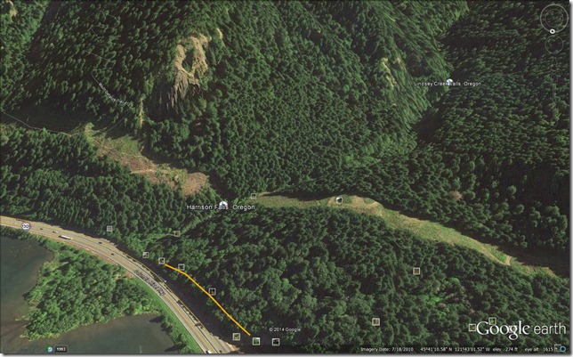
Still, looking at the map above, it seems like Harrison Falls may be marked a little too far upstream.  Standing on the west side of the ravine above, though, under the powerlines, one can hear Harrison Falls towards the freeway, but it sounds like there is another large waterfall upstream from it to the south, best heard from the south edge of the powerline clearing.


Above a waterfall?
Sure sounds like it, but it is tricky and dangerous getting much closer than this. Upstream from Harrison Falls so I think this is a different one.  There is a third further to the south, but I suspect this is the big one on Lindsey Creek, it's quite a drop between the valley on the right and the ravine on the left.
Columbia River Gorge National Scenic Area. Oregon. November 1, 2013.

Not quite sure what is down there, and at first I thought it was the waterfall Scott Cook calls Lindsey Creek Falls in his book Pokin’ Round The Gorge, but reading the directions to that waterfall a little more closely, and then tracing them out on Google Earth, this is starting to sound more like the one marked on the map above and one I’ve glimpsed from the Lindsey Creek Road, which is marked in blue on the map below.

Jess - Lindesy Creek Road
Map by Paul Jess. 
https://www.flickr.com/photos/21209133@N06/5851360195/in/set-72157627002746570

"Upper" Lindesy Creek Falls (2013)
"Upper" Lindsey Creek Falls from the old Lindsey Creek road grade (2013)
The perspective in the photo above is a bit strange, since it looks like it was taken from the west side of the ravine, but due to the meandering nature of the creek and the high power zoom, this is just an illusion, this was taken from the east side of the ravine.
Columbia River Gorge National Scenic Area. Oregon. November 1, 2013.
Copyright © 2014 A. F. Litt , All Rights Reserved

Cook’s directions to the falls start at the same location as Curious Gorge Hike #32: Summit Falls/Historic Highway Loop (pg. 76, 2012 edition), but then following the BPA access road’s east fork towards Lindsey Creek.

Follow the double track to the last tower, cut left around it then swing to the right, under the lines and over the sticks into the forest.  Pick your way on the old roadbed for a minute until you see a rough trail climbing down to the left.  Follow this down then angle upstream and bushwhack over to the creek … and take note of where you are so you can find it on the way back!  Now you begin to splash, bob, weave and hop for 8-9 minutes to the falls.

           Scott Cook.  Pokin’ Round the Gorge.  Hood River, OR: Scott Cook. 2008. 81.

Roughly recreating his directions in Google Earth leads to a map that looks like this, though in November 2013, few traces of the roads Cook describes were visible.  The route below is speculative, so please use caution if attempting to follow it, and it is based on a combination of Cook’s directions and my own experience in the area.
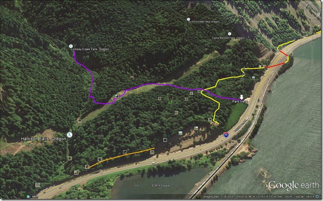
Upper Lindesy Creek Map

His photo of the falls themselves graces the cover of the book.  There are more inside, but due to the nature of that book, and this site, this is the only one I’m comfortable posting!

Lindsey Creek Falls

So, is there a hidden “Middle” Lindsey Creek Falls?  There could be.  Cook’s directions to the upper falls seems to bypass the area where the sound of a waterfall is coming from.  Also, zooming in a bit on Google Earth, there sure seems to be at least one waterfall down there that looks at least as large as Harrison Falls. 

Middle Lindsey Creek Falls
Click to enlarge…

One of these days I’ll pick my way down into that ravine and find out, unfortunately, the last time I was there I was by myself, it was getting late, and nobody really knew where I was if something went wrong, so I was playing it really safe and taking no risks.  But I think this summer, tramping up and down the creek on a hot summer day may be a fun adventure! 

I’ll update with what I find!

Update – Like 15 minutes later…

I need to remember to hit Google before I hit send…

A good thread (with great pictures) on Lindsey Creek.  Probably not a big “middle” falls in there, just lots of whitewater essentially making the whole stretch one big falls.  But there are more falls upstream from Lindsey Creek Falls.

Lindsey Creek 8 23 2011: http://www.portlandhikers.org/forum/viewtopic.php?f=10&t=9227

More on the Lindsey Creek Falls:

http://www.portlandhikers.org/forum/viewtopic.php?f=10&t=18797

Related Posts