Showing posts with label Vermilion Cliffs National Monument. Show all posts

Monday, June 26, 2017

Vermilion Cliffs National Monument: 27 Monuments Stop #6

Peaks, Cliffs, and Highway
Vermilion Cliffs National Monument. Vermilion Cliffs, Utah. March 25, 2016.
Copyright © 2017 A. F. Litt, All Rights Reserved
http://www.aflitt.com/vermillioncliffsnm
https://sites.google.com/view/nationalmonumentsindanger/monuments/vermillion-cliffs


National Monuments in Danger

https://sites.google.com/view/nationalmonumentsindanger/home


I've been on the road myself, so I've fallen a bit behind on tracking Brent Rose's travels across the country, but I hope to get caught up on some posts today.

As I wrote some time ago, I "missed" this monument on my travels last year.  We drove a few miles from our campsite at Lee's Ferry in the Glen Canyon National Recreation Area to "count coup" on this monument and to take a couple pictures of the cliffs, but then rolled on to the Grand Canyon.

In hindsight, our time would have been more enjoyable spending some time here, rather than taking a couple quick shots of the canyon while dealing with the crazy crowds for a few hours at the south rim.

Unfortunately, it was March and all the visitor centers were closed before we made it to them, and we didn't realize how much there was to do in the area until it was way too late.


The Wave is by far the most famous landmark here, and difficult to gain permits to visit.  But there are other similar features and many slot canyons, I understand, worth checking out, some requiring a desert backpacking adventure, but others more easily accessible (at least with a proper vehicle). "Though located only a few miles from Lake Powell and its legions of pleasure craft, the 300,000 acres encompassed by the monument are no place for the fainthearted or unprepared," explains a 2012 article in National Geographic, where I first heard of this monument. "'Exit the car, enter the food chain,' quipped one official with the Bureau of Land Management, which administers the monument."

National Geographic: Vermilion Cliffs National Monument (February 2002)

Directly in front of you rises a chaos of rock vaulting nearly 3,000 feet—the Vermilion Cliffs. The cliffs can hardly be said to have a face. They have innumerable faces, fractured and serrated, crosshatched and slumped. You can feel the inertia in their colossal vertical fissures. Along the lower wedding cake tiers, rubble piles resemble the sand in the bottom of an hourglass. 
And now the question: How long would you have to wait until the Vermilion Cliffs calved a boulder the size of a school bus, say? The answer: It could happen the day you sit down. But it's likelier that your descendants' descendants would still be sitting in that chair, many hundreds of generations later, waiting for the cliffs to crumble a little more. The rock is ancient, and so are the traces of erosion. 
http://ngm.nationalgeographic.com/2012/02/vermilion-cliffs/klinkenborg-text 

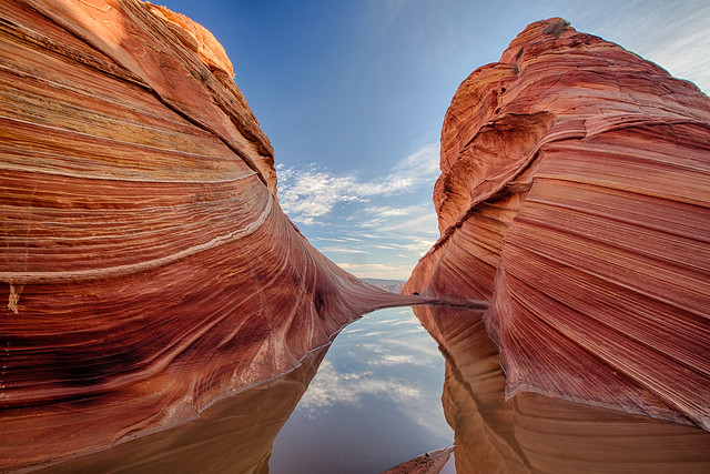
While the cliffs are spectacular, in many ways this monument should be called the Paria Plateau National Monument.  The cliffs them selves have been protected by Congress as a wilderness area since 1984, but the plateau above the cliffs is what is at risk in this process, and the Paria Plateau, by all accounts, is an amazing place.

Vermillion Cliffs NM


From the National Geographic article:
The Paria Plateau and its hem of cliffs were named a national monument by presidential proclamation in the year 2000, primarily in recognition of the exquisite archive of erosional forms—timescapes, windscapes, gravityscapes, and waterscapes but above all, sandscapes. There is the sand of the present day: the grit in your teeth, the slip-sink footing, the slithering tire-bog along the tracks in the Sand Hills mid-plateau. That sand (ancient enough, grain by grain) is derived from prehistoric sand—the Navajo sandstone that forms the plateau and cliffs. This sandstone, in turn, is the remains of a vast erg, a windblown sea of dunes that for millions of years covered most of what is now the Colorado Plateau. The geology is hard to imagine. It becomes even harder if you're lucky enough to come upon the Wave, hidden away in the northwest corner of the monument in a place called Coyote Buttes. 
The Wave is a tumult of striped, fossilized dunes that look like petrified surf, forever rising and curving, towering just short of breaking. What's been left behind by long ages of erosion—rogue waves of smooth, banded sandstone in a bowl of light—is a record of chemical reactions taking place as the sandstone developed, with patterns of bleaching and the depositing of iron oxide and other minerals. In its sinuousness, the Wave forms a wind siphon, its geometry accelerating the wind the way a high, curving track accelerates a skateboarder. 
... 
To safeguard this extraordinary formation, the BLM admits only 20 people a day to the Wave, so you're left nearly alone in a wilderness containing a geological "Mona Lisa." This isn't the South Rim of the Grand Canyon, a scenic view shared with thousands. Here is the intimacy of the senses: the abrasion of stone, the scent of rain on rock, a kaleidoscopic light that can leave you bewildered by the minute speck of time you occupy in the presence of so much frozen time.

National Geographic: Richard Barnes' Photo Gallery of Vermilion Cliffs National Monument:
http://ngm.nationalgeographic.com/2012/02/vermilion-cliffs/barnes-photography


BLM: Vermilion Cliffs National Monument Map (as of June 2017) - PDF


To comment on the monument review process (due July 10, 2017):


Links


27 Monuments:

Website
https://www.27monuments.org

Facebook
https://www.facebook.com/27Monuments

Instagram
https://www.instagram.com/brentdangerrose
https://www.instagram.com/explore/tags/27monuments


Rubble: Vermilion Cliffs


Wednesday, September 14, 2016

Vermilion Cliffs National Monument: Vermilion Cliffs

Vermilion Cliffs
Paria Canyon-Vermilion Cliffs Wilderness / Vermilion Cliffs National Monument.  Arizona.  March 25, 2016
http://www.aflitt.com/vermilioncliffsnm
Copyright © 2016 A. F. Litt, All Rights Reserved


Photo of the Day by A. F. Litt: September 14, 2016 


I stuck a number one on yesterday's post, but wrote too much and did not have time to post any additional photos.  Today, I know I only have time for one.  

This is shot from just off Highway 89A between Marble Canyon and township of Vermilion Cliffs, so it is not necessarily in the national monument itself, and may actually show only the Paria Canyon-Vermilion Cliffs Wilderness that rings the monument, but does show the cliffs.  From where this is shot, the cliffs rise some 3,000 feet to the Paria Plateau above.  

Up there on the plateau, there are some spectacular sights, from what I understand.  A few years back National Geographic published an article on this monument, and the photos were amazing.  It is worth tracking down.

It's hard to get a sense of scale in these photos.  This is one of the more dramatic steps of the Grand Staircase.

Vermilion Cliffs and U. S. 89A
Paria Canyon-Vermilion Cliffs Wilderness / Vermilion Cliffs National Monument.  Arizona.  March 25, 2016  
http://www.aflitt.com/vermilioncliffsnm
Copyright © 2016 A. F. Litt, All Rights Reserved

Interpretive Sign - Paria Station
Paria Contact Station.  Grand Staircase-Escalante National Monument.  Utah.  March 24, 2016.
CLICK ON IMAGE TO ENLARGE

Paria Canyon Interpretive Sign
Paria Contact Station.  Grand Staircase-Escalante National Monument.  Utah.  March 24, 2016. 
CLICK ON IMAGE TO ENLARGE

Map at Paria Station
Paria Contact Station.  Grand Staircase-Escalante National Monument.  Utah.  March 24, 2016. 
CLICK ON IMAGE TO ENLARGE

 http://www.nps.gov/brca/geology_grand.html
CLICK ON IMAGE TO ENLARGE

Links


BLM: 
Wikipedia: 

Vermilion Cliffs National Monument
https://en.wikipedia.org/wiki/Vermilion_Cliffs_National_Monument

Grand Staircase-Escalante National Monument 

Tuesday, September 13, 2016

Grand Staircase-Escalante National Monument: A Grand Stair Step

A Grand Stair Step
Paria Contact Station.  Grand Staircase-Escalante National Monument.  Utah.  March 24, 2016.
http://www.aflitt.com/GrandStaircaseEscalanteNM/e1623f7e2 
Copyright © 2016 A. F. Litt, All Rights Reserved


I've been interested in these national "parks" that are not administered by the National Park Service (NPS) since I was a kid.  When Mt. St. Helens erupted in 1980 and was designated a national monument in 1982, I was very excited that Washington state was gaining a new national "park." However, when I realized that it was going to be managed by the U. S. Forest Service (USFS), I was disappointed.  

At the time, I'd been to Yellowstone and the Grand Canyon and, of course, some of the local NPS run places and thought, rather naively, that the NPS was just far superior at managing recreational areas than the USFS.  I was swayed by such things as evening campfire programs and flush toilets, which were rare in the USFS campgrounds I'd experienced to this point.  To be fair to my young self, modern vault toilets were not around back then, so no running water meant a very stinky old school outhouse.

Mt. St. Helens was the first modern monument managed by the Forest Service, and later on, even as an adult, I felt disappointed when I first went to the recently established Newberry National Volcanic Monument (est. 1990) to discover it, too, was managed by the Forest Service. What? No new NPS parks? Is the Park Service at capacity?

Over the years, though, I've come to appreciate how these monuments are managed. There are some things that the Park Service does very well, but there are other things that the Forest Service and, now, the BLM are doing well, too. What I am finding as I travel to more and more of these non-NPS managed monuments, etc. is that these other agencies may actually balance recreational needs with conservationist land use better than the NPS. This is not truly an evidence based statement, merely a feeling I have when visiting these places; they still feel wild, not managed into some sort of eco-tourism Disneyland.

Please do not think that I am saying that I dislike the National Park Service, not at all.  The love of what they do is why so much of my website is devoted to these places, and the challenges they face with the system's most popular parks are, quite frankly, purely insane.  I just also appreciate these other agencies and the way they manage their lands.  And they do a great job when dealing with, a pretty significant, if usually different, set of challenges, as well.

I include these monuments and sites with the NPS managed parks in the National Parks section of my website because they are national monuments, historic sites, and recreation areas regardless of which agency manages them. Their titles tell the truth, not the managing agency. These places have earned their titles and are worthy of the same protections as the NPS managed locations. In fact, one of my favorite parks and monuments in Utah turned out to be the one pictured above, Grand Staircase-Escalante, which, after its establishment in 1996, became the first monument managed by the Bureau of Land Management (BLM).  

Grand Staircase-Escalante is also the largest U. S. national monument.  It contains three main regions, the Grand Staircase, the Kaiparowits Plateau, and the Canyons of the Escalante.  This photo was taken in the Grand Staircase area at the southern edge of the monument in March, but later, during the longer trip in May, I spent a couple days in the mind blowing Canyons of the Escalante area.  On my first day in the Escalante area, I'd spent some time in the main area of Capitol Reef National Park, and as I wrote yesterday, I may have been suffering from a bit of burnout on all of the slickrock formations I'd been blissfully inundated with for pretty much the entire trip.   

However, my first evening in this monument, later in the same day that I'd felt burnout at Capitol Reef, a sunset run out of Boulder on the Burr Trail pretty much cured my malaise.  Wow.  And the relative solitude of the region, after dealing with the showcase parks (especially Arches), was incredibly appreciated.

Escalante, however, was a different trip and those photos will be coming out later...

On this day in March, we were originally planning on spending the night near the Grand Canyon and most of the next day suffering the hordes of misplaced city folk swarming the south rim.  However, we discovered Zion the day before.  We couldn't just bounce through that quickly and spent most of the day in that park.  Because of that delay, we were on a late afternoon hell-run to camp at Lee's Ferry while charging down U. S. 89 through the southern reaches of Grand Staircase-Escalante.

No hiking or exploring happened this day, after departing Zion, at least.  Just a quick drive.  Even the two little visitor centers were closed by the time we passed through.  A problem with spring travel, when everything closes early because it is "off-season" but the days are growing long enough to keep you on the road for hours after all the interesting doors are locked for the day. 

Unfortunately, from the highway, there is not much to see.  Yes, there are some nice cliffs, like the one above, but even this is nothing compared to the massive Vermilion Cliffs to the south, and since the visitor centers were all closed, we knew little about what was hiding off the highway to our north and, especially in the Vermilion Cliffs National Monument, to our south.

If we did, we might have skipped our 3/4 day side trip to count coup at the Grand Canyon the next day and spent some more time in this area, enjoying the relative solitude of spectacular sights not shared with literally thousands of other travelers, but we did not know what the area had to offer at the time.

This may be the biggest blessing and curse of these non-NPS managed monuments.  An exchange of solitude for a lack of publicity...   Everyone in the world pretty much knows about the Grand Canyon, few, even in the U. S., know about these spectacular monuments.  But when you learn, and when you go, the lack of disruptive, distracting crowds is definitely an added part of the attraction these places hold for me.

On a side note, I just noticed that this year is the 20th Anniversary of the monument. Free events will be taking place on September 18 at the GSENM visitor centers in Big Water, Kanab, Cannonville, and Escalante, Utah.


Interpretive Sign - Paria Station
Paria Contact Station.  Grand Staircase-Escalante National Monument.  Utah.  March 24, 2016.
CLICK ON IMAGE TO ENLARGE

Paria Canyon Interpretive Sign
Paria Contact Station.  Grand Staircase-Escalante National Monument.  Utah.  March 24, 2016. 
CLICK ON IMAGE TO ENLARGE

Map at Paria Station (Detail)
Paria Contact Station.  Grand Staircase-Escalante National Monument.  Utah.  March 24, 2016. 
CLICK ON IMAGE TO ENLARGE

Map at Paria Station
Paria Contact Station.  Grand Staircase-Escalante National Monument.  Utah.  March 24, 2016. 
CLICK ON IMAGE TO ENLARGE

 http://www.nps.gov/brca/geology_grand.html
CLICK ON IMAGE TO ENLARGE

Links


Newberry National Volcanic Monument: