Showing posts with label NOAA. Show all posts

Saturday, July 29, 2017

Marianas Trench Marine National Monument: Sanctuaries in Danger and 27 Monuments "Stop" #26

Grazers
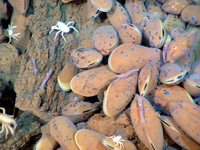
Galatheid crabs and shrimp graze on bacterial filaments on the mussel shells. The black "scars: on the shells are former anchor points of mussels who have cut their threads and moved on. Image courtesy of NOAA Submarine Ring of Fire 2004 (Volcanoes Unit MTMNM)
Taken April 9, 2004
CC BY-NC 2.0
https://flic.kr/p/bq6SWy


National Monuments in Danger


To comment on the marine monument and sanctuary review process 
(Due August 14, 2017):
https://www.regulations.gov/document?D=NOAA-NOS-2017-0066-0001


The comments period on the marine monuments has been extended until August 14, 2017. Along with the five Marine National Monuments we've looked at so far, there are also a number of National Marine Sanctuaries in danger of area reduction.

These marine parks were put into jeopardy through a second Executive Order signed by President Trump on April 28, 2017, which calls for the Secretary of Commerce to "review National Marine Sanctuaries and Marine National Monuments designated or expanded since April 28, 2007."

For the National Marine Sanctuaries and for Papahānaumokuākea Marine National Monument, "the area of the original designations" are not under review, "only their respective expansion areas completed in the past 10 years."

After Brent Rose's video on the Marianas Trench Marine National Monument, I'll post the list of sites affected by E. O. 13795.


National Marine Sanctuaries and Marine National Monuments Under Review Pursuant to EO 13795, Sec. 4(b)

Name
Location
Action
Date
Size in acres
Channel Islands National Marine Sanctuary
California
Expansion
May 24, 2007
9,600
Cordell Bank National Marine Sanctuary
California
Expansion
March 12, 2015
484,480
Greater Farallones National Marine Sanctuary
California
Expansion
March 12, 2015
1,288,320
Marianas Trench Marine National Monument
Commonwealth of the Northern Mariana Islands/Pacific Ocean
Designation
January 6, 2009
60,938,240
Monterey Bay National Marine Sanctuary
California
Expansion
November 20, 2008
496,000
National Marine Sanctuary of American Samoa
American Samoa
Expansion
July 26, 2012
8,691,840
Northeast Canyons and Seamounts Marine National Monument
Atlantic Ocean
Designation
September 15, 2016
3,114,320
Pacific Remote Islands Marine National Monument
Pacific Ocean
Designation; Expansion
January 6, 2009; September 25, 2014
55,608,320
Papahānaumokuākea Marine National Monument
Hawaii
Expansion
August 26, 2016
283,379,840
Rose Atoll Marine National Monument (1)
American Samoa
Designation
January 6, 2009
8,608,640
Thunder Bay National Marine Sanctuary
Michigan
Expansion
September 5, 2014
2,465,280

(1) All of Rose Atoll Marine National Monument is contained within National Marine Sanctuary of American Samoa.


To comment on the marine monument and sanctuary review process 
(July 31 - August 14, 2017):
https://www.regulations.gov/document?D=NOAA-NOS-2017-0066-0001


Marianas Trench Marine National Monument Map (as of July 2017) - JPG


Links


A Long Run to the Far Side (And Bottom) of the World (July 9, 2017)

Facebook


U. S. Senate: 

Peters, Colleagues Raise Concerns over Trump Administration’s Possible Rollback of 11 Marine Sanctuary and Monument Expansions (July 18, 2017)


National Marine Sanctuaries:

NOAA to reopen public comment period on review of national marine sanctuaries and marine national monuments (July 26, 2017)


Marianas Trench Marine National Monument:

USFWS Website
https://www.fws.gov/refuge/mariana_trench_marine_national_monument


The White House:

Proclamation 8335 -- Establishment of the Marianas Trench Marine National Monument
http://www.fpir.noaa.gov/Library/MNM/Proclamation%208335%20-%20Marianas%20Trench.pdf


Sunday, July 09, 2017

Marianas Trench Marine National Monument: A Long Run to the Far Side (And Bottom) of the World

A degassing event at Brimstone Pit
A degassing event at Brimstone Pit at NW Rota-1 volcano releases an extraordinary number of bubbles, probably carbon dioxide. The yellow parts of the plume (seen here in the background) contain tiny droplets of molten sulfur. Image courtesy of NOAA Submarine Ring of Fire 2006 (Volcanoes Unit MTMNM)
Taken on April 27, 2006
CC BY-NC 2.0
https://flic.kr/p/bD1Pht


National Monuments in Danger


We are down to the FINAL HOURS of the comment period!  Please, take the time today to comment on the fate of this national monument, any of the other 27 monuments on the Interior Department's list, or on the fate of all of them.  


To comment on the monument review process (due July 10, 2017):


Okay, really?  Our country is looking at getting rid of the Marianas Trench Marine National Monument?  This is just insane!

I mean, come on, it's the lowest point on the Earth.  It's the opposite of Mt. Everest!  And it's in United States' territory.  Not protecting this site is an insult to the world.

From the NOAA website

The Mariana Trench is the "Grand Canyon" of the ocean (actually 120 times larger), including some of the deepest known areas on earth. The region is geologically very complex, including a subduction zone, back arc basins, and active simmering island and submarine volcanoes. The active volcanoes and thermal vents support life under some of the harshest conditions on the planet. Maug Crater represents one of only a few places on Earth where photosynthetic and chemosynthetic communities of life are known to coexist. The waters of the archipelago's northern islands are also among the most biologically diverse in the Western Pacific. The greatest diversity of seamount and hydrothermal vent life yet discovered was found in the Marianas Trench.


For me, this post is a bit of a milestone.  I made it to the goal of posting at least once on every one of the 27 monuments in danger.  Of course, I wish I could have done much more, written much more about each of these places, and I am sure that I will have the opportunity to do so next week, too.

Even after the comments period closes, we can still be active, writing our politicians and other stakeholders to continue the fight.

Because I fear that, regardless of the incredibly positive input received by the Department of the Interior, and regardless of Secretary Ryan Zinke's final recomendations, that President Trump may just eliminate all or most of these places, anyway.

And there are disturbing signs...  But for today, for right now, the best thing to do is to leave some comments by following the links on this page and many others...

Not to beat a dead horse (just dying national monuments), We are down to the FINAL HOURS of the comment period!

Please, take the time today to comment on the fate of this national monument, any of the other 27 monuments on the Interior Department's list, or on the fate of all of them.

To comment on the monument review process (due July 10, 2017):
https://www.regulations.gov/comment?D=DOI-2017-0002-0001


Grazers


From National Geographic:


The monument, established in 2009, protects the deepest known points of the ocean as well as active undersea volcanoes and hot springs.


On the summit of East Diamante


From the USFWS Website:

On January 6, 2009, President George W. Bush established the Marianas Trench Marine National Monument by Presidential Proclamation under the authority of the Antiquities Act of 1906. The monument incorporates approximately 95,216 square miles within three units in the Mariana Archipelago. The Mariana Trench Unit is almost 1,100 miles long and 44 miles wide and includes only the submerged lands. The Volcanic Unit consists of small circles (2.3 miles in diameter) around 21 undersea mud volcanoes and thermal vents along the Mariana Arc, again only the submerged lands. The Islands Unit includes only the waters and submerged lands of the three northernmost Mariana Islands, Farallon de Pajaros or Uracas, Maug, and Asuncion, below the mean low water line.

On January 16, 2009, the Secretary of the Interior delegated his management responsibilities for the monument to the Fish and Wildlife Service through Secretary’s Order 3284. The Secretary’s Order also placed two of the units (the Mariana Trench and Volcanic Units) within the National Wildlife Refuge System as the Mariana Trench and Mariana Arc of Fire National WIldlife Refuges.


tubeworms


These videos are pretty amazing, and there are more available through the links below.  I could get lost for hours in these, but I need to keep on with some additional posts today.  Just because I've got all 27 monuments barely covered doesn't mean that there isn't a ton more content to add, and I think tomorrow's deadline will only mean a phase change in the process, not the end.

Stay tuned for more updates on how to save our monuments!


NOAA: Earth-Oceans Interaction Program (YouTube)

Marianas Expeditions 2014 - Present
https://www.youtube.com/channel/UCwYal-KFaA52F5lF9IUd9oA/playlists?view=50&sort=dd&shelf_id=13

Marianas Expeditions 2004 - 2010
https://www.youtube.com/channel/UCwYal-KFaA52F5lF9IUd9oA


Marianas Trench Marine National Monument Map (as of July 2017) - JPG

To comment on the monument review process (due July 10, 2017):


Links


Rubble - National Monuments in Danger:

Marianas Trench Marine National Monument

Facebook


Marianas Trench Marine National Monument:

USFWS Website
https://www.fws.gov/refuge/mariana_trench_marine_national_monument


The White House:

Proclamation 8335 -- Establishment of the Marianas Trench Marine National Monument
http://www.fpir.noaa.gov/Library/MNM/Proclamation%208335%20-%20Marianas%20Trench.pdf


Rose Atoll Marine National Monument: 27 Monuments "Stop" #23

Rose Atoll Marine National Monument and National Wildlife Refuge
Photo credit: Ian Shive/USFWS, March 22, 2016


National Monuments in Danger


We are down to the final days of the comment period!  Please, take the time today to comment on the fate of this national monument, any of the other 27 monuments on the Interior Department's list, or on the fate of all of them.  


To comment on the monument review process (due July 10, 2017):


The Rose Atoll is the furthest point south in the United States.  In some ways, that feels worthy of monument all on its own, but the real treasure here is the reefs.  As the National Geographic article I share with each one of these monuments explains, rising sea temperatures, pollution, and other factors are putting the world's coral reefs in extreme jeopardy.

Losing these reefs will do more than just bum out snorkelers and SCUBA divers, it might also bum out anyone who likes seafood, and anyone who depends on healthy oceans for anything (including all of us who like to breathe oxygen).  When the reefs go, it could lead affect much of the oceans in ways we are only beginning to understand...

So there is a lot at stake here and only HOURS left to make a comment!  Please do that TODAY, right now even!  Before it is too late...


Rose Atoll Marine National Monument and National Wildlife Refuge
Photo credit: Ian Shive/USFWS, March 23, 2016
CC BY-NC 2.0
https://flic.kr/p/U3a1Vd


From National Geographic:

Seabirds and turtles nest on this small atoll, one of the most pristine in the world at the southernmost point of the U.S. This thriving ecosystem is home to 272 species of reef fish, as well as many larger predators like whitetip and blacktip reef shark


Photo credit: Ian Shive/USFWS


Rose Atoll Marine National Monument Map (as of July 2017) - JPG

To comment on the monument review process (due July 10, 2017):


Links


Rubble - National Monuments in Danger:

Rose Atoll Marine National Monument

Facebook


Rose Atoll Marine National Monument:

USFWS Website
https://www.fws.gov/refuge/rose_atoll_marine_national_monument

https://www.flickr.com/photos/usfwspacific/sets/72157653913138348/with/34181849501/


The White House: