I've been buried in video work, both shooting and editing, since my last, true "photo of the day" post, but I wanted to take a few minutes to sneak one in today. No time for much writing, so here's a quick waterfall shot. Until next time...
I realized that a lot of folks might not know what these "photos of the day" posts are all about for me. Essentially, my rules, set by myself, for myself, are to post a previously unedited, unreleased photo as often as possible (every work day is a goal, though possibly one that is unobtainable at this point) and to try to write a line or two, at least, relating to the photo (usually), as well...
As for frequency, I want to keep this rolling, so I am not holding myself to posting each and every day, lest I get discouraged and decide that I am just too busy at this time to continue with this "project," and recently it seems like posts are the exception, not the rule, but I stumble along anyway... I've abandoned this project for long periods in the past for that very reason and I don't want to do that again right now.
This all really started back in 2011 as a way for me to force myself to work on photography every day. I was much better about posting most days back then, but as other ventures picked up, and as family life went through a busy and complicated few years, I set the project aside for a couple years.
It was feeling like a burden, and I felt like I'd accomplished most of the goals I'd set for myself with the project, which at the time involved working every day on digital photography (most of my serious work before was done with black and white film in these places called "darkrooms," not on computers), and to establish myself somewhat as a photographer.
The same rules applied back then, posting a previously unedited, unreleased photo, but without the writing component which is a new addition to the 2015 incarnation of this project...
Aside from feeling I'd met a lot of my goals back in 2012, and general busyness in other departments, another big reason why I abandoned the project for awhile was that I found myself rushing the work too much, and that I was not taking the time to select great photos (ones I love, at least) and that I was rushing the edit on them.
So, rather than flooding everyone with sub-par work, I thought it was best to pull the plug on the endeavour for a while.
Earlier this year, though, I realized that I was spending a tiny percentage of my time working on photography outside of the stills for the Recreating the HCRH project, which tend to be more survey oriented rather than artistic, by nature, and I felt that I needed to start forcing myself to spend some time working on my still photography again. Plus, I had several years of photos sitting on my hard drive collecting many layers of digital dust, and it seemed as though those shots might never make it out into the world without returning at least some of my focus back towards still photography.
Back in January, at the dawn of 2015, I tried to relaunch this project. I really only made it a few days, though, before the video work piled up and I found myself feeling like it just wasn't the right time to re-launch the POTD. But the photos were still piling up, and the work on photography still wasn't happening...
A couple months ago, though, I started feeling almost caught up, so I tried again, this time changing the expectations on myself away from rigidly posting every day to posting as much as possible, and that is where we are now. I post if I have time and I find a photo I like. I skip it if nothing is speaking to me or if I just do not have time. This should keep the quality somewhat decent (no guarantees... My taste, not yours! And sometimes I do post photos that have more sentimental value than artistic value, but then it will be explained in the written part of the post), and it lessens the risk of me abandoning the project all together due to feeling like I don't have the time to put the proper effort in.
Because of that, sometimes it will truly be the photo of the day, sometimes the photo of the week, sometimes the photo of the every once in awhile, but by giving myself the flexibility to post like that, hopefully I will posting more than a handful of shots every year. I am still calling it the "Photo of the Day," but it might not happen every day. It seems the right name for a project like this and I do hope to be consistently posting more than once a week, so...
For today's photo, I am revisiting the icy winter of 2012 / 2013... There was not much snow, really, but there was a lot of ice around the Gorge's falls, and they were spectacular. I've got a few of Multnomah that have never been posted from this trip that will emerge at some point, but I decided to post one up from Latourell. I've put a few of the shots from day at Latourell out before, but I was never happy with the edits. Who knows? I may hate this one too, on later review, but I wanted to take another swing at getting a photo that I liked out into the world from this set.
That is it for today. I'll be back tomorrow, or next week, or in a couple weeks... But, because of the new approach to this, I am, at a minimum, confident that I'll be posting again, sooner rather than later.
Back on it after being super busy preparing some film festival submissions and fighting the worst cold I've had in years... Not much time left for anything else between the two!
Just a plain old waterfall shot of Oneonta Falls from last summer. I'd love to get back there when that thing was really going, but I have no idea how to do that safely! Makes me cold just thinking about it...
Photo of the Day by A. F. Litt: October 20, 2015 Been too busy, then too sick, then too busy, then sick again to post. Getting back on it today... This was just a quick shot taken while out touring around with my sister and her husband while they were visiting our state. Not the greatest time of day to shoot this location, but we were out doing the sightseeing thing, not the photography thing, and I like it for what it is.
Sorting through some older photos from the Columbia River Gorge for my documentary on the Historic Columbia River Highway (www.RecreatingTheHCRH.org), I ran across this shot and thought it was an interesting one... It's a little amazing that even back in a ravine like this, the wind can be strong enough to blow a falls of this size as much as it does.
It's been awhile since I've posted a photo of the day, but I took this one while out working on www.RecreatingTheHCRH.org and really liked it, for what it is...
Well, it’s a new year and it’s time to start up the POTD again. I could discuss plans for the year, plans for the POTD project, plans for the Recreating the Historic Columbia River Highway project, plans for photography and filmmaking, plans for my family… All swirling through my head.
But it is a new year and who knows what God will bring us, so instead, a nice picture from the frozen Gorge yesterday.
Time to watch some football. There will be more time for all of this other stuff later.
On our second full day in Yellowstone, our afternoon was rained out, but not before we headed north from the campground to check out Tower Fall. I am used to waterfalls being named in the plural, “falls,” but the official name here, designated by the U. S. Geological Survey in 1928, is Tower Fall. It is the second most popular waterfall in the park, after Lower Falls, but I am not really sure what that means.
Now, honestly, since I pretty much live in the Columbia River Gorge, my family and I are getting almost obnoxiously jaded about waterfalls. Lower Falls, arguably, is one of the most spectacular waterfalls in the world, and yes, that one impressed us, but this one is, well… It is a very nice waterfall with some interesting pinnacles, old fossilized fumaroles, thrusting up above it.
But let’s face it- we didn’t go to Yellowstone to look at waterfalls!
Due to getting our reservations rather late, we needed to relocate for the third night, so we jammed down to Lewis Lake to grab a spot. Unfortunately, the afternoon thunderstorms we dealt with for most of the trip decided to camp down there as well.
Being good Oregonians, we busted out the tarps and books and settled in for a restful afternoon, though it did set our schedule back a bit later on, leading to a long catch up run late into the evening a couple days later, racing across the country trying to keep caught up with our reservations.
The North Rim of the Grand Canyon of the Yellowstone was our first stop in the park since we were camping at the Canyon Campground. It was morning and not too crazy busy yet, but still 17 people got this same shot from the same location in the 10 minutes we were there…
This brings up an issue I’ve struggled with on these types of shots, in these types of locations…
The scene is magnificent, the locations from which to shoot are limited, everyone there is taking the same picture, and even a quick look at Google Earth reveals that hundreds and thousands of people are taking essentially the same picture every year, every day even!
So, as a photographer, do you try to go for some crazy, unique angle or just stick with the basic, classic shot? Every day the weather and conditions are different, every few minutes the light changes the scene in subtle ways… We’re really not taking the same pictures over and over and over again, there are minute variations in style, technique and subject, sure, but how many untrained eyes are ever really going to be able to tell the difference?
Another complication in these locations is an issue of basic courtesy. In tourist mode, I am not comfortable setting up in the prime spot for even five minutes, planning out my shot, setting up my stabilization, taking test shots, taking real shots… all the while a line of people is forming up behind me until they are beating me over the head with their dSLRs, point-and-shoots, and smart phone cameras until I cede the position and let them in. I am trying to get in and out, showing basic courtesy to my fellow humans, and trying to be out of the spot in less than a minute. Sure, if I was coordinating with the NPS on the shoot, if I was on location in some sort of official capacity, I could take all the time I needed, but that is a different story entirely… Then I’d have access to different locations, which is my usual solution to these dilemmas, so the whole issue would resolve itself.
Living next to the Columbia River Gorge, I have to deal with this issue all most every week. Do I go for the classic shots, or do I go for the “creative” shots? For now, more often then not, I am choosing the classic shots. These are spectacular places and I like to let them speak for themselves.
Later, on my 20th visit to the same locations, by then I am branching out more and reaching for the more creative compositions, positions, and angles, but this is after I’ve got my sharp shot of Multnomah Falls, my slow shot, my icy shot, my summer shot, my fall shot, my long classic shot, my close classic shot, a great landscape orientation on each, a great portrait orientation on each… Then, if I am working for different clients on different projects, then I need to go get a new classic shot like this, a new classic shot like that… Suddenly, all those classic shots are adding up to a lot of work over many different seasons, over several different years. And these are the “classic shot” variations of just one subject in just one location… So how standard and redundant, really, is this basic, classic shot in the first place?
When I was younger, I was more focused on getting the “fancy” shots in these sorts of locations, the unique shots, but quite often I spent so much time trying to force my own small portion of creativity upon some amazing work of God and Nature that, just in its own existence, so far transcends the greatest artistic notions of even the most talented of men, that I ended up not getting the basic shots at all, the ones that succeeded in getting me out of the way and allowing the story of the place to tell itself.
And when dealing with some of the most photographed locations in the world, up to thousands of pictures a day for well over a hundred years, am I really going to come up with that one in a million shot that has never been taken before, one that brings a whole new perspective on the location or am I going to get something that feels a little forced, like I am trying a little too hard to be unique, and walking away with something that ends up not telling the story of the place at all?
There is a balance to all of this, of course. Sometimes those more unique shots just scream out to be taken, and I shoot them. Still, this summer, in tourist mode, not pro photo mode, for the most part I stuck to the basics. Because if I want to hang a great classic shot of the Lower Falls of the Yellowstone on my wall, I’d rather it be one I took, not one someone else took, and to me, that pretty much resolves the debate. At least, it does for myself. I am not going to be back in these locations for quite some time, if ever, and I want to make sure that I am capturing the spectacular beauty of these places and not just trying to prove to myself that I am a unique, out of the box, creative talent.
Sometimes art happens only when you are pushing the envelope, but at other times, it requires us pulling back a bit and letting the scene speak for itself. With some of these places, nature is trying to tell us a story, to show us something, and the reason we see the same shots over and over again is because this is what nature wants us to see over and over again, and I personally do not have a problem with that.
Acoustics can be strange, and the landscape, when seen from different angles, deceptive. Points reached by different routes can be confusing…
Lindsey Creek has two waterfalls for sure, Harrison Falls, actually visible from I-84 when the leaves are down in the winter, if you know where to look, and Lindsey Creek Falls.
But I am not entirely sure that these are the only two.
The lower waterfall is sometimes called Lower Lindsey Creek Fall, but more and more it’s old name is returning to use, Harrison Falls.
... This waterfall [Lindsey Creek Falls] was called Harrison Falls early in the 20th century. After the original Columbia River Scenic Highway was built, a number of auto camps were built along the new road. The one that operated at Lindsey Creek was known as Harrison's Auto Camp. No trace of it remains.
... Early postcards have this waterfall captioned as "Harrison Falls", or "Harrison Falls near Harrison Auto Camp, Columbia River Highway". I suspect this is simply a historic unofficial naming. ...Harrison Falls is the Historical name of this waterfall. Known Alternate Names: Lower Lindsey Creek Falls.
Columbia Gorge Discovery Center Photo Archive Catalog Num: 1999.13.94P Condition: Good Date: Location: The Dalles, Oregon Title: Content: No. 52. Harrison's Auto Camp, Columbia River Highway Other Notes: description from above on front.no correspondence Photographer: B.C. Markham, The Dalles, Oregon Copyright: http://www.gorgediscovery.org/photoarchive/newDetails.asp?offset=970&ID=2695
Today, nothing remains of the scene pictured above. Decades of flooding have wiped out not only the site of this camp but also the picnic area that was near Lindsey Creek until the 1960s.
There is a sort of trail to the falls leading up the east bank of the creek, though it may require getting wet here and there (in November, at least, when I was there last). Good views can also be found on the slopes above the west bank, at least when the leaves are down. This is where I shot my photo of these falls from.
Still, looking at the map above, it seems like Harrison Falls may be marked a little too far upstream. Standing on the west side of the ravine above, though, under the powerlines, one can hear Harrison Falls towards the freeway, but it sounds like there is another large waterfall upstream from it to the south, best heard from the south edge of the powerline clearing.
Above a waterfall? Sure sounds like it, but it is tricky and dangerous getting much closer than this. Upstream from Harrison Falls so I think this is a different one. There is a third further to the south, but I suspect this is the big one on Lindsey Creek, it's quite a drop between the valley on the right and the ravine on the left. Columbia River Gorge National Scenic Area. Oregon. November 1, 2013.
Not quite sure what is down there, and at first I thought it was the waterfall Scott Cook calls Lindsey Creek Falls in his book Pokin’ Round The Gorge, but reading the directions to that waterfall a little more closely, and then tracing them out on Google Earth, this is starting to sound more like the one marked on the map above and one I’ve glimpsed from the Lindsey Creek Road, which is marked in blue on the map below.
Follow the double track to the last tower, cut left around it then swing to the right, under the lines and over the sticks into the forest. Pick your way on the old roadbed for a minute until you see a rough trail climbing down to the left. Follow this down then angle upstream and bushwhack over to the creek … and take note of where you are so you can find it on the way back! Now you begin to splash, bob, weave and hop for 8-9 minutes to the falls.
Scott Cook. Pokin’ Round the Gorge. Hood River, OR: Scott Cook. 2008. 81.
Roughly recreating his directions in Google Earth leads to a map that looks like this, though in November 2013, few traces of the roads Cook describes were visible. The route below is speculative, so please use caution if attempting to follow it, and it is based on a combination of Cook’s directions and my own experience in the area.
His photo of the falls themselves graces the cover of the book. There are more inside, but due to the nature of that book, and this site, this is the only one I’m comfortable posting!
So, is there a hidden “Middle” Lindsey Creek Falls? There could be. Cook’s directions to the upper falls seems to bypass the area where the sound of a waterfall is coming from. Also, zooming in a bit on Google Earth, there sure seems to be at least one waterfall down there that looks at least as large as Harrison Falls.
Click to enlarge…
One of these days I’ll pick my way down into that ravine and find out, unfortunately, the last time I was there I was by myself, it was getting late, and nobody really knew where I was if something went wrong, so I was playing it really safe and taking no risks. But I think this summer, tramping up and down the creek on a hot summer day may be a fun adventure!
I’ll update with what I find!
Update – Like 15 minutes later…
I need to remember to hit Google before I hit send…
A good thread (with great pictures) on Lindsey Creek. Probably not a big “middle” falls in there, just lots of whitewater essentially making the whole stretch one big falls. But there are more falls upstream from Lindsey Creek Falls.
I spent a lot of time when I was younger in this area outside of North Bend, Washington. The last couple years, I got to revisit the area and it has changed a lot. New campground and day use facilities, etc… Some of the old roads are closed, which I don’t like, but if it helps to preserve the area, I suppose that is for the best.
When my dad and I first went out there in our big, old orange pick up truck, I was amazed that a place like this existed only minutes from our home in Issaquah. I remember saying, “I can’t believe this isn’t a National Park. It’s almost like Yosemite out there.”
Well, I had never been to Yosemite at that point, I have since, and while the Middle Fork is pretty spectacular, it might not quite be Yosemite spectacular, though for being, like I said, a few minutes from home, it was pretty damn good.
I suppose I am not the only one who felt that way. This year, I found these quotes about the area…
This is from a development plan for the area from the mid-1990s and describes the area as I knew it as a teenager…
The Middle Fork Valley is one of the more significant, close-to-home places in King County. Often called the “Yosemite of the Cascades,” the Valley is less than one hour drive from over one million people within the Seattle metropolitan area. As a destination, the Valley presents a beautiful, yet mysterious, challenge. There is no managed entry into the Valley, no centrally located orientation point that offers watershed-wide interpretive or wayfinding information, and no wayside exhibits, markers or developed interpretive facilities. (9)
Before our trip out there this summer, looking for trails, I saw another quote that I couldn’t find today mentioning that, if this area was located this close to pretty much any other city than Seattle, it probably would have been a major National Park. However, since Seattle is so spoiled with natural wonderlands in such close proximity, that this area has pretty much been overlooked by everyone.
When my dad and I first stumbled into this valley back in the 1980s, this is what surprised me the most. How nobody seemed to know about it. Well, not the right people, at least. We found it on our Mt. Baker-Snoqualmie National Forest map, a long, long road leading way back into the mountains, and decided to go check it out.
The development report describes the drive as it was back then. The road is a little better maintained these days, but this still pretty much describes the drive today.
It takes approximately 30 minutes to drive the Middle Fork River Road from the mouth of the Valley to Taylor River. The road is narrow, rough and windy in places, requiring attentive, slow driving. But the focus is well rewarded. As one enters the Valley, time slows and a quiet forest of trees encloses the roadway. Ferns, logs and moss thicken the wet forest floor. And the rushing of the River can be heard clearly through the trees.
As one moves upstream, the forest canopy opens and closes. One catches only glimpses of lonely peaks, ridges, and the River. Finally, at the Middle Fork bridge, views up and down the River’s meanders reveal the full, u-shaped figure of the Valley from Bessemer Mountain to Russian Butte.
Beyond the Middle Fork bridge, the rough road leads deeper up the Valley. It widens and straightens but closes under trees as it moves nearer the River. Now, the Middle Fork is ever present, separated from the road at times only by wetlands and small streams tumbling off of the Valley’s west ridges. Muddy vehicle tracks and narrow spurs leading to the river’s edge are numerous. As the road finally reaches Taylor River, the landscape opens on to young forest and giant old trees, the joining of the Taylor and Middle Fork, and the looming cliffs of Garfield Mountain. (25)
Through the late 1980s and early 1990s, it was pretty “Wild West” out there. Contrary to my first impressions, a lot of people, apparently, knew about the area… The road back there was always busy, but it could be a fairly rough crowd. In fact, later in High School, almost every one I knew learned about the Middle Fork, since this is where most of the major keggers occured, out at Taylor River, as everyone called it.
Again, from the 1990s development report:
Some hiking and boot-built trails, (many familiar to only the most intrepid of hikers), used and unused logging and spur roads, and a single main road carry recreationists to high elevation trails and to backcountry and wilderness destinations. Meanwhile, many visitors experience the river corridor in glimpses from the road. They stop for short visits at locations where the river is visually or physically accessible and shorelands appear safe and unlittered, or at pullouts where parking looks relatively hazard-free. Many of the sites provide excellent river views and relatively easy river access, but some are poorly located and visitor use has resulted in significant stream-side erosion and vegetation damage. All are usually littered with garbage or human waste. Given these conditions, visitors do not generally experience a positive or comprehensive sense of the river or the larger Valley. (9)
Things got even worse, it seems, before they started getting better.
The Middle Fork Snoqualmie River valley has come a long way. Once the playground of loggers and miners, the valley was stripped of many of its resources and then left torn and tattered. Soon came the unsavory characters, making the Middle Fork their own personal dumping ground. Drug users and meth producers fouled the forest with their toxic concoctions. Then came the Middle Fork Coalition, a hard-working group of volunteers who helped the Forest Service clean up the valley while developing plans for its future greatness. Roads were closed, trails were built, garbage dumps were cleaned up. Peace and quiet was restored. Today, the Middle Fork Snoqualmie is a recreationist's dream, and the Middle Fork Trail is one of the best recreational resources in the valley.
Diving out there last year, I was amazed at the changes. Day use areas and a campground. Though, as I said, I was a little frustrated with the Dingford Creek gate. Once, dad and I made it all the way out to the end of the road below Dutch Miller Gap, and I remember that it was pretty spectacular out there. However, I also remember that the road was in pretty rough shape back then.
I don’t ever remember the Taylor River road being open beyond the bridge, but from what I was reading today, it apparently was open off and on for a while through the 1990s, at least. Of course, it is permanently gated now and the road is, rather dramatically, returning to nature.
We spent a couple nights in the forest service campground this summer. Not the first night I’d spent out there, but the first in a real campground. The first night we were there this August, as we were settling in for bed, I got up and locked the van.
The Ex One asked me if that was really necessary since there was only one other group in the entire campground that night (it was a weeknight, the weekend was booked full to capacity). I mumbled something about her not remembering that area like I did, and I locked up.
Apparently, more development is in the works. First up, paving the road out there. I have bitter sweet feeling about this. Yes, it would be nice to get in and out of the area a little quicker and with less washboards and pot holes bouncing us everywhere, but a paved road just means more people.
I suppose the valley isn’t much of a secret place anymore, and more people are inevitable. But I think that is what was fun about the area when I was young. It was a secret place. Of course, there were good things and bad things about that, but it was fun.
Now the Forest Service and King County have agreed to pave the stretch of the Middle Fork Snoqualmie Road (FR 56) from where the current pavement ends (MP 2.7) to the Middle Fork Campground (MP 12.4). A Memorandum of Agreement (MOA) between the Federal Highway Administration, King County Department of Transportation and the US Forest Service has been completed for $20 million the proposed project.
Camp Brown
Crashing around on the old roads out up the Middle Fork in our old orange pick-up, or later on with my little Blazer, we had a lot of fun driving up random spurs and looking for hidden places. Never found much except for the occasional washout and the joy of having to back a quarter mile down a steep and windy road to a place where we could turn around…
Well, today the roads are gated. But we do have the internet, so instead of spending long afternoons poking around for secret places and crumbling history, we can actually just look them up and head out directly to them.
There is a lot of history out there. This was obvious back in the day, but before the internet it was hard to find out much about it. All the woods east of Seattle have a nearly haunted feeling from their heavy use over the years. Logging, mining, etc...
The area I grew up in felt like this. You could sense the ghosts of times long past wandering through the second and third growth forests.
Those woods are now long gone, mowed down one final time and replaced by endless housing developments. But the Middle Fork woods remain, and they too are filled with artifacts and ghostly reminders of a nearly forgotten past.
Working on these pictures earlier, I became curious about the Camp Brown mentioned on this old road sign, miles up a trail now near what used to be the terminus of the Taylor River Road…
Apparently, this might be a pretty old sign… Here are some mentions of Camp Brown:
In 1937 the NBTC abandoned Camp Brown and started to pull the main rail line. The CCC road was built in 1938 and extended to Goldmeyer Hotsprings in 1939. In 1941 the NBTC indicated the intention to stop railroad logging and the rail lines were pulled out in 1942 (it seems highly unlikely according to the most reliable sources that the rails were sold to pre-war Japan as some rumors have indicated). In 1942 the rail line was converted to a truck road.
Yesterday, Schrenk and Johnson pointed out one area along the Middle Fork road where a former logging camp called Camp Brown has been transformed into a deep-rutted, mud-holed obstacle course -- with trees as the obstacles. The practice of driving rigs around in the mud -- or in some cases, the river itself -- is called "mudding.”
Backpacker Joe:There are a few small remains. In the old days when I/we/you had to ford the creek there I remember a could old wooden artifacts. Now that you can walk across the bridge you might head up there a take a look.
...
"1928-29 Railroad extended to 1 mile past Taylor River. Camp Brown is built (named after Robert Brown, civil engineer for laying track on the Middle Fork railroad who was run over and killed by a backing locomotive in 1928)."
mtnresqr: From what I remember as a kid, Camp Brown was a USFS Guard Station alongside Middle Fork road. Like around late 1950's. A small Ranger Station in a wooden cabin. Then the log cabin got rickety or damaged and was torn down. The USFS put a concrete pad down, to park a small camping trailer, for a seasonal USFS place. Maybe around early 1960's.
And, back before that, over on Rainy Creek, on other side of MF river, there was a water works, that provided water for the camp, thru some 7-8 inch wooden water pipe. the remains of that pipe still shows in a few places, by the wire wrapping remaining. Like continuous coils of wire that was used to wrap the wooden pieces to hold it into a pipe. On the far side of Rainy Creek, near the new bridge on the new Pratt Connector trail. That is because in the past, Camp Brown was a fairly large timber company logging camp. Must have had a water pipe system across Middle Fork River.
The location of the concrete pad, is at the wide spot on MF road about three fourths mile before the Middle Fork Trail Head parking lot. This 'wide spot' gets used as a once popular camping spot in Summer. Park cars and wander out an old road to river.
lopper: There was a "single-wide" prefab trailer on the slab until the mid 1970's. It was always locked and un-manned during my comings and goings 1968-1974.
Also there was a wall-sized wooden sign-board on the east side of the parking area next to the trailer. I think that the sign listed distances to the main road-accessed trailheads further up the roads east and north. I wonder if anyone has a picture of that sign? It was big....like the one at US10/Denny Creek in the old days.
South of the Guard Station, at the riverside (in the mid 1970s), there was a large stump wrapped with steel cables where a footbridge had once crossed the MFK to the Rainy Cr. Trail. (not to be confused with the wire bridge at the Pratt confluence).
When I worked for the USFS in Wenatchee in 1978, I had a supervisor who had been stationed at Camp Brown for a couple of summers in the late 1950s or early 1960s.
…
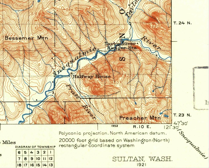
Here is more grist for the Camp Brown discussion mill. See 1921 USGS map below.
"Halfway House" at the Pratt Confluence. Halfway to where? North Bend to Goldmyer?
"Taylor River Ranger Station" Located across the MFK from where the future Taylor River Campground (1950s-70s) would be.
Pre-CCC, the only land route up alongside the MFK is on the south bank.
Camp Brown is located approximately one mile south of Taylor River on the Middle Fork at River Mile 64. It is located in the Bessemer Mt. Place with views into the Rainy Creek Place. The site is proposed to augment facilities at Taylor River by providing additional car parking, river access and a trail connection. (94)
The map, above, is old and depicts the suggested plans, not the reality, but it accurately zeros in on Camp Brown’s location. I have no idea what is actually where now, if there is anything to see at all.
If I end up that way again next summer (pretty likely), it will be on my list of places to check out.
I, also, know nothing about the “Taylor River Campground (1950s-70s)” and the old ranger station mentioned above. More old sites to check out? Further research is required.
Here is the 1960 USGS map of the area…
For more information on the history of the Middle Fork, this is a pretty cool site:
Quotes in the title because, as you can see, there isn’t much of a trail. Just a climb over the log jam and a wade up the creek through the narrow canyon to the waterfall.
This was my first time heading out there. I’d heard that the water in “the deep part” was about six feet deep, but after the dry summer, it was only about three and a half feet. But cold!
It was also pretty busy with the traffic jam through the log jam requiring a little patience to traverse the obstacles in a safe manner.
I didn’t take my good camera with me, fearing it would get wet, and most of the pictures I took were shot using my son’s waterproof video camera, so they are low res with an unusual aspect ratio. However, the long aspect ratio actually works pretty well in that environment.
Still, I would like to get some better shots out there and the water is low enough that I would not be too concerned about taking my best camera out there with me right now (mind you, my “best” camera is still relatively disposable). Though it’s a couple weeks later, it’s been dry enough that I doubt conditions have changes out there much, and the weather looks warm and dry for the rest of the week so I might sneak out there again later this week while the boys are in school. Probably not, but maybe…
Photo Above: A large group trying to avoid the cold water of the one deep pool. This was a pretty risk maneuver and more than one of them slid off the wet rocks into the water, getting quite a bit more soaked than they would have otherwise. My advice? Stay safe and just suck it up. It’s ain’t that cold! Besides, as you can see in the top photo, you can’t really avoid it anyway…
Seems precarious, but it shouldn't be.... thousands do it every year.... and they all survive. Almost immediately you will come to a large log jam stuck in the canyon. Be VERY CAREFUL when crossing this, especially if any of it is wet, because it can be very slippery. After you get across the log jam, now you just walk up the creek.... I mean wade.... in other words.... YOU GET WET. This is a very short hike, but very soon you are up to your you know what is water. Yes, it gets deep, and for children, they may not be the ticket, especially for small children. The water at its lowest is probably about 3 feet deep, so we aren't talking over anyone's head.... unless anyone is very short.
More recently, this tradition has been tarnished by a series of natural events that have made the trip up Oneonta Gorge downright dangerous. First, a rockfall near the entrance to the Gorge in the late 1990s that left three pickup-sized boulders in the stream. Then a logjam formed behind the boulders, creating a slippery maze that hundreds of visitors each summer now struggle to navigate. Sadly, the danger prevents many families with children from even attempting the trip.