
 |
| Photo: Bob Wick, BLM California Taken on August 20, 2009 CC BY 2.0 https://www.flickr.com/photos/mypubliclands/8803445227/in/album-72157633622349991/ |
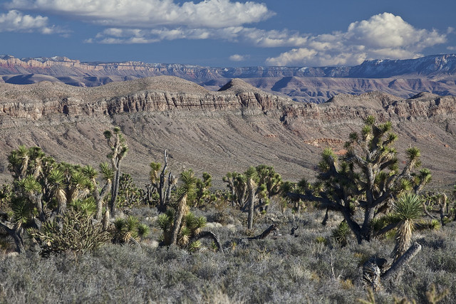
The first in a bit that Brent Rose hit that I haven't been to at all... Clearly, from his video, this is a rugged place, and the old van from last spring probably wouldn't have been up to the challenge! She did great in some sketchy situations, but there's only so much one can do with an old Kia Sedona.
This one is jointly managed by the Buearu of Land Managment (BLM) and the National Park Service (NPS). Hopefully it's remoteness can save it.
This one is jointly managed by the Buearu of Land Managment (BLM) and the National Park Service (NPS). Hopefully it's remoteness can save it.
According to Wikipedia:
The 1,048,325-acre (424,242 ha) monument is larger than the state of Rhode Island. The BLM portion of the monument consists of 808,747 acres (327,288 ha).[1] The NPS portion contains 208,453 acres (84,358 ha) of lands that were previously part of Lake Mead National Recreation Area. There are also about 23,205 acres (9,391 ha) of Arizona State Land Department lands and 7,920 acres (3,210 ha) of private lands within the monument boundaries.
Wikipedia also answers one of my biggest questions about the monument, "Parashant is derived from Paiute word Pawteh 'ee oasoasant, meaning 'tanned elk hide,' or 'softening of the elk hide.'"
The NPS is currently updating their official park map. The new version will be available in "late 2017."
The major safety update to the map below includes a change in roads to show most of the roads as high clearance/four-wheel drive strongly recommended. The current map indicates many of these roads as being regularly maintained but they are sometimes impassible because of flooding and washouts. Roads in the Parashant are not appropriate for cars because of low clearance and thin tires designed only for paved road use.
The map also shows water in Grand Wash Bay near Tassi. Grand Wash Bay has been dry for over 10 years. Lake Mead is at about 45% capacity and Grand Wash Bay will not have water for the foreseeable future. The new map will show the current water of Lake Mead correctly.
The monument also contains many archaeological sites, according to the Presidential Proclamation establishing the monument:
Archaeological evidence shows much human use of the area over the past centuries. Because of their remoteness and the lack of easy road access, the sites in this area have experienced relatively little vandalism. Their good condition distinguishes them from many prehistoric resources in other areas. Prehistoric use is documented by irreplaceable rock art images, quarries, villages, watchtowers, agricultural features, burial sites, caves, rockshelters, trails, and camps. Current evidence indicates that the monument was utilized by small numbers of hunter-gatherers during the Archaic Period (7000 B.C. to 300 B.C.). Population and utilization of the monument increased during the Ancestral Puebloan Period from the Basketmaker II Phase through the Pueblo II Phase (300 B.C. to 1150 A.D.), as evidenced by the presence of pit houses, habitation rooms, agricultural features, and pueblo structures. Population size decreased during the Pueblo III Phase (1150 A.D. to 1225 A.D.). Southern Paiute groups replaced the Pueblo groups and were occupying the monument at the time of Euro-American contact. Archeological sites in the monument include large concentrations of ancestral Puebloan (Anasazi or Hitsatsinom) villages, a large, intact Pueblo II village, numerous archaic period archeological sites, ancestral Puebloan sites, and Southern Paiute sites. The monument also contains areas of importance to existing Indian tribes.
Wikipedia also mentions that the monument contains 24 known caves. A 2005 study revealed these caves contain "two new species of millipede, the first barklouse discovered in North America, a whole new genus of cricket and four new cricket species."
BLM: Grand Canyon-Parashant National Monument (as of June 2017) - PDF
To comment on the monument review process (due July 10, 2017):
To comment on the monument review process (due July 10, 2017):
Links
27 Monuments:
Website
https://www.27monuments.org
Facebook
https://www.facebook.com/27Monuments
Instagram
https://www.instagram.com/brentdangerrose
https://www.instagram.com/explore/tags/27monuments
BLM:
Grand Canyon-Parashant National Monument Website
Grand Canyon-Parashant National Monument Map
flikr
https://www.flickr.com/photos/mypubliclands/sets/72157633622349991/
National Park Service:
Parashant National Monument
Park Map
https://www.blm.gov/nlcs_web/sites/style/medialib/blm/az/images/parashant.Par.10414.File.dat/proclamation.pdf
Wikipedia:
Grand Canyon-Parashant National Monument
https://en.wikipedia.org/wiki/Grand_Canyon-Parashant_National_Monument
No comments:
Post a Comment