Showing posts with label Nevada. Show all posts

Wednesday, June 28, 2017

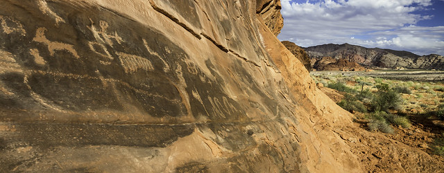
Basin and Range National Monument: Carl Leaves His Mark at 27 Monuments Stop #9

BLM Photo Bob Wick
Uploaded to flikr on September 21, 2015
CC by 2.0
https://flic.kr/p/yUEkCf


https://sites.google.com/view/nationalmonumentsindanger/home


Who is Carl?  Well, watch Brent Rose's video to meet the 1929 version of Carl.  Damnit, Carl!

To be fair, things were a bit different back then.  I discuss this a bit in an old post on Hickman Bridge at Capitol Reef National Park.

I have about this one last post before the battery dies!  More tomorrow...


Or not!  Life got busy the last few days in Seattle and now I am posting from the bus on the way home...  More on that in the next post!

Basin and Range National Monument


BLM: Basin and Range National Monument Map (as of June 2017) - PDF


To comment on the monument review process (due July 10, 2017):


Links


27 Monuments:

Website
https://www.27monuments.org

Facebook
https://www.facebook.com/27Monuments

Instagram
https://www.instagram.com/brentdangerrose
https://www.instagram.com/explore/tags/27monuments


BLM: 

Monday, June 26, 2017

Gold Butte National Monument: 27 Monuments Stop #8

Photo: BLM
Taken on September 28, 2016
CC BY 2.0
https://flic.kr/p/Q6VrNd


https://sites.google.com/view/nationalmonumentsindanger/home


In Seattle, today, the natural air conditioning kicked in, but it was 87 degrees here yesterday and 101 degrees back home in Portland. I am definitely envious of Brent Rose's trip, but 117? That's just crazy. He's taking one for the team!

I am racing with my laptop battery to get this post out before the computer dies and I need to re-locate.  Hopefully, I can get caught up with Rose's travels today, but if not, there is always tomorrow.

According to the Bureau of Land Management (BLM) website, this monument is named after an old "mining ghost town." It is located just across the Arizona-Nevada border from, and shares that border with, Grand Canyon-Parashant National Monument.


On their flikr photo, the BLM writes:

Gold Butte National Monument covers nearly 300,000 acres of remote and rugged desert landscape in southeastern Nevada, where dramatically chiseled red sandstone, twisting canyons, and tree-clad mountains punctuate desolate stretches of the Mojave Desert. The brightly hued sandstone provides a stunning canvas for the area’s famously beautiful rock art, and the desert provides critical habitat. The area is popular for outdoor recreation, and visitors to the monument can hike to rock art sites, drive the Gold Butte Backcountry Byway to the area’s namesake mining ghost town, hunt desert bighorn sheep, or tour the area’s peaks and canyons on horseback.

This was one of the last monuments proclaimed by President Obama, being designated on December 28, 2016.


Gold Butte National Monument, Nevada


BLM: Gold Butte National Monument (as of June 2017) - PDF


To comment on the monument review process (due July 10, 2017):


Links


27 Monuments:

Website
https://www.27monuments.org

Facebook
https://www.facebook.com/27Monuments

Instagram
https://www.instagram.com/brentdangerrose
https://www.instagram.com/explore/tags/27monuments


BLM: 

Tuesday, April 12, 2016

Amaragosa Valley, East of Death Valley

A. F. Litt: Nevada &emdash; Amaragosa Valley, East of Death Valley
Amaragosa Valley, East of Death Valley
Amaragosa Desert and the Grapevine Mountains.  Near Rhyolite, Nevada. March 31, 2016.
Copyright © 2016 A. F. Litt, All Rights Reserved

Photo of the Day by A. F. Litt: April 12, 2016

This is not that exciting of a picture, shot at speed while cruising down the highway, but I dug it out this morning while trying to dial in the location of the photo by Ghenadie Shatov in the Facebook post below.  I originally remembered this valley being even emptier than this, and was not sure that it taken where I thought it was...  But it was.  While not quite in the National Park itself,

My shot is not nearly as great as Shatov's shot, but this was taken a couple weeks ago... It's near the road to Rhyolite, just west of Beatty, outside the park to the east. So this is the Amaragosa Valley and the Grapevine Mountains, but not quite in the park yet, though it is not too far from the park entrance and the mountains are in the park itself....


Death Valley National Park, California. Photo by ©Ghenadie Shatov
Posted by Earth Porn on Thursday, January 21, 2016


Below are a couple of photos of the descent from Daylight Pass into Death Valley itself...

A. F. Litt: Death Valley National Park &emdash; Down into Death Valley
Down into Death Valley
Daylight Pass Road.  Death Valley National Park, California.  March 31, 2016.
Copyright © 2016 A. F. Litt, All Rights Reserved

A. F. Litt: Death Valley National Park &emdash; Intersection and Dunes in Death Valley
Intersection and Dunes in Death Valley
Daylight Pass Road.  Death Valley National Park, California.  March 31, 2016. 
Copyright © 2016 A. F. Litt, All Rights Reserved

And here are a few shot near the site of the first photo, outside of the park looking the other direction...

A. F. Litt: Nevada &emdash; Pronghorn, Rhyolite, and the Bullfrog Hills
Pronghorn, Rhyolite, and the Bullfrog Hills
Amaragosa Desert near Rhyolite, Nevada. March 31, 2016.
Copyright © 2016 A. F. Litt, All Rights Reserved

A. F. Litt: Nevada &emdash; Pronghorn in the Amaragosa Valley, East of Death Valley
Pronghorn in the Amaragosa Valley, East of Death Valley
Amaragosa Desert near Rhyolite, Nevada. March 31, 2016.
Copyright © 2016 A. F. Litt, All Rights Reserved

A. F. Litt: Nevada &emdash; Pronghorn Below Rhyolite
Pronghorn Below Rhyolite
Amaragosa Desert near Rhyolite, Nevada. March 31, 2016.
Copyright © 2016 A. F. Litt, All Rights Reserved