
 |
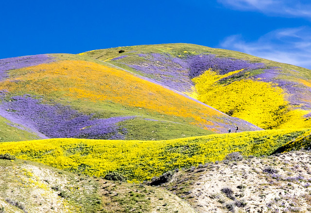
| Photo by Bob Wick, BLM Wilderness Specialist and Photographer Carrizo Plain National Monument. California. April 2, 2017. https://flic.kr/p/TjXSpT |
The best laid plans... I was hoping to visit this monument last year as a part of my December trip south, but life did not co-operate. No pictures of my own.
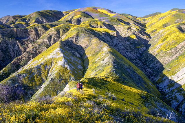 |
Photo by Bob Wick, BLM Wilderness Specialist and Photographer
Carrizo Plain National Monument. California. April 1, 2017.
https://flic.kr/p/TjXTgx |
This southern California monument, proclaimed by President Clinton on January 17, 2001, is one of the nearly 30 monuments currently at-risk of elimination by the Trump Administration.
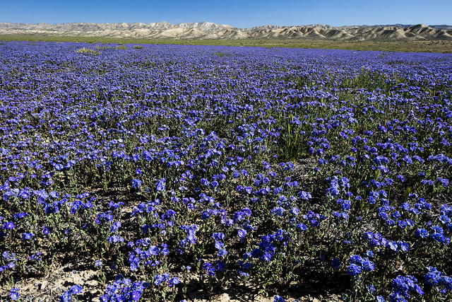 |
Photo by Bob Wick, BLM Wilderness Specialist and Photographer
Carrizo Plain National Monument. California. March 26, 2016.
|
Three hundred years ago, California’s Central Valley was vast grassland where antelope and elk grazed and wildflowers swept the spring landscape. Today, amid urban and agriculture development, a remnant remains in the Carrizo Plain National Monument.
Carrizo Plain National Monument is one of the best kept secrets in California. Only a few hours from Los Angeles, the Carrizo Plain offers visitors a rare chance to be alone with nature. Some visitors say you can "hear the silence." The plain is home to diverse communities of wildlife and plant species including several listed as threatened or endangered and is an area culturally important to Native Americans. This remote monument, traversed by the San Andreas Fault which has carved valleys, created and moved mountains, and yet up close, is seen in subtle alignment of ridges, ravines and normally dry ponds. Prominent features on the monument include the white alkali flats of Soda Lake, Painted Rock, vast open grasslands, and a broad plain rimmed by mountains. When conditions are right, numerous wildflowers can carpet the valley floor; although short lived it can be breathtaking.
Soda Lake, normally a dry lake bed, is one of the dominant geographic features of the Carrizo Plain. It is the largest remaining natural alkali wetland in southern California and the only closed basin within the coastal mountains. As its name suggests, Soda Lake concentrates salts as water evaporates, leaving white deposits of sulfates and carbonates that look like baking soda.
https://www.blm.gov/nlcs_web/sites/ca/st/en/prog/nlcs/Carrizo_Plain_NM.html
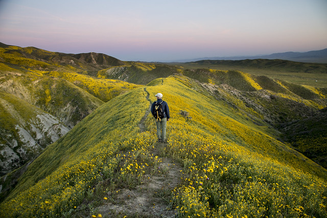 |
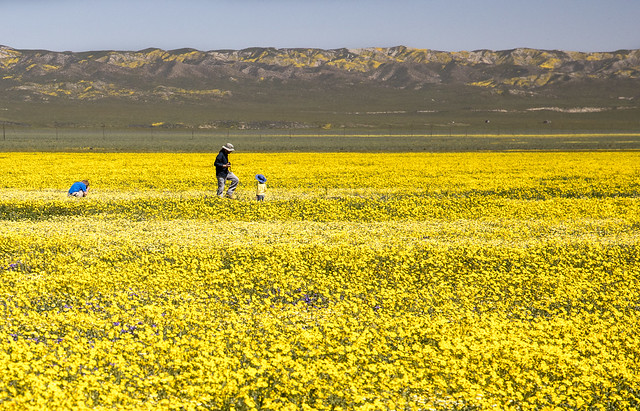
Photo by Bob Wick, BLM Wilderness Specialist and Photographer
Carrizo Plain National Monument. California. April 1, 2017.
https://flic.kr/p/TZMfNx |
"Healthy" rains this spring led to an "epic" wild flower bloom in southern California this spring, the Los Angeles Times reported in early April.
The super bloom has migrated north to California's Central Valley and the show is simply indescribable at the Carrizo Plain National Monument. The Valley floor has endless expanses of yellows and purples from coreopsis, tidy tips and phacelia, with smaller patches of dozens of other species. Not to be outdone, the Temblor Range is painted with swaths of orange, yellow and purple like something out of a storybook. I have never seen such a spectacular array of blooms. Ever.
Bob Wick: https://flic.kr/p/TjXSpT
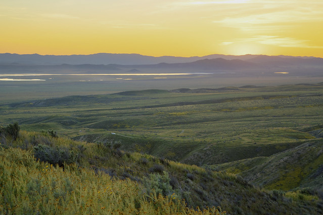 |
Photo by Bob Wick, BLM Wilderness Specialist and Photographer
Carrizo Plain National Monument. California. April 1, 2017.
https://flic.kr/p/TWcVA9 |
Check out the links below for some awesome photos from the 2017 "Super Bloom."
Preamble to the Presidential Proclamation Establishing Carrizo Plain National Monument:
Full of natural splendor and rich in human history, the majestic
grasslands and stark ridges in the Carrizo Plain National Monument
contain exceptional objects of scientific and historic interest. Since
the mid-1800s, large portions of the grasslands that once spanned the
entire four hundred mile expanse of California's nearby San Joaquin
Valley and other valleys in the vicinity have been eliminated by
extensive land conversion to agricultural, industrial, and urban land
uses. The Carrizo Plain National Monument, which is dramatically
bisected by the San Andreas Fault zone, is the largest undeveloped
remnant of this ecosystem, providing crucial habitat for the long-term
conservation of the many endemic plant and animal species that still
inhabit the area.
The monument offers a refuge for endangered, threatened, and rare
animal species such as the San Joaquin kit fox, the California condor,
the blunt-nosed leopard lizard, the giant kangaroo rat, the San Joaquin
antelope squirrel, the longhorn fairy shrimp, and the vernal pool fairy
shrimp. It supports important populations of pronghorn antelope and tule
elk. The area is also home to many rare and sensitive plant species,
including the California jewelflower, the Hoover's woolly-star, the SanJoaquin
woolly-threads, the pale-yellow layia, the forked fiddleneck,
the Carrizo peppergrass, the Lost Hills saltbush, the Temblor buckwheat,
the recurved larkspur, and the Munz's tidy-tips. Despite past human use,
the size, isolation, and relatively undeveloped nature of the area make
it ideal for long-term conservation of the dwindling flora and fauna
characteristic of the San Joaquin Valley region.
The Carrizo Plain National Monument also encompasses Soda Lake, the
largest remaining natural alkali wetland in southern California and the
only closed basin within the coastal mountains. As its name suggests,
Soda Lake concentrates salts as water is evaporated away, leaving white
deposits of sulfates and carbonates. Despite this harsh environment,
small plant and animal species are well adapted to the setting, which is
also important to migratory birds. During the winter months the lake
fills with water and teems with thousands of beautiful lesser sandhill
cranes, long-billed curlews, and mountain plovers.
The Carrizo Plain National Monument owes its existence to the
geologic processes that occur along the San Andreas Fault, where two of
the Earth's five great tectonic plates slide past one another, parallel
to the axis of the Plain. Shifting along the fault created the Plain by
rumpling the rocks to the northeast into the Temblor Range and isolating
the Plain from the rest of the San Joaquin Valley. The area is worldfamous
for its spectacular exposures of fault-generated landforms.
Stream valleys emerge from the adjacent mountains, only to take dramatic
right-angle turns where they intersect the fault. Ponds and sags form
where the ground is extended and subsides between branches of the fault.
Benches form where the fault offsets valley walls. Many dramatic
landscape features are products of the interplay between very rapid
fault movement and slower erosion. The dry climate of the area produces
low erosion rates, thereby preserving the spectacular effects of fault
slip, folding, and warping. On the Plain, these fault-related events
happen intermittently, but with great force. In 1857, the strongest
earthquake in California's recorded history ripped through the San
Andreas Fault, wrenching the western side of the Carrizo Plain National
Monument thirty-one feet northward.
The area is also distinguished for its significant fossil
assemblages. The Caliente Formation, exposed on the southeast side of
the Caliente Range, is host to abundant and diverse terrestrial fossil
mammal remains of the Miocene Epoch (from 13 million to 25 million years
ago). Fossils of five North American provincial mammalian ages
(Arikareean, Hemingfordian, Barstovian, Clarendonian, Hemphillian) are
represented in sedimentary rocks in that formation. These terrestrial
fossil remains are interlaced with marine sedimentary rocks bearing
fossils of mollusks, pectens, turitellas, and oysters.
In addition to its geologic and biological wealth, the area is rich
in human history. Archaeologists theorize that humans have occupied the
Carrizo Plain National Monument area since the Paleo-Indian Period
(circa 11,000 to 9,000 B.C.). Bedrock mortar milling features, village
middens, and elaborate pictographs are the primary manifestations of
prehistoric occupation. Some of these, such as the Painted Rock and
Sulphur Springs rock art sites, are recognized as world class. European
expeditions through the area date back to the late 1700s, with
settlement beginning in the 1850s. Livestock ranching, farming, and
mining activities in the last century and a half are evidenced by
numerous artifacts and historic ranch properties within the area.
BLM: Carrizo Plain National Monument Map (as of June 2017) - PDF
Links
BLM:
Carrizo Plain NM:
National Monument Map:
flikr: BLM - Carrizo Plain National Monument Wildflowers
Presidential Proclamation Establishing Carrizo Plain National Monument
Wikipedia:
Los Angeles Times:
What you need to know about the 'super bloom' at Carrizo Plain National Monument (April 7, 2017)
Your chance to see Southern California’s epic wildflower bloom is running out. Here’s where to go (April 8, 2017)
National Monuments in Danger:
To comment on the monument review process (due July 10, 2017):
To comment on the monument review process (due July 10, 2017):
No comments:
Post a Comment